Romney, West Virginia
| Romney, West Virginia | |
|---|---|
| City | |
| City of Romney | |
 | |
| Nickname(s): West Virginia's Oldest Town | |
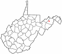 Location of Romney in West Virginia | |
| Coordinates: 39°20′42″N 78°45′25″W / 39.34500°N 78.75694°WCoordinates: 39°20′42″N 78°45′25″W / 39.34500°N 78.75694°W | |
| Country | United States |
| State | West Virginia |
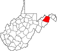
| County | Hampshire |
| Government | |
| • Mayor | Daniel O. Hileman |
| Area[1] | |
| • Total | 0.96 sq mi (2.49 km2) |
| • Land | 0.96 sq mi (2.49 km2) |
| • Water | 0 sq mi (0 km2) |
| Elevation | 820 ft (820 m) |
| Population (2010)[2] | |
| • Total | 1,848 |
| • Estimate (2013)[3] | 1,796 |
| • Density | 1,925.0/sq mi (743.2/km2) |
| Time zone | EST (UTC-5) |
| • Summer (DST) | EDT (UTC-4) |
| ZIP code | 26757 |
| Area code(s) | 304 |
| FIPS code | 54-70084 |
| GNIS feature ID | 1560582[4] |
| Website | City of Romney |
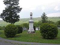
Romney is a city in and the county seat of Hampshire County, West Virginia, USA.[5] The population was 1,940 at the 2000 census, while the area covered by the city's ZIP code had a population of 5,873. The population was 1,848 at the 2010 census. Originally settled in 1725 by hunters and traders, Romney was known as Pearsall's Flats and was the site of the French and Indian War stockade Fort Pearsall. Romney is the oldest town in West Virginia, chartered December 23, 1762. (This status is contested by Shepherdstown, which was chartered in the same year). Named for the Cinque Ports town of Romney, Kent, England by Thomas Fairfax, 6th Lord Fairfax of Cameron, the town still bears placenames and symbols from its colonial past such as its Marsham Street, named for Robert Marsham, 2nd Baron Romney. It is also home to the West Virginia Schools for the Deaf and Blind and the nation's First Confederate Memorial in Indian Mound Cemetery.
Geography
Romney is located at 39°20′42″N 78°45′25″W / 39.34500°N 78.75694°W (39.344915, -78.756960).[6]
According to the United States Census Bureau, the city has a total area of 0.96 square miles (2.49 km2), all of it land.[1]
Climate
The climate in this area is characterized by hot, humid summers and generally cold winters. According to the Köppen Climate Classification system, Romney has a humid continental climate, abbreviated "Cfa" on climate maps.[7]
Demographics
| Historical population | |||
|---|---|---|---|
| Census | Pop. | %± | |
| 1850 | 456 | — | |
| 1860 | 569 | 24.8% | |
| 1870 | 482 | −15.3% | |
| 1880 | 371 | −23.0% | |
| 1890 | 451 | 21.6% | |
| 1900 | 580 | 28.6% | |
| 1910 | 1,112 | 91.7% | |
| 1920 | 1,028 | −7.6% | |
| 1930 | 1,441 | 40.2% | |
| 1940 | 2,013 | 39.7% | |
| 1950 | 2,059 | 2.3% | |
| 1960 | 2,203 | 7.0% | |
| 1970 | 2,364 | 7.3% | |
| 1980 | 2,094 | −11.4% | |
| 1990 | 1,966 | −6.1% | |
| 2000 | 1,940 | −1.3% | |
| 2010 | 1,848 | −4.7% | |
| Est. 2015 | 1,773 | [8] | −4.1% |
| U.S. Decennial Census[9] 2013 Estimate[3] | |||
2010 census
As of the census[2] of 2010, there were 1,848 people, 843 households, and 410 families residing in the city. The population density was 1,925.0 inhabitants per square mile (743.2/km2). There were 967 housing units at an average density of 1,007.3 per square mile (388.9/km2). The racial makeup of the city was 95.8% White, 2.7% African American, 0.2% Native American, 0.1% Asian, 0.1% from other races, and 1.1% from two or more races. Hispanic or Latino of any race were 1.4% of the population.

There were 843 households of which 23.7% had children under the age of 18 living with them, 31.2% were married couples living together, 13.2% had a female householder with no husband present, 4.3% had a male householder with no wife present, and 51.4% were non-families. 46.5% of all households were made up of individuals and 26.2% had someone living alone who was 65 years of age or older. The average household size was 2.01 and the average family size was 2.83.
The median age in the city was 41.9 years. 23.6% of residents were under the age of 18; 9.4% were between the ages of 18 and 24; 20.3% were from 25 to 44; 23% were from 45 to 64; and 23.6% were 65 years of age or older. The gender makeup of the city was 44.1% male and 55.9% female.
2000 census
As of the census of 2000, there were 1,940 people, 884 households, and 454 families residing in the city. The population density was 2,114.3 people per square mile (814.2/km²). There were 974 housing units at an average density of 1,061.5 per square mile (408.8/km²). The racial makeup of the city was 96.91% White, 1.91% African American, 0.05% Native American, 0.52% Asian, 0.21% from other races, and 0.41% from two or more races. Hispanic or Latino of any race were 0.67% of the population.
There were 884 households out of which 21.7% had children under the age of 18 living with them, 33.7% were married couples living together, 14.6% had a female householder with no husband present, and 48.6% were non-families. 44.8% of all households were made up of individuals and 26.8% had someone living alone who was 65 years of age or older. The average household size was 1.97 and the average family size was 2.72.
In the city the population was spread out with 25.2% under the age of 18, 7.4% from 18 to 24, 20.1% from 25 to 44, 21.3% from 45 to 64, and 26.1% who were 65 years of age or older. The median age was 42 years. For every 100 females there were 76.2 males. For every 100 females age 18 and over, there were 68.5 males.
The median income for a household in the city was $22,261, and the median income for a family was $34,271. Males had a median income of $28,667 versus $20,000 for females. The per capita income for the city was $15,765. About 17.2% of families and 24.6% of the population were below the poverty line, including 29.5% of those under age 18 and 18.2% of those age 65 or over.
History
American Civil War
Historic sites

- Arnold House (1770) The families Millar, Parker, and Arnold are associated with this house built in 1770. It was the home of Isaac Millar, a prominent officer during the American Revolutionary War, businessman and civic leader.
- Blue House (1900) This has been home to descendants of Lieutenant John Blue, famed Confederate spy, whose memoirs were published in Hanging Rock Rebel.
- Boxwood (1800) Reportedly sold for about $10 for unpaid taxes, the house was used as an American Civil War hospital. It is said that each of the 56 changes between the Northern and Southern armies during the Civil War in Romney took place under the great elm in the front yard.
- The Buffalo House at Fern Cliff (early 19th century) Isaac Pancake built the original log portion in the early 19th century. Recently restored with additions made, it is the home of John and Barbara Pancake.

- The Burg (c. 1769) Built around 1769, this property has been in the original family (Williams) for seven generations. It was used as headquarters by both armies during the Civil War.
- Cookman Building (1906) Built originally as the Bank of Romney building and served as the offices for the Hampshire Review newspaper until 2009.
- County Poor Farm (late 18th century) Originally a glebe-house for the local Episcopal church and then Hampshire County's "poor farm."
- Davis History House (1798) The Davis House was home to the Davis family which sent two sons to fight for the Confederacy and one for the Union. Now a museum, it features Civil War artifacts and period furnishings.
- Farmer's Exchange (late 19th century) At one time Shorty Mauk's store, the Farmer's Exchange has served as a store for the Romney community in some capacity for over one hundred years. It was abandoned after a fire in recent years but is still standing. Located at the intersection of Bolton St. and Birch Ln.
- Confederate Memorial (1867)
- First United Methodist Church (1904)
- Green Meadows (c. 1900) This farm served as the first sweet corn truck farm in Hampshire County.
- Hampshire County Courthouse (1922)

- Hickory Grove (1838) Adam Stump and wife, Mary Gregg Parsons, built the brick house in 1838. Their son, Captain George Stump, was killed by Yankee soldiers a short distance from his house just before the end of the war. The seventh generation of the family continue to live there. Hickory Grove is listed on the National Register of Historic Places.
- Indian Mound Cemetery
- Kerns House (c. 1780) Now the home of the American Legion, it was reportedly built by Hessian former prisoners of war soon after the American Revolutionary War ended. The front is Flemish bond construction, the sides of American bond. Much of the window glass is original.

- Kuykendall-Hicks House (mid-18th century) The north portion of the present structure was Fort Kuykendall built during the French and Indian War. Additions were made in 1814 by Isaac Pancake and a two-story addition was completed in 1987.
- Liberty Hall (1858) Traditionally referred to as Thomas "Stonewall" Jackson's headquarters, the house and grounds were used by both Union and Confederate troops at various times during the Civil War. It was built in 1858 by John Baker White, clerk of the circuit and superior court in Hampshire County, who fled to Richmond to escape arrest and served in the Confederate States Department of the Treasury.
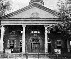
- Literary Hall (1870) As a meeting place of the Romney Literary Society, it housed the largest library west of the Blue Ridge Mountains. On the National Register of Historic Places, it features antique firearms, music boxes, and period furnishings.
- Mount Pisgah Benevolence Cemetery
- Pancake-Kuykendall House (1872) Situated on lot 12 of the Fairfax South Branch River Survey, it was built in 1872 by Joseph A. and Susan Parsons Pancake. Third generation Pancake family continue to live there.
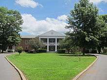
- Romney Classical Institute (1846) Extensively remodeled after 1870 when it became the administration building for the West Virginia Schools for the Deaf and Blind. Wings were added to the original Institute and another building was added in 1900 (the taller building in the picture shown to the right).
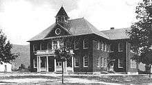
- Old Romney High School (1930) Originally built as a high school to replace the Old Romney Public School, and then converted into a junior high in the 1960s after the creation of Hampshire High School, and then into a middle school until the new Romney Middle School was opened in December 2004. [History of Romney Middle School] Now is used as a building for Romney Elementary School.

- Romney Presbyterian Church (1860) It was used as a hospital and stable during the Civil War. Originally it had a bell tower and steeple, but those were removed because of the weakened condition of the building. Iron rails outside and rods inside were added to reinforce the walls.
- Saint Stephen's Episcopal Church (1885) Built in 1885 for $1800, this small brick church features Gothic windows and tiny porticos. The Tiffany-style altar window is in memory of the minister who served from 1886 to 1915. The marble baptismal font predates the church building.
- School House (1825) Built as a church around 1825, it suffered a fire in 1853. From 1866 to 1906 it served as public school, with primary grades continuing to be housed there for some time after. It became a private home in 1914.

- Sycamore Dale (1836) Referred to in the General Lew Wallace raid of June 12, 1861, Sycamore Dale was built by David Gibson in 1836. The house is listed on the National Register of Historic Places. Wallace wrote a portion of Ben-Hur: A Tale of the Christ here.
- Taggart Hall (c. 1790s) Frances Taggart, a Quaker, constructed this clapboard "half" house on a lot from the Lord Fairfax survey. It now serves as headquarters for the Fort Mill Ridge Foundation Museum & Exhibit Center.
- Valley View (1855)
- Van Meter Fort (1754) Used as a French and Indian War fort, this structure is adjacent to the Kuykendall house. It shows the gun slits and relatively fireproof construction. Its surviving blockhouse is listed in the National Register of Historic Places.
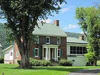
- Wappocomo (1774) The main part of the house was built in 1774 from bricks used as ballast on English ships, off-loaded at Newport News, and hauled across the mountains by oxen. It has been home to six generations of the original family.
- Washington Place (late 19th century) Restored cabin built by the Washingtons, a family of freed slaves.
- Wilson-Wodrow-Mytinger House (c. 1760) Romney's oldest house features three buildings. The main house reflects architecture of the Jamestown area. The clerk's office, West Virginia's oldest public office building, 1788, was constructed in a Williamsburg. These structures are listed in the National Register of Historic Places.
Parks and recreation
- Hampshire High School Sports Complex, US Route 50 East
- Baseball Field, Cross Country Trails, Running Track, Soccer Field, Softball Field
- Hampshire Park & 4-H Camp, South Branch River Road (CR 8)
- Picnic Pavilions, Baseball Field, Basketball Court, Volleyball Court, Tennis Courts
- Old Romney High School, 111 School Street
- Baseball Field, Basketball Courts, Football Field, Running Track
- Romney Recreation Center, 260 School Street
- Swimming Facilities
- West Virginia Schools for the Deaf and Blind Grounds, East Main Street
- Baseball Field, Basketball Courts, Picnic Pavilions, Running Track, Soccer Field, Swimming Facilities

Notable people
- Stephen Ailes, 8th United States Secretary of the Army
- William Armstrong, United States Representative
- John Rinehart Blue, West Virginia House Delegate
- William C. Clayton, West Virginia State Senator
- Edna Brady Cornwell, First Lady of West Virginia
- John J. Cornwell, 15th Governor of West Virginia
- William B. Cornwell, lawyer, businessperson, newspaper editor and publisher, and railroad and timber executive
- John Collins Covell, West Virginia Schools for the Deaf and Blind principal
- Samuel Lightfoot Flournoy, West Virginia State Senator and mayor of Romney
- Samuel Lightfoot Flournoy, prominent Charleston lawyer
- Henry Bell Gilkeson, West Virginia State Senator, West Virginia House of Delegates member, Principal of the West Virginia Schools for the Deaf and Blind, and Superintendent of Hampshire County Schools
- Howard Hille Johnson, founder of and educator at the West Virginia Schools for the Deaf and Blind
- James Sloan Kuykendall, West Virginia House Delegate and mayor of Romney
- Charles S. Lawrence, Institute of Food Technologists Executive Vice President
- Thomas Bryan Martin, burgess, jurist, and the county's first judge
- Angus William McDonald, Confederate States Army colonel
- Marshall McDonald, United States Fish Commissioner
- Jerry Mezzatesta, West Virginia House Delegate
- Alexander W. Monroe, Speaker of the West Virginia House of Delegates
- Ann Pancake, author
- Catherine Pancake, filmmaker
- Sam Pancake, actor
- Isaac Parsons, Virginia militia officer and Virginia House Delegate
- Isaac Parsons, Confederate military officer and Virginia House Delegate
- Lee Hawse Patteson, First Lady of West Virginia
- Randall Terry, pro-life activist
- Christian Streit White, Clerk of Court for Hampshire County
- John Baker White, Longest serving Clerk of Court for Hampshire County
- John Baker White, Military officer and West Virginia Board of Control member
- Robert White, Attorney General of West Virginia
- Robert White, Prosecuting Attorney for Hampshire County and West Virginia State Senator
- Charles M. Williams, Harvard Business School professor
- Andrew Wodrow, trustee of Romney and Clerk of Court for Hampshire County
- Joshua Soule Zimmerman, West Virginia House Delegate
References
- 1 2 "US Gazetteer files 2010". United States Census Bureau. Retrieved 2013-01-24.
- 1 2 "American FactFinder". United States Census Bureau. Retrieved 2013-01-24.
- 1 2 "Population Estimates". United States Census Bureau. Retrieved 2014-08-27.
- ↑ "US Board on Geographic Names". United States Geological Survey. 2007-10-25. Retrieved 2008-01-31.
- ↑ "Find a County". National Association of Counties. Retrieved 2011-06-07.
- ↑ "US Gazetteer files: 2010, 2000, and 1990". United States Census Bureau. 2011-02-12. Retrieved 2011-04-23.
- ↑ Climate Summary for Romney, West Virginia
- ↑ "Annual Estimates of the Resident Population for Incorporated Places: April 1, 2010 to July 1, 2015". Retrieved July 2, 2016.
- ↑ United States Census Bureau. "Census of Population and Housing". Retrieved August 27, 2013.
- Ailes, John C. Romney, West Virginia, 1762-1962. Romney, West Virginia, Hampshire Review, 1962.
- Ambler, Charles Henry. "Romney In The Civil War." West Virginia History, Charleston, West Virginia, 1943-44. Arc 1. 4: 5.
- Ansel, William H., Jr. Frontier Forts Along The Potomac And Its Tributaries. Parsons, West Virginia, McClain Publishing Company, reprint 1995.
- Brannon, Selden W. Historic Hampshire. Parsons, West Virginia, McClain Printing Company, 1976.
- Hampshire County 250th Anniversary Committee: Hampshire County, West Virginia, 1754-2004. 2004.
- Maxwell, Hu. History of Hampshire County, West Virginia: From its earliest settlement to the present. Morgantown, West Virginia, A.B. Boughner, 1897.
- Romney Town Council. Historic Romney, 1762-1937. Romney, 1937.
- Sauers, Richard A. The Devastating Hand of War: Romney, West Virginia During the Civil War. Leesburg, Virginia, Gauley Mount Press, 2000.
City of Romney links
- www.RomneyWV.com
- Hampshire County Schools
- Romney Elementary School
- Romney Middle School
- Hampshire County Chamber of Commerce
- Hampshire Review Newspaper
- Hampshire County History Homepage
- Hampshire County Public Library
- Hampshire High School
- West Virginia School for the Deaf & Blind Homepage
Romney maps & images
![]() Media related to Romney, West Virginia at Wikimedia Commons
Media related to Romney, West Virginia at Wikimedia Commons
| Wikimedia Commons has media related to Romney, West Virginia. |