Carpendale, West Virginia
| Carpendale, West Virginia | |
|---|---|
| Town | |
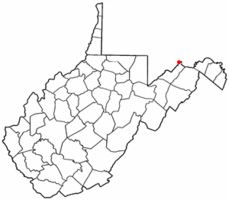 Location of Carpendale, West Virginia | |
| Coordinates: 39°37′55″N 78°47′12″W / 39.63194°N 78.78667°WCoordinates: 39°37′55″N 78°47′12″W / 39.63194°N 78.78667°W | |
| Country | United States |
| State | West Virginia |
| County | Mineral |
| Area[1] | |
| • Total | 1.31 sq mi (3.39 km2) |
| • Land | 1.31 sq mi (3.39 km2) |
| • Water | 0 sq mi (0 km2) |
| Population (2010)[2] | |
| • Total | 977 |
| • Estimate (2012[3]) | 965 |
| • Density | 745.8/sq mi (288.0/km2) |
| Time zone | Eastern (EST) (UTC-5) |
| • Summer (DST) | EDT (UTC-4) |
| Area code(s) | 304 |
| FIPS code | 54-13525[4] |
Carpendale is a town in Mineral County, West Virginia, United States, and part of the 'Cumberland, MD-WV Metropolitan Statistical Area'. The population was 977 at the 2010 census. Carpendale was incorporated on January 2, 1990 by the Circuit Court. The town is a combination of three subdivisions of which its name reflects: Carpenters Addition, Millerdale I, and Millerdale II. There are no stores in Carpendale and there is only one road in and out of the town.
Geography
Carpendale is located at 39°37′55″N 78°47′12″W / 39.63194°N 78.78667°W (39.631847, -78.786674).[5]
According to the United States Census Bureau, the town has a total area of 1.31 square miles (3.39 km2), all of it land.[1]
Demographics
| Historical population | |||
|---|---|---|---|
| Census | Pop. | %± | |
| 2000 | 954 | — | |
| 2010 | 977 | 2.4% | |
| Est. 2015 | 937 | [6] | −4.1% |
2010 census
As of the census[2] of 2010, there were 977 people, 402 households, and 286 families residing in the town. The population density was 745.8 inhabitants per square mile (288.0/km2). There were 421 housing units at an average density of 321.4 per square mile (124.1/km2). The racial makeup of the town was 98.9% White, 0.5% African American, 0.1% Native American, 0.3% Asian, and 0.2% from two or more races.
There were 402 households of which 24.6% had children under the age of 18 living with them, 59.0% were married couples living together, 8.2% had a female householder with no husband present, 4.0% had a male householder with no wife present, and 28.9% were non-families. 23.6% of all households were made up of individuals and 12.2% had someone living alone who was 65 years of age or older. The average household size was 2.43 and the average family size was 2.86.
The median age in the town was 43.4 years. 19.2% of residents were under the age of 18; 6.9% were between the ages of 18 and 24; 26.5% were from 25 to 44; 24.7% were from 45 to 64; and 22.5% were 65 years of age or older. The gender makeup of the town was 49.0% male and 51.0% female.
2000 census
As of the census[4] of 2000, there were 954 people, 383 households, and 284 families residing in the town. The population density was 722.4 inhabitants per square mile (279.0/km²). There were 404 housing units at an average density of 305.9 per square mile (118.2/km²). The racial makeup of the town was 99.27% White, 0.10% African American, and 0.63% from two or more races. Hispanic or Latino of any race were 0.21% of the population.
There were 383 households out of which 29.0% had children under the age of 18 living with them, 62.1% were married couples living together, 8.6% had a female householder with no husband present, and 25.6% were non-families. 21.9% of all households were made up of individuals and 10.4% had someone living alone who was 65 years of age or older. The average household size was 2.49 and the average family size was 2.89.
In the town the population was spread out with 22.1% under the age of 18, 7.9% from 18 to 24, 24.9% from 25 to 44, 32.0% from 45 to 64, and 13.1% who were 65 years of age or older. The median age was 40 years. For every 100 females there were 95.5 males. For every 100 females age 18 and over, there were 93.5 males.
The median income for a household in the town was $35,404, and the median income for a family was $37,235. Males had a median income of $31,250 versus $20,795 for females. The per capita income for the town was $15,588. About 3.6% of families and 7.0% of the population were below the poverty line, including 5.6% of those under age 18 and 5.0% of those age 65 or over.
References
- 1 2 "US Gazetteer files 2010". United States Census Bureau. Archived from the original on 2012-07-14. Retrieved 2013-01-24.
- 1 2 "American FactFinder". United States Census Bureau. Retrieved 2013-01-24.
- ↑ "Population Estimates". United States Census Bureau. Archived from the original on 2013-06-17. Retrieved 2013-06-26.
- 1 2 "American FactFinder". United States Census Bureau. Archived from the original on 2013-09-11. Retrieved 2008-01-31.
- ↑ "US Gazetteer files: 2010, 2000, and 1990". United States Census Bureau. 2011-02-12. Retrieved 2011-04-23.
- ↑ "Annual Estimates of the Resident Population for Incorporated Places: April 1, 2010 to July 1, 2015". Retrieved July 2, 2016.
- ↑ "Census of Population and Housing". Census.gov. Archived from the original on May 11, 2015. Retrieved June 4, 2015.
Municipalities and communities of Mineral County, West Virginia, United States | ||
|---|---|---|
| City | 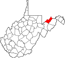 | |
| Towns | ||
| CDPs | ||
| Other localities |
| |
| Ghost towns | ||
| Footnotes | ‡This populated place also has portions in an adjacent county or counties | |