George Washington and Jefferson National Forests
| George Washington and Jefferson National Forests | |
| U.S. National Forests | |
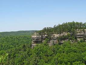
 White Rocks on Little Sluice Mountain in George Washington National Forest. | |
| Country | United States |
|---|---|
| States | Kentucky, Virginia, West Virginia |
| Ranger Districts | Clinch, Eastern Divide, Glenwood-Pedlar, James River, Lee, Mount Rogers, North River, Warm Springs |
| Coordinates | 38°30′0″N 79°0′0″W / 38.50000°N 79.00000°WCoordinates: 38°30′0″N 79°0′0″W / 38.50000°N 79.00000°W |
| Highest point | Mount Rogers |
| - location | Grayson and Smyth Counties, VA |
| - elevation | 5,729 ft (1,746.2 m) |
| - coordinates | 36°39′35″N 81°3′41″W / 36.65972°N 81.06139°W |
| Lowest point | South Fork Shenandoah River |
| - location | southwest of Front Royal, VA |
| - elevation | 513 ft (156.4 m) |
| - coordinates | 38°52′31″N 78°18′34″W / 38.87528°N 78.30944°W |
| Area | 1,790,933 acres (724,764.9 ha) |
| Established | 1995 [1] |
| - George Washington NF | 1918-05-16 [2] |
| - Jefferson NF | 1936-04-21 [2] |
| Owner | US Forest Service |
| IUCN category | VI - Managed Resource Protected Area |
| Headquarters | Roanoke, Virginia |
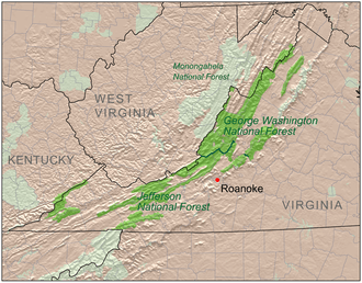 Location of George Washington and Jefferson National Forests | |
| Wikimedia Commons: George Washington and Jefferson National Forests | |
| Website: George Washington and Jefferson National Forests | |
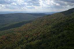
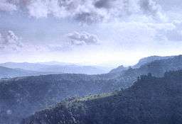
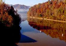
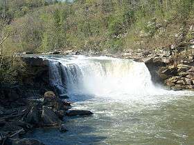
The George Washington and Jefferson National Forests are U.S. National Forests that combine to form one of the largest areas of public land in the Eastern United States. They cover 1.8 million acres (7,300 km2) of land in the Appalachian Mountains of Virginia, West Virginia, and Kentucky. Approximately 1 million acres (4,000 km2) of the forest are remote and undeveloped and 139,461 acres (564 km2)[3] have been designated as wilderness areas, which eliminates future development.
History
George Washington National Forest was established on May 16, 1918 as the Shenandoah National Forest. The forest was renamed after the first President on June 28, 1932. Natural Bridge National Forest was added on July 22, 1933.[2]
Jefferson National Forest was formed on April 21, 1936 by combining portions of the Unaka and George Washington National Forests with other land.[2] In 1995, the George Washington and Jefferson National Forests were administratively combined.[1] The border between the two forests roughly follows the James River. The combined forest is administered from its headquarters in Roanoke, Virginia.[1]
Notable features
- The northern portion of the Blue Ridge Parkway, which is separately administered by the National Park Service, runs through the Forest.
- Over 2,000 miles (3,000 km) of hiking trails go through the forest.
- Virginia's highest point, Mount Rogers, is located in the Mount Rogers National Recreation Area that is part of the forest. Other notable mountains include Elliott Knob, which has one of the last remaining fire lookout towers in the eastern U.S., and Whitetop Mountain.
- Approximately 230,000 acres (930 km2) of old-growth forests.
- The deepest gorge east of the Mississippi River, Breaks Interstate Park, is located in the forest.
- Roaring Run Furnace is the only site on the National Register of Historic Places owned by the Jefferson National Forest.[4]
Flora and fauna

The Forests' vast and mountainous terrain harbors a great variety of plant life—over 50 species of trees and over 2,000 species of shrubs and herbaceous plants.[5]
The Forests contain some 230,000 acres (930 km2) of old growth forests, representing all of the major forest communities found within them.[6][7] Locations of old growth include Peters Mountain, Mount Pleasant National Scenic Area, Rich Hole Wilderness, Flannery Ridge, Pick Breeches Ridge, and Laurel Fork Gorge, Pickem Mountain, and Mount Rogers National Recreation Area.[8] The Ramsey's Draft and Kimberling Creek Wildernesses in particular are mostly old-growth.[8][9][10]
The black bear is relatively common, enough so that there is a short hunting season to prevent overpopulation. White-tailed deer, bobcat, bald eagles, weasel, otter, and marten are also known to inhabit the Forests.
Activities
The forests are popular hiking, mountain biking, and hunting destinations. The Appalachian Trail extends for 330 miles (530 km) from the southern end of Shenandoah National Park through the forest and along the Blue Ridge Parkway. The forest is within a two-hour drive for over ten million people and thus receives large numbers of visitors, especially in the region closest to Shenandoah National Park.
The George Washington National Forest is a popular destination for trail runners. It is the location for several Ultramarathons, including the Massanutten Mountain Trails 100 miler, the Old Dominion 100 miler, and the Old Dominion Memorial 100 miler.[11]
George Washington Forest is also the venue for Nature Camp, a natural science education-oriented summer camp for youth.[12] The camp is located on national forest land near the town of Vesuvius, Virginia. It has operated at this location since the summer of 1953.[13]
Counties
Note that Jefferson National Forest is located in 22 separate counties, more than any other National Forest except Mark Twain National Forest in Missouri, which lies in 29 counties. Note also that Botetourt, Monroe, and Rockbridge counties, at the dividing line between the two forests, include parts of both forests. Thirdly, note that the state of Kentucky actually has very little area, with its two counties bringing up the tail end of Jefferson National Forest.
Ranger District Offices
Ranger offices are the Forest Service's public service offices. Maps and other information about the forests can be obtained at these locations. These offices are open Monday through Friday from 8:00 a.m. to 4:30 p.m. The Supervisor's Office in Roanoke is not located in the forest and is primarily an administrative location.[15]
District offices are listed from north to south. Counties are in Virginia unless otherwise indicated.
| District | Office Location | Counties served |
|---|---|---|
| Lee Ranger District | Edinburg, Virginia | Frederick, Hampshire (WV), Hardy (WV), Page, Rockingham, Shenandoah, Warren |
| North River Ranger District | Harrisonburg, Virginia | Augusta, Highland, Pendleton (WV), Rockingham |
| Warm Springs Ranger District | Hot Springs, Virginia | Bath, Highland |
| James River Ranger District | Covington, Virginia | Alleghany |
| Glenwood-Pedlar Ranger District | Natural Bridge Station, Virginia | Amherst, Augusta, Bedford, Botetourt, Nelson, and Rockbridge |
| Eastern Divide Ranger District | Blacksburg, Virginia | Bland, Botetourt, Craig, Giles, Monroe (WV), Montgomery, Pulaski, Roanoke, Smyth, Tazewell, Wythe |
| Clinch Ranger District | Norton, Virginia | Dickenson, Lee, Letcher (KY), Pike (KY), Scott, Wise |
| Mount Rogers National Recreation Area | Marion, Virginia | Carroll, Grayson, Smyth, Washington, Wythe |
Wilderness areas
There are 139,461 acres (564 km2)[3] of federally designated wilderness areas in the two forests under the United States National Wilderness Preservation System. All are in the state of Virginia, except as indicated. The largest of these is the Mountain Lake Wilderness, at 16,511 acres (67 km2). There are 17 wildernesses in Jefferson National Forest, second only to Tongass National Forest, which has 19.
George Washington National Forest
- Barbours Creek Wilderness (part)
- Priest Wilderness
- Ramseys Draft Wilderness
- Rich Hole Wilderness
- Rough Mountain Wilderness
- Saint Mary's Wilderness
- Shawvers Run Wilderness (part)
- Three Ridges Wilderness
Jefferson National Forest
- Barbours Creek Wilderness (most)
- Beartown Wilderness
- Brush Mountain East Wilderness
- Brush Mountain Wilderness
- Garden Mountain Wilderness
- Hunting Camp Creek Wilderness
- James River Face Wilderness
- Kimberling Creek Wilderness
- Lewis Fork Wilderness
- Little Dry Run Wilderness
- Little Wilson Creek Wilderness
- Mountain Lake Wilderness (Virginia / West Virginia)
- Peters Mountain Wilderness
- Raccoon Branch Wilderness
- Shawvers Run Wilderness (most)
- Stone Mountain Wilderness
- Thunder Ridge Wilderness
History
The first camp of the Civilian Conservation Corps NF-1, Camp Roosevelt,[16] was established in the George Washington National Forest near Luray, Virginia. It is now the site of the Camp Roosevelt Recreation Area.[17]
See also
- Great North Mountain
- Massanutten Mountain
- Shenandoah Mountain
- Monongahela National Forest—adjoining forest in West Virginia
References
- 1 2 3 "Forest Facts". George Washington and Jefferson National Forests. Archived from the original on 2009-01-18. Retrieved 2009-01-18.
- 1 2 3 4 Davis, Richard C. (2005-09-29). "The National Forests of the United States". The Forest History Society. Archived from the original (PDF) on 2008-01-17. Retrieved 2009-01-18.
- 1 2 Wilderness.net search page
- ↑ Virginia Historic Landmarks Commission Staff (2014). "Roaring Run Furnace". Virginia Tourism Corporation.
- ↑ "George Washington & Jefferson National Forest Trees & Shrubs". George Washington and Jefferson National Forests. Archived from the original on 2009-01-17. Retrieved 2009-01-17.
- ↑ George Washington National Forest 1993 Revised Forest Plan. United States Forest Service. 1993.
- ↑ Jefferson National Forest 2004 Revised Forest Plan. United States Forest Service. 2004.
- 1 2 Mary Byrd Davis (23 January 2008). "Old Growth in the East: A Survey. Virginia" (PDF).
- ↑ Jefferson National Forest South Half. Old Growth Inventory Map. (PDF). United States Forest Service, Southern Region. 1997.
- ↑ Jefferson National Forest South Half. Wilderness, Roadless, and Wild & Scenic Rivers Map. (PDF). United States Forest Service, Southern Region. 1997.
- ↑ Run100s ("Run Hundreds") – A Not-For-Profit UltraRunning Corporation
- ↑ Nature Camp
- ↑ History of Nature Camp
- ↑ "Table 6 - NFS Acreage by State, Congressional District and County" (PDF). Land Areas Report. US Forest Service. 18 October 2014. Retrieved 8 February 2016.
- ↑ "Districts". United States Forest Service. Retrieved 8 February 2016.
- ↑ Archived January 27, 2012, at the Wayback Machine.
- ↑ George Washington 26 Jefferson National Forest – Camp Roosevelt Recreation Area. Fs.usda.gov. Retrieved on 2013-08-09.
- Hall, William L. (July 1914). "To Remake The Appalachians: A New Order In The Mountains That is Founded On Forestry – What The Government's Appalachian Forests Mean To The People In The Mountains And To The Millions Who Want Recreation". The World's Work: A History of Our Time. Doubleday, Page & Co. XLIV (2): 321–338. Retrieved 2009-08-04.
- Jefferson National Forest: An Appalachian Environmental History. Knoxville: University of Tennessee Pr., 2011.
- Prehistoric Southwest Virginia: Aboriginal Occupation, Land Use, and Environmental Worldview, Smithfield Review 5 (April 2000): 125–151.
- Turnpike Tourism in Western Virginia, Virginia Cavalcade 48:1 (Winter 1998): 14–23.
- The Potts Valley Branch Railroad and Tri-State Incline Lumber Operation in West Virginia and Virginia, 1892–1932, West Virginia History 54 (1995): 42–58.
- The Mount Rogers National Recreation Area and the Rise of Public Involvement in Forest Service Planning, Environmental History Review 28 (Summer 1994): 41–65.
- An Appalachian Forest: Creation of the Jefferson National Forest and its effects on the local community, Forest and Conservation History 37:4 (October 1993): 169–178.
- The Great Anti-Fire Campaign, American Forests, 99:5&6 (May/June 1993): 33–35, 58.
- Green Cove Station: An Appalachian train depot and its community, Virginia Cavalcade, 42:2 (Autumn 1992): 52–61.
- Fisheries and Wildlife Management: part of the history of the Jefferson National Forest, Virginia Forests, 48:2 (Summer 1992): 6–8.
External links
| Wikimedia Commons has media related to George Washington and Jefferson National Forests. |
- George Washington and Jefferson National Forests
- U.S. Forest Service, George Washington National Forest, Dry River District Collection at James Madison University's Special Collections.
| Parks |
|      | ||||||||||
|---|---|---|---|---|---|---|---|---|---|---|---|---|
| Museums |
| |||||||||||
| Forests | ||||||||||||
| Reservoirs | ||||||||||||
| Natural features | ||||||||||||
| Miscellaneous |
| |||||||||||
| |
| Military career Revolutionary War |
|
| Other U.S. founding events | |
| Presidency |
|
| Views and public image | |
| Life and homes |
|
| Memorials and depictions |
|
| Related |
|
| Ancestry and family |
|
| |
| |
| Founding documents of the United States | |
| French Revolution | |
| Presidency |
|
| Other noted accomplishments |
|
| Jeffersonian architecture | |
| Other writings | |
| Related |
|
| Elections | |
| Legacy |
|
| Popular culture |
|
| Family |
|
| |