Sethiathoppu
| Sethiathoppu Sethiyathope | |
|---|---|
| city | |
 Sethiathoppu Location in Tamil Nadu, India | |
| Coordinates: 11°16′N 79°19′E / 11.26°N 79.32°ECoordinates: 11°16′N 79°19′E / 11.26°N 79.32°E | |
| Country |
|
| State | Tamil Nadu |
| District | Cuddalore |
| Government | |
| • President | K.P.D. Elanchezhiyan |
| Population (2001) | |
| • Total | 7,962 |
| Languages | |
| • Official | Tamil |
| Time zone | IST (UTC+5:30) |
| PIN | 608702 |
| Telephone code | 91-04144 |
| Vehicle registration | TN-91( TN-31 till Jun17,2015) |
| Website |
www |
Sethiathopuu (pronounced [ˈsetiaːtopu]) is a panchayat town in Cuddalore district in the Indian state of Tamil Nadu. It is situated on the crossroads of Chennai - Tanjore (NH-45C) Highway. Sethiyathope was established as a civilian town by the Cholas in the 11th century C.E. According to Tamil Scholars, Sethiyathope was formed as a settlement when the famous Chola King Rajendra moved his capital from Tanjavoor to Gangaikonda Cholapuram which lies 20 km South. Sethiyaar, a landlord used to own this piece of woodlands (Thoppu) on the banks of river Vellar and thus derives the name Sethiyarthoppu (Sethiathope).There are close to 60 villages around this town largely agrarian communities.
Demographics
As of 2001 India census,[1] Sethiathoppu had a population of 7962. Males constitute 52% of the population and females 48%. Sethiathoppu has an average literacy rate of 72%, higher than the national average of 59.5%: male literacy is 80%, and female literacy is 64%. In Sethiathoppu, 10% of the population is under 6 years of age.
How to reach Sethiyathope
By Road : NH 45C - Between kumbakonam to Chennai. Distance between Chennai to Sethiyathope is 222 km and Kumbakonam to Sethiyathope Distance is 60 km (Source - Google Map).
By Train : Chennai to Chidambaram Junction and Chennai to Virudhachalam Junctions are near to Sethiyathope.
Other Cities Near to Sethiyathope :
- Chidambaram - 20 km Distance (1 Hour Travel Time)
- Virudhachalam - 25 km Distance ( 1 Hour and 15 Minutes Travel Time)
- Vadalur - 20 km ( 30 minutes Travel time)
- Srimushnam - 20 km ( 40 minutes Travel Time )
There are Primary Health Centre (GH), Police Station, Couple of Higher Secondary and Nursing schools situated here.
Totally 15 wards in Sethiyathope Panchayat.
Tourist attractions
Veeranam Lake
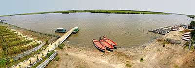
Veeranam Lake, located 2 kilometres South of Sethiathope is the second largest lake in the state of Tamil Nadu. The lake located 235 km from Chennai, India, is one of the important water reservoirs that supplies drinking water to Chennai. Veeranam Lake was created during Chola period in the tenth century, built from 1011 to 1037 AD[3] and is an 16 km (9.9 mi) long dam in northern Tamil Nadu.
Birth Place of Ramalinga Swamigal
Arutprakasa Vallalar Chidambaram Ramalingam (Tamil: அருட்பிரகாச வள்ளலார் சிதம்பரம் இராமலிங்க அடிகள்), (5 October 1823 – 30 January 1874), whose pre-monastic name was Ramalingam, is commonly known in India and across the world[1] as Vallalar (Tamil: வள்ளலார்). He was one of the most famous Tamil Saints and also one of the greatest Tamil poets of the 19th century[2] and belongs to a line of Tamil saints known as "gnana siddhars" (gnana means higher wisdom). The Suddha Sanmarga Sangam[3] was spread and passed on by him not only in theory but mainly in practice by his own way of living which was itself inspiration for his followers. Through the notion of Suddha Sanmarga Sangam, the saint endeavored to eliminate the menace of caste.[4] According to Suddha Sanmarga, the prime aspects of human life should be love connected with charity and divine practice leading to achievement of pure knowledge.
Ramalinga Adigal was the youngest child of Ramiah Pillai and his sixth wife Chinnamaiar, who lived in Marudur in South Arcot district, a village 7 km north of Sethiyathoppu in the National Highway 45C.
Gangaikonda Cholapuram
Gangaikonda Cholapuram (Tamil: கங்கைகொண்ட சோழபுரம்) was erected as the capital of the Cholas by Rajendra Chola I, the son and successor of Rajaraja Chola, the great Chola who conquered a large area in South India at the beginning of the 11th century C.E. It occupies an important place in the history of India. As the capital of the Cholas from about 1025 C.E. for about 250 years, the city controlled the affairs of entire south India, from the Tungabhadra in the north to Ceylon in the south. The great temple of Siva at this place is next only to the Brihadisvara temple at Thanjavur in its monumental nature and surpasses it in sculptural quality.
Gangaikonda Cholapuram is located 15 km south of Sethiathoppu in the National Highway 45C. Gangaikonda Cholapuram can be reached by taxi and bus from Sethiathoppu.
Birth Place of Raghavendra Swami
Sri Guru Raghavendra Swamy (1595–1671) is an influential 16th-century Hindu saint who advocated Vaishnavism (worship of Vishnu as the supreme God) and Sri Madhvacharya's Dvaita philosophy. He ascended Brindavana at Mantralayam in present-day Andhra Pradesh in 1671. Sri Raghavendra Swami was born as Sri Venkanna Bhatta, the second son of Sri Thimanna Bhatta and Smt. Gopikamba on Thursday, Sukla Saptami of Phalguna month in 1595, when the moon was in Mrigashirisha Nakshatra, at Bhuvanagiri, near present-day Chidambaram in Tamil Nadu.
Bhuvanagiri is about 11 Kilometers east of Sethiathoppu on the National Highway 227. Bhuvanagiri can also be reached from Sethiathoppu by State Highway 70.
Nataraja Temple, Chidambaram

The ancient Chidambaram Temple (Tamil: சிதம்பரம் கோயில் ) is dedicated to Lord Shiva in His form of the Cosmic Dancer (Nataraja நடராசர்) . It is one of the five Dancing Halls (Sabha) of Nataraja and the most famous one. Chidambaram hosts the most ancient set of 108 Karana stone carvings, the key dance movements of Nataraja. The temple complex is spread over 40 acres (160,000 m2) in the heart of the city. Many thousands of devotees come to this auspicious temple to pay homage to the Dancing Siva.
Chidambaram is located in the Kollidam River valley about 11 km from the Bay-of-Bengal coast, 20 km east of Sethiathoppu in NH 227 and 240 km south of Chennai by rail
Pichavaram Mangrove Forest
Pichavaram the second largest Mangrove forest in the world, near the temple town of Chidambaram, is one of the unique Eco-tourism spots in South India. The backwaters, inter connected by the Vellar and Coleroon river systems, offer abundant scope for water sports, rowing, Kayak and canoeing. Pichavaram mangroves are considered among the healthiest mangrove occurrence in the world. Pichavaram consists of a number of islands interspersing a vast expanse of water covered with green trees. The area is about 2,800 acres (11 km2) and is separated from the sea by a sand bar which is a patch of extraordinary loveliness. Pitchavaram is located on the Bay-of-Bengal coast about 20 km east of Sethiathoppu.
Nearby villages
- Muganthariyan Kuppam
- Madhuvanaimedu,this village people's are based to vanniya Kulla Kshatriyar family. most powerful vinnayagar temple, Sri throwpati amman kovil,veeranaar kovil,iyyannar temple, then biggest lake water store for 500 acres and all are depending upon agriculture it's natural village,,....
- Allur: This village is nearby sethiyathope. Here Maha Sakthi Mariyamman kovil is famous and it's god is powerful one. Well educated and decent village.
- 'senninatham Arulmigu padariamman Temple Nearest Government hospital.
- Anaivari, Cuddalore: This village is 2 kilo meter from sethiyathope.it is agriculture dependent village.main Cultivating is sugercane and paddy.Hereplaced one of the famous KaliAmman kovil in anaivari mattu street.
- North Senninatham, which is very near to Sethiyathope. Arulmigu Sree Madhurakaaliyamman temple is there.
- Periyanarkunam: This village is 5 km from sethiyathope, here Kalli Amman kovil, Chithra Powrnami festival famous, every month powrnami day in around from Tamil Nadu, people are come for Kuri, well educated village
- Paripoorananatham
- Chinnanarkunam
- Boothangudi
- Maduranthaga Nallur
- cinnaKuppam
- veeramudaiyanatham
- Vattathur
- Solatharam
- Madhuvanaimedu
- Erumbur
- periyaKuppam
- cinna Kuppam
- Pinnalur
- Miralur
- Kilangadu
- C.Sathamangalam
- Parathur Savadi
- Kilavadinatham
- Kanur
- Perur
- Valayamadevi
- Mazhavarayannallur
- Kumaraku
Nearest Hospitals
- Govt. Health Centre.(Senninatham)
- Jagathiru Hospital.(Scan,ECG,Laboratory attached)
- Varma Poly-Clinic
- Annamalai Medical College Hospital (20 km SE)
- JIPMER, Pondicherry (70 km NE)
- SCR HOSPITAL (General & Diabetes)
- Solatharam. Aarthi Telecoom
Schools
- Devangudi Gopalakrishna Mazhavarayar Higher Secondary School (Govt Aided Tamil Medium and Self-financed English Medium)
- Punchayat Union Middle School(sethiathope).
- R.C. Middle School, Thandeswaranallur,
- GOVT Hr Sec School, Kanur,
- R.C Primary School, Kanur,
- DGM Nursery Primary School (Sethiathope).
- Punchayat Union Elementary School(sennintham).
- Punchayat Union Primary School(North Senninatham).
- Chandira Girls Hr Sec School senninatham .
- S.D.S, Matriculation School.
- Alamelu Matriculation School
- Mano Vidhyalaya Matriculation School(Murugan koil street).
- Arul Nursery and Primary School.
- Sakthi Matriculation School(X Road).
- Thiruvalluvar Hr Sec school(Orathur)
Professionals
- CA. K. G. SUDHARSAN, Chartered Accountant
Industries
- Avin Milk Society
- M.R.K. Co-operative Sugar Mill
- Tractor/Trailer Body Building
- Agriculture Supplies
- Sri Vasavi Theater
- Sri Vasavi Rice Mill
- Maniam Clothing Stores
- Amutha Ladies Tailoring and Institute
- Meenachi Offset Printers Murugan Koil Street.
- Om Sakthi Tractor and Lathe Works .
- Om Sakthi Trailers.
- Om Sakthi Honda
- Thanam Offset printers fire station Road.
Sethiathope hosts the weekly farmers market every Wednesday. Farmers from nearby villages bring their produce and livestock to the market. Foods grains, Pulses, Saplings, Cattle and Hand crafted materials from nearby villages are few of the items brought to the market. In the evening lot of cultural activities takes place near the market.
Couriers
- Professional Courier
- Franch Express Courier
- United Air Express
Temples
- Maha Sakthi Mariyamman Temple, Allur.
- Pedariamman Temple Senninatham.
- Sree Kaali Amman Temple, Periyanarkunam, Powrnami festival in every month
- Sree Selliyamman Temple (Kanur).
- Sree Madhurakaaliyamman Temple(North Senninatham).
- Sree TheePaindha Naachiyar Amman Temple(Budhangudi-On Kumbakonam Highway).
- Sree Kaaliyamman Temple(Anaivari).
- Pidariyamman Temples(Senninatham, X-Road).
- Sree Ramalingeshwar Aalayam(Pinnalur)
- vazhmuni amman temple(Maduranthaga Nallur)
- Sree Pavadairayan temple(Maduranthaga Nallur)
- Sree Varasidhi Vinayagar Aalayam (Sethiathope, Opposite to Maniam Cloth Stores and Readymades)
- Arulmigu Paavadairayar Temple, Erimedu, Budhangudi Kumbabhishegam
- Arulmigu Periyaandavar-Periyanayagi Temple within A/M Paavadairayar Temple Budhangudi
- Ayyanar Temple, Kizhakku theru, Buhangudi (An ancient Poorna Pushkala samedha Ayyanar stone sculpture deity for which new temple kumbabhishegam performed on 19-04-2010.
Boothangudi is another village close to Sethiyathoppu In fact Arulmigu Theepaindha Nachiyar temple is in revenue limits of Boothangudi only. Recently Paavadairayan temple, Periyanayagi-Periyandavar Temple and Ayyanar temples have been newly constructed in Boothangudi and Kumbabishegam performed on 19 April 2010.
References
- ↑ "Census of India 2001: Data from the 2001 Census, including cities, villages and towns (Provisional)". Census Commission of India. Archived from the original on 2004-06-16. Retrieved 2008-11-01.
| District Headquarters | 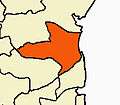 | |
|---|---|---|
| Country | ||
| State | ||
| Region | ||
| Taluks | ||
| Blocks | ||
| Municipalities | ||
| Rivers | ||
| Lakes | ||
| History | ||
| Places of interest | ||
| Universities | ||