Vellar River
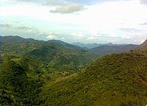
Vellar is a river which originates in the Shevaroy Hills and runs through the districts of Salem, Perambalur and Cuddalore in the northern part of the Indian state of Tamil Nadu before draining into the Bay of Bengal near Parangipettai.
The total length of the Vellar river is about 150 kilometres (93 mi). The total area of the basin is 7,520.87 square kilometres (2,903.82 sq mi). The Vellar river basin is in the northern part of Tamil Nadu State in South India, between the latitudes 11° 13'N - 12 00' N and longitude 78° 13'E - 79° 47 E. This basin is between the Ponnaiar, Paravanar and Cauvery river basins. The terrain lying in the Kalrayan hills, Attur Taluk of Salem District is drained by river upper velar, Vasis ta Nadhi known as Upper Vellar joined with to form the Vellar in the Perambalur Taluk of Permabalur District.
Tributaries
The river Vellar has six named tributaries. They are Anaimaduvu, Swethanadhi, Kallar, Chinnar, Manimukthanadhi, and Gomukhi.
A portion of Dharmapuri, Salem, Namakkal, Perambalur, Trichy, Villupuram and Cuddalore districts fall within the Vellar river basin. Manimukthanadhi, which is the major tributary, also originates from Kalrayan hills in Villupuram district, traverses about 111 kilometres (69 mi) and joins Vellar near Srimushnam in Chidambararm taluk of Cuddalore District. Upper Vellar drains the water from the southern slopes of the Kalrayan hills on the northern boundary of Attur Taluk of Salem district. It originates at an elevation of 1,266 metres (4,154 ft) above mean sea level. At its starting point, it is known as Anaimaduvu River and flows southwards for 23 kilometres (14 mi) and then south-east.
One reservoir constructed across Anaimaduvu River is called Anaimaduvu reservoir. Just 3 kilometres (1.9 mi) below this point another tributary known as Thumbal River, formed by two drainages viz., Karyakoil river and Ammapalayam river flowing southwards from Kottaipatti pass on the Kalrayan hills, joins on the left flank. Another stream called Periyar originating in Jalluthu Reserve forest just 8 kilometres (5 mi) east of Salem taluk joins this stream. As Periyar River approaches Salem - Attur road it bends eastwards and receives on the south, the Singipuram River. Vasistanadi then flows towards southeast for about 26 kilometres (16 mi) along with boundary between Attur and Perambalur Taluk of Perambalur district on the one aide and Vridhachalam taluk of Cuddalore district on the other.
Near Peraiyur in the Perambalur taluk, it is joined by Swetanadhi 4 kilometres (2.5 mi) to the west of the Chennai–Trichy National Highway near Tholudur in Cuddalore district. In the reach between the confluence points of Singipuram and Swetanadhi with Vasistanadhi, the tributaries Kallar and Saval Odai join the main river: on the left flank and Chittar, Koraiyar, Manjani Odai and Ellar Odai on the flank join the Vasistanadhi. The drainage area up to the confluence with the Swetanadhi is 1,772 square kilometres (684 sq mi). An area of 10,572 hectares (26,120 acres) is irrigated through 70 tanks and 79 anicuts.
Vellar Flood in 2015
The River Vellar has been flooded in the parts of Cuddalore due to the heavy rainfall in Tamil Nadu in the November and December months of 2015.
See also


| District Headquarters |  | |
|---|---|---|
| Country | ||
| State | ||
| Region | ||
| Divisions |
| |
| Taluks | ||
| Villages | ||
| Revenue blocks | ||
| Municipalities | ||
| Rivers | ||
| History | ||
| Places of interest | ||
| ||