Soda Lake (San Bernardino County)
| Soda Lake | |
|---|---|
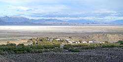 Soda Lake, San Bernardino County, California. Zzyzx and the Desert Studies Center in the foreground. | |
| Location |
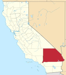
Mojave National Preserve San Bernardino County, California |
| Coordinates | 35°09′55″N 116°04′17″W / 35.16519°N 116.07142°WCoordinates: 35°09′55″N 116°04′17″W / 35.16519°N 116.07142°W |
| Type | Endorheic basin |
| Primary inflows | Mojave River |
| Primary outflows | Terminal (evaporation) |
| Basin countries | United States |
| Max. length | 24 km (15 mi) |
| Max. width | 10 km (6.2 mi) |
| Shore length1 | 75 km (47 mi) |
| Surface elevation | 288 m (945 ft) |
| Settlements |
Baker, California Zzyzx, California |
| References | U.S. Geological Survey Geographic Names Information System: Soda Lake |
| 1 Shore length is not a well-defined measure. | |
Soda Lake (or Soda Dry Lake) is a dry lake at the terminus of the Mojave River[1] in the Mojave Desert of San Bernardino County, California. The lake has standing water during wet periods, and water can be found beneath the surface.
Soda Lake along with Silver Lake are what remains of the large, perennial, Holocene Lake Mojave. The waters of the lake, now with no outlet, evaporate and has left alkaline evaporites of sodium carbonate and sodium bicarbonate.
Soda Lake is located on the southern side of Interstate 15, and can be seen at the Zzyzx Road interchange and the Oat Ditch bridge, as well as the Soda Lake bridge (signed as the Mojave River) looking south from Baker.
See also
References
- USGS (13 January 2004). "Mojave National Preserve: Soda Lake". Geology in the National Parks. U.S. Department of the Interior. Archived from the original on 2007-03-11. Retrieved 2009-09-12.
- Philip Stoffer (14 January 2004). "Changing Climates and Ancient Lakes" (.html). Desert Landforms and Surface Processes in the Mojave National Preserve and Vicinity. Open-File Report 2004-1007. USGS, US Department of the Interior. Retrieved 2009-09-12.
- Philip Stoffer (14 January 2004). "The Mojave River and Associated Lakes" (.html). Desert Landforms and Surface Processes in the Mojave National Preserve and Vicinity. Open-File Report 2004-1007. USGS, US Department of the Interior. Retrieved 2009-09-12.
Footnotes
- ↑ Huegel, Tony (2006-11-15). California Desert Byways: 68 of California's Best Backcountry Drives. Wilderness Press. pp. 106–. ISBN 9780899974132. Retrieved 14 July 2014.
External links
| Wikimedia Commons has media related to Soda Lake (San Bernardino County). |
This article is issued from Wikipedia - version of the 11/26/2016. The text is available under the Creative Commons Attribution/Share Alike but additional terms may apply for the media files.