South Point, Ohio
| South Point, Ohio | |
|---|---|
| Village | |
|
South Point Elementary School | |
 Location of South Point, Ohio | |
 Location of South Point in Lawrence County | |
| Coordinates: 38°25′9″N 82°34′50″W / 38.41917°N 82.58056°WCoordinates: 38°25′9″N 82°34′50″W / 38.41917°N 82.58056°W | |
| Country | United States |
| State | Ohio |
| County | Lawrence |
| Government | |
| • Mayor | Jeff Gaskin |
| Area[1] | |
| • Total | 3.23 sq mi (8.37 km2) |
| • Land | 2.94 sq mi (7.61 km2) |
| • Water | 0.29 sq mi (0.75 km2) |
| Elevation[2] | 564 ft (172 m) |
| Population (2010)[3] | |
| • Total | 3,958 |
| • Estimate (2012[4]) | 3,958 |
| • Density | 1,346.3/sq mi (519.8/km2) |
| Time zone | Eastern (EST) (UTC-5) |
| • Summer (DST) | EDT (UTC-4) |
| ZIP code | 45680 |
| Area code(s) | 740 |
| FIPS code | 39-73670[5] |
| GNIS feature ID | 1065353[2] |
| Website | http://www.villageofsouthpoint.com/ |

South Point is a village in Lawrence County, Ohio, United States, along the Ohio River. South Point straddles Perry Township and Fayette Township. The population was 3,958 at the 2010 census.
South Point is a part of the Huntington-Ashland, WV-KY-OH, Metropolitan Statistical Area (MSA). As of the 2000 census, the MSA had a population of 288,649.
The village mayor is Jeff Gaskin, who was elected in November 2015. [6]
History
A post office called South Point has been in operation since 1855 in Fayette Township.[7] The village was so named for the fact the southernmost point in the state is contained within its borders.[8] Now considered to be a populated place within South Point,[9] in 1918 the community of North Kenova was located at (38.412, -82.578),[10] so named because it was on the opposite bank of the Ohio River from Kenova, West Virginia.
Geography
South Point is located at 38°25′9″N 82°34′50″W / 38.41917°N 82.58056°W (38.419289, -82.580579).[11] The village lies at the junction point of the three states of Ohio, West Virginia, and Kentucky. Not far from the village lies the southernmost point in the State of Ohio, along the Ohio River less than one mile east of the village's southeast corner.
According to the United States Census Bureau, the village has a total area of 3.23 square miles (8.37 km2), of which 2.94 square miles (7.61 km2) is land and 0.29 square miles (0.75 km2) is water.[1]
Demographics
| Historical population | |||
|---|---|---|---|
| Census | Pop. | %± | |
| 1900 | 281 | — | |
| 1910 | 316 | 12.5% | |
| 1920 | 406 | 28.5% | |
| 1930 | 499 | 22.9% | |
| 1940 | 605 | 21.2% | |
| 1950 | 804 | 32.9% | |
| 1960 | 1,663 | 106.8% | |
| 1970 | 2,910 | 75.0% | |
| 1980 | 3,918 | 34.6% | |
| 1990 | 3,823 | −2.4% | |
| 2000 | 3,742 | −2.1% | |
| 2010 | 3,958 | 5.8% | |
| Est. 2015 | 3,924 | [12] | −0.9% |
2010 census
As of the census[3] of 2010, there were 3,958 people, 1,602 households, and 1,132 families residing in the village. The population density was 1,346.3 inhabitants per square mile (519.8/km2). There were 1,699 housing units at an average density of 577.9 per square mile (223.1/km2). The racial makeup of the village was 94.2% White, 3.2% African American, 0.1% Native American, 0.5% Asian, 0.2% from other races, and 1.8% from two or more races. Hispanic or Latino of any race were 0.4% of the population.
There were 1,602 households of which 33.0% had children under the age of 18 living with them, 53.1% were married couples living together, 12.1% had a female householder with no husband present, 5.5% had a male householder with no wife present, and 29.3% were non-families. 25.4% of all households were made up of individuals and 10.5% had someone living alone who was 65 years of age or older. The average household size was 2.47 and the average family size was 2.92.
The median age in the village was 40.3 years. 23.3% of residents were under the age of 18; 7.4% were between the ages of 18 and 24; 25.2% were from 25 to 44; 26.8% were from 45 to 64; and 17.3% were 65 years of age or older. The gender makeup of the village was 46.8% male and 53.2% female.
2000 census
As of the census[5] of 2000, there were 3,742 people, 1,485 households, and 1,131 families residing in the village. The population density was 1,547.0 people per square mile (597.0/km²). There were 1,564 housing units at an average density of 646.6 per square mile (249.5/km²). The racial makeup of the village was 95.91% White, 2.27% African American, 0.08% Native American, 0.16% Asian, 0.03% Pacific Islander, and 1.55% from two or more races. Hispanic or Latino of any race were 0.32% of the population.
There were 1,485 households out of which 31.0% had children under the age of 18 living with them, 61.8% were married couples living together, 10.2% had a female householder with no husband present, and 23.8% were non-families. 21.1% of all households were made up of individuals and 8.4% had someone living alone who was 65 years of age or older. The average household size was 2.52 and the average family size was 2.89.
In the village the population was spread out with 23.1% under the age of 18, 8.3% from 18 to 24, 27.8% from 25 to 44, 25.5% from 45 to 64, and 15.3% who were 65 years of age or older. The median age was 39 years. For every 100 females there were 89.9 males. For every 100 females age 18 and over, there were 89.4 males.
The median income for a household in the village was $33,110, and the median income for a family was $34,560. Males had a median income of $32,439 versus $21,496 for females. The per capita income for the village was $15,296. About 9.0% of families and 11.3% of the population were below the poverty line, including 17.2% of those under age 18 and 3.7% of those age 65 or over.
Government and politics
The village is managed by a six-member city council, the current members of which include Chuck Austin, Mary Cogan, Mike Lynd, David Moore, Eric Rawlins, and Chris Smith. The elected mayor is Jeff Gaskin.[14]
Education
The South Point Local School District serves the village and nearby unincorporated areas. Beginning in March 2004, the district embarked on a project to construct all new school buildings, including demolishing certain buildings: the location of the old middle and high schools is the location of the new South Point Elementary School, while the location of the new Burlington Elementary School is the same as that of the old.[15]
See also
References
- 1 2 "US Gazetteer files 2010". United States Census Bureau. Archived from the original on 2012-01-24. Retrieved 2013-01-06.
- 1 2 "US Board on Geographic Names". United States Geological Survey. 2007-10-25. Retrieved 2008-01-31.
- 1 2 "American FactFinder". United States Census Bureau. Retrieved 2013-01-06.
- ↑ "Population Estimates". United States Census Bureau. Archived from the original on 2013-06-17. Retrieved 2013-06-17.
- 1 2 "American FactFinder". United States Census Bureau. Archived from the original on 2013-09-11. Retrieved 2008-01-31.
- ↑ Heath Harrison. "Mayor begins term Friday". The Ironton Tribune. Retrieved 25 May 2016.
- ↑ "Post offices". Jim Forte Postal History. Retrieved 20 June 2016.
- ↑ Overman, William Daniel (1958). Ohio Town Names. Akron, OH: Atlantic Press. p. 128.
- ↑ Populated Place: North Kenova (Lawrence County)
- ↑ U.S., World War I Draft Registration Card: Isaac Clifford Stanley
- ↑ "US Gazetteer files: 2010, 2000, and 1990". United States Census Bureau. 2011-02-12. Retrieved 2011-04-23.
- ↑ "Annual Estimates of the Resident Population for Incorporated Places: April 1, 2010 to July 1, 2015". Retrieved July 2, 2016.
- ↑ "Census of Population and Housing". Census.gov. Archived from the original on May 11, 2015. Retrieved June 4, 2015.
- ↑ "Government Information". Village of South Point, Ohio. Retrieved 25 May 2016.
- ↑ Phyllis Noah (2007-07-11). "South Point schools taking shape". The Ironton Tribune. Retrieved 2007-07-25.
External links
Municipalities and communities of Lawrence County, Ohio, United States | ||
|---|---|---|
| City | 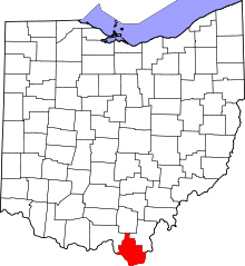 | |
| Villages | ||
| Townships | ||
| CDP | ||
| Unincorporated communities | ||
| Footnotes | ‡This populated place also has portions in an adjacent county or counties | |
| Principal cities |  | |
|---|---|---|
| Municipalities with population over 5,000 | ||
| Municipalities with population 1,000–5,000 | ||
| Municipalities with population under 1,000 | ||
| West Virginia counties | ||
| Kentucky counties | ||
| Ohio counties | ||