Greenup County, Kentucky
| Greenup County, Kentucky | |
|---|---|
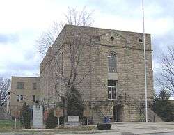 Greenup County courthouse in Greenup | |
 Location in the U.S. state of Kentucky | |
 Kentucky's location in the U.S. | |
| Founded | 1803 |
| Named for | Christopher Greenup |
| Seat | Greenup |
| Largest city | Flatwoods |
| Area | |
| • Total | 354 sq mi (917 km2) |
| • Land | 344 sq mi (891 km2) |
| • Water | 10 sq mi (26 km2), 2.8% |
| Population | |
| • (2010) | 36,910 |
| • Density | 107/sq mi (41/km²) |
| Congressional district | 4th |
| Time zone | Eastern: UTC-5/-4 |
| Website |
greenupcounty |
Greenup County is a county located in the U.S. state of Kentucky. As of the 2010 census, the population was 36,910.[1] The county was founded in 1803 and named in honor of Christopher Greenup.[2] Its county seat is Greenup.[3]
Greenup County is part of the Huntington-Ashland, WV-KY-OH Metropolitan Statistical Area (MSA), as well as the Charleston-Huntington-Ashland, WV-OH-KY Combined Statistical Area. As of the 2010 census, the MSA had a population of 287,702. New definitions from February 28, 2013 placed the population at 363,000.[4]
History
Greenup County was formed by an act of the General Assembly of Kentucky on December 12, 1803 from Mason County which covered the majority of eastern Kentucky at the time.
Three courthouses have served Greenup County.[5] The first courthouse, built of logs, was replaced by a brick structure in 1811.[6]
Law and government
The current officials of Greenup County are:[7]
- County Judge/Executive: Robert W. Carpenter
- County Commissioner: Tony Quillen
- County Commissioner: Billy Stephens
- County Commissioner: Michael Hieneman
- County Attorney: Michael Wilson
- County Coroner: Neil Wright
- County Jailer: Mike Worthington
- County Treasurer: Carol Vinson
- County Sheriff: Keith Cooper
- County Surveyor: Anthony Keibler
- Property Valuation Administrator: Bobby Hall
- County Clerk: Patricia Hieneman
- Circuit Court Clerk: Allen Reed
Greenup County is a part of the 20th Judicial Circuit (general jurisdiction) and the 20th Judicial District (limited jurisdiction) of the Kentucky Court of Justice (the state's unified court system), which also includes neighboring Lewis County. The officials in the 20th Judicial Circuit are: [8] [9]
- Circuit Court, Division 1 (General/Felony Division): Robert B. Conley
- Circuit Court, Division 2 (Family Court Division): Jeffrey L. Preston
- Commonwealth's Attorney (felony prosecutor): Melvin C. Leonhart
The judge in the 20th Judicial District is:
- District Court: Brian C. McCloud
Misdemeanor criminal cases brought in District Court are prosecuted by the County Attorney's office.
Geography
According to the U.S. Census Bureau, the county has a total area of 354 square miles (920 km2), of which 344 square miles (890 km2) is land and 10 square miles (26 km2) (2.8%) is water.[10]
Features
Like most eastern Kentucky counties, Greenup County is predominantly made up of rolling hills and valleys. The land in the Ohio River valley is generally flat and mostly populated by industry, commerce and residential development. Beyond this the land gives way to a series of hills and valleys that are representative of the foothills of the Appalachian Mountains and is relatively sparsely inhabited by farmers. Among these hills, popular fishing spots can be found among the Little Sandy River, Greenbo Lake, and Tygarts Creek. Greenup County's land is still predominantly covered by forest with minimal clear cutting of the old forests.
Greenup County's soil has long been supportive of a healthy agriculture and livestock industry. Traditionally, this has meant a sizeable tobacco base and cattle ranching, but in recent years, as traditional agriculture products have come under the dominance of agri-corporations, growth has been seen in non-traditional products such as American Quarter Horses, ostriches, and marijuana.
Major highways
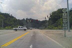
U.S. Highway 23 is the primary route for travel through Greenup County. It enters Greenup County at the southeastern most point and follows the Ohio River north along the eastern border passing through Russell, Flatwoods, Raceland, Wurtland, and Greenup. It then exits just west of South Shore crossing the Ohio River again via the U.S. Grant Bridge into Portsmouth, Ohio and continuing north towards Columbus, Ohio.
The AA Highway begins at U.S. Highway 23 and connects to U.S. Highway 52 via the Jesse Stuart Memorial Bridge. The AA Highway (also known as Route 10) runs west intersecting Route 7 and eventually exiting west into Lewis County. Since its completion in 1995, the AA Highway has allowed Northeastern Kentucky residents to more easily travel to Maysville, Kentucky as well as Northern Kentucky and Cincinnati, Ohio.
The northern terminus of the Industrial Parkway (Kentucky Route 67) ends at U.S. Highway 23 at Wurtland. This highway serves to connect Wurtland and the surrounding towns of Greenup, Flatwoods and the unincorporated area of Argillite to the EastPark industrial park and Interstate 64 in Carter County.
Adjacent counties
- Boyd County (southeast)
- Carter County (southwest)
- Lewis County (west)
- Scioto County, Ohio (north)
- Lawrence County, Ohio (east)
Demographics
| Historical population | |||
|---|---|---|---|
| Census | Pop. | %± | |
| 1810 | 2,369 | — | |
| 1820 | 4,311 | 82.0% | |
| 1830 | 5,852 | 35.7% | |
| 1840 | 6,297 | 7.6% | |
| 1850 | 9,654 | 53.3% | |
| 1860 | 8,760 | −9.3% | |
| 1870 | 11,463 | 30.9% | |
| 1880 | 13,371 | 16.6% | |
| 1890 | 11,911 | −10.9% | |
| 1900 | 15,432 | 29.6% | |
| 1910 | 18,475 | 19.7% | |
| 1920 | 20,062 | 8.6% | |
| 1930 | 24,554 | 22.4% | |
| 1940 | 24,971 | 1.7% | |
| 1950 | 24,887 | −0.3% | |
| 1960 | 29,238 | 17.5% | |
| 1970 | 33,192 | 13.5% | |
| 1980 | 39,132 | 17.9% | |
| 1990 | 36,742 | −6.1% | |
| 2000 | 36,891 | 0.4% | |
| 2010 | 36,910 | 0.1% | |
| Est. 2015 | 36,068 | [11] | −2.3% |
| U.S. Decennial Census[12] 1790-1960[13] 1900-1990[14] 1990-2000[15] 2010-2013[1] | |||
As of the census[16] of 2000, there were 36,891 people, 14,536 households, and 11,032 families residing in the county. The population density was 107 per square mile (41/km2). There were 15,977 housing units at an average density of 46 per square mile (18/km2). The racial makeup of the county was 98.07% White, 0.57% Black or African American, 0.19% Native American, 0.38% Asian, 0.15% from other races, and 0.64% from two or more races. 0.55% of the population were Hispanic or Latino of any race.
There were 14,536 households out of which 32.00% had children under the age of 18 living with them, 62.30% were married couples living together, 10.40% had a female householder with no husband present, and 24.10% were non-families. 21.70% of all households were made up of individuals and 10.00% had someone living alone who was 65 years of age or older. The average household size was 2.51 and the average family size was 2.91.
In the county the population was spread out with 23.60% under the age of 18, 7.90% from 18 to 24, 27.90% from 25 to 44, 26.00% from 45 to 64, and 14.60% who were 65 years of age or older. The median age was 39 years. For every 100 females there were 92.80 males. For every 100 females age 18 and over, there were 89.30 males.
The median income for a household in the county was $32,142, and the median income for a family was $38,928. Males had a median income of $35,475 versus $21,198 for females. The per capita income for the county was $17,137. About 11.60% of families and 14.10% of the population were below the poverty line, including 18.60% of those under age 18 and 9.90% of those age 65 or over.
Politics
| Year | Republican | Democrat |
|---|---|---|
| 2016 | 70.93% 11,546 | 25.47% 4,146 |
| 2012 | 58.38% 8,855 | 39.73% 6,027 |
| 2008 | 56.01% 8,849 | 41.91% 6,621 |
| 2004 | 52.91% 8,696 | 46.43% 7,630 |
| 2000 | 49.33% 7,233 | 48.86% 7,164 |
Education
Public school districts
- Greenup County School District serves the cities of Greenup, Wurtland, South Shore and rural Greenup County.
- Russell Independent School District serves the cities of Russell, Flatwoods and Bellefonte.
- Raceland-Worthington Independent School District serves the cities of Raceland and Worthington.
Places of interest
Alcohol sales
Greenup County is a moist county, meaning that sale of alcohol in the county is prohibited except in certain areas as voted on by the residents of the area, including at least one area where full retail sales are permitted. In the case of Greenup County, alcohol sales are permitted in two areas:
- The city of Russell allows the full retail sale of alcohol after previously allowing by the drink alcohol sales at restaurants which seat at least 100 diners and derive at least 70% of their total sales from food.
- The Bellefonte Country Club in the city of Bellefonte allows alcohol sales under a provision that allows voters of an otherwise dry precinct to allow alcohol sales at a specific, voter approved, USGA regulation golf course.[18]
Communities
- Bellefonte
- Flatwoods
- Greenup (county seat)
- Raceland
- Russell
- South Shore
- Worthington
- Wurtland
Notable residents
- Billy Ray Cyrus - singer/actor, son of Ron Cyrus and father of Miley Cyrus
- Ron Cyrus - politician
- Don Gullett - Major League Baseball pitcher
- Herb Roe - mural artist
- John Stephenson - Major League Baseball player
- Jesse Stuart - Kentucky Poet Laureate
- Clint "Hawk" Thomas - baseball player for the New York Black Yankees of the Negro League
See also
References
- 1 2 "State & County QuickFacts". United States Census Bureau. Retrieved March 6, 2014.
- ↑ http://www.kyenc.org/entry/g/GREEN06.html
- ↑ "Find a County". National Association of Counties. Retrieved 2011-06-07.
- ↑ "Population statistics" (PDF).
- ↑ Hogan, Roseann Reinemuth (1992). Kentucky Ancestry: A Guide to Genealogical and Historical Research. Ancestry Publishing. p. 243. Retrieved 26 July 2013.
- ↑ Federal Writers' Project (1996). The WPA Guide to Kentucky. University Press of Kentucky. p. 234. Retrieved 24 November 2013.
- ↑ "Greenup County Departments". Greenup Country Fiscal Court. Retrieved 2015-09-30.
- ↑ Kentucky Court of Justice
- ↑ Office of the Attorney General - Commonwealth's and County Attorneys
- ↑ "2010 Census Gazetteer Files". United States Census Bureau. August 22, 2012. Retrieved August 14, 2014.
- ↑ "County Totals Dataset: Population, Population Change and Estimated Components of Population Change: April 1, 2010 to July 1, 2015". Retrieved July 2, 2016.
- ↑ "U.S. Decennial Census". United States Census Bureau. Retrieved August 14, 2014.
- ↑ "Historical Census Browser". University of Virginia Library. Retrieved August 14, 2014.
- ↑ "Population of Counties by Decennial Census: 1900 to 1990". United States Census Bureau. Retrieved August 14, 2014.
- ↑ "Census 2000 PHC-T-4. Ranking Tables for Counties: 1990 and 2000" (PDF). United States Census Bureau. Retrieved August 14, 2014.
- ↑ "American FactFinder". United States Census Bureau. Retrieved 2008-01-31.
- ↑ "Dave Leip's Atlas of U.S. Presidential Elections". Retrieved 2016-04-13.
- ↑ Wet and Dry Counties in Kentucky as of 7/12/2010
External links
- Government website
- The Kentucky Highlands Project
- Detailed Road Map of Greenup County
- Greenup County Tourism and Convention Commission
Municipalities and communities of Greenup County, Kentucky, United States | ||
|---|---|---|
| Cities | | |
| Unincorporated communities | ||
| Principal cities | 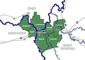 | |
|---|---|---|
| Municipalities with population over 5,000 | ||
| Municipalities with population 1,000–5,000 | ||
| Municipalities with population under 1,000 | ||
| West Virginia counties | ||
| Kentucky counties | ||
| Ohio counties | ||

Coordinates: 38°32′N 82°55′W / 38.54°N 82.92°W