Barboursville, West Virginia
| Barboursville, West Virginia | |
|---|---|
| Village | |
|
Main Street in Barboursville in 2007 | |
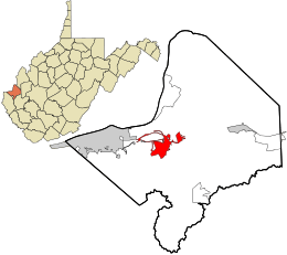 Location in Cabell County and the state of West Virginia. | |
| Coordinates: 38°24′40″N 82°17′52″W / 38.41111°N 82.29778°WCoordinates: 38°24′40″N 82°17′52″W / 38.41111°N 82.29778°W | |
| Country | United States |
| State | West Virginia |
| County | Cabell |
| Area[1] | |
| • Total | 4.19 sq mi (10.85 km2) |
| • Land | 4.09 sq mi (10.59 km2) |
| • Water | 0.10 sq mi (0.26 km2) |
| Elevation | 581 ft (177 m) |
| Population (2010)[2] | |
| • Total | 3,964 |
| • Estimate (2012[3]) | 4,065 |
| • Density | 969.2/sq mi (374.2/km2) |
| Time zone | Eastern (EST) (UTC-5) |
| • Summer (DST) | EDT (UTC-4) |
| ZIP code | 25504 |
| Area code(s) | 304 |
| FIPS code | 54-04276[4] |
| GNIS feature ID | 1553799[5] |

Barboursville is a village in Cabell County, West Virginia, United States. It is located near the second largest city in the state, Huntington. The population was 3,964 at the 2010 census.
Barboursville is a part of the Huntington-Ashland, WV-KY-OH, Metropolitan Statistical Area (MSA). As of the 2010 census, the MSA had a population of 287,702. New definitions from February 28, 2013 placed the population at 363,000.[6]
History
Barboursville was platted in 1813.[7]
The Barboursville Historic District was listed on the National Register of Historic Places in 2008. The Thornburg House was separately listed in 1991.[8]
Geography
Barboursville is located at 38°24′40″N 82°17′52″W / 38.41111°N 82.29778°W (38.411002, -82.297758).[9] According to the United States Census Bureau, the village has a total area of 4.19 square miles (10.85 km2), of which, 4.09 square miles (10.59 km2) is land and 0.10 square miles (0.26 km2) is water.[1] The confluence of the Mud River and the Guyandotte River is just north of the village.
Demographics
| Historical population | |||
|---|---|---|---|
| Census | Pop. | %± | |
| 1860 | 341 | — | |
| 1870 | 371 | 8.8% | |
| 1880 | 361 | −2.7% | |
| 1900 | 429 | — | |
| 1910 | 907 | 111.4% | |
| 1920 | 974 | 7.4% | |
| 1930 | 1,508 | 54.8% | |
| 1940 | 1,550 | 2.8% | |
| 1950 | 1,943 | 25.4% | |
| 1960 | 2,331 | 20.0% | |
| 1970 | 2,279 | −2.2% | |
| 1980 | 2,871 | 26.0% | |
| 1990 | 2,774 | −3.4% | |
| 2000 | 3,183 | 14.7% | |
| 2010 | 3,964 | 24.5% | |
| Est. 2015 | 4,069 | [10] | 2.6% |
2010 census
As of the census[2] of 2010, there were 3,964 people, 1,528 households, and 904 families residing in the village. The population density was 969.2 inhabitants per square mile (374.2/km2). There were 1,625 housing units at an average density of 397.3 per square mile (153.4/km2). The racial makeup of the village was 94.1% White, 3.1% African American, 0.2% Native American, 1.3% Asian, 0.1% from other races, and 1.2% from two or more races. Hispanic or Latino of any race were 0.7% of the population.
There were 1,528 households of which 25.3% had children under the age of 18 living with them, 43.2% were married couples living together, 11.9% had a female householder with no husband present, 4.1% had a male householder with no wife present, and 40.8% were non-families. 36.4% of all households were made up of individuals and 14.6% had someone living alone who was 65 years of age or older. The average household size was 2.12 and the average family size was 2.76.
The median age in the village was 38.8 years. 16.8% of residents were under the age of 18; 9.3% were between the ages of 18 and 24; 30.4% were from 25 to 44; 25.8% were from 45 to 64; and 17.5% were 65 years of age or older. The gender makeup of the village was 52.7% male and 47.3% female.
2000 census
As of the census[4] of 2000, there were 3,183 people, 1,365 households, and 877 families residing in the village. The population density was 864.1 people per square mile (334.0/km²). There were 1,465 housing units at an average density of 397.7 per square mile (153.7/km²). The racial makeup of the village was 97.77% White, 0.82% African American, 0.16% Native American, 0.60% Asian, 0.06% Pacific Islander, 0.06% from other races, and 0.53% from two or more races. Hispanic or Latino of any race were 0.72% of the population.
There were 1,365 households out of which 25.9% had children under the age of 18 living with them, 51.1% were married couples living together, 10.5% had a female householder with no husband present, and 35.7% were non-families. 31.2% of all households were made up of individuals and 14.1% had someone living alone who was 65 years of age or older. The average household size was 2.25 and the average family size was 2.82.
In the village the population was spread out with 19.4% under the age of 18, 9.9% from 18 to 24, 26.1% from 25 to 44, 27.2% from 45 to 64, and 17.5% who were 65 years of age or older. The median age was 42 years. For every 100 females there were 94.4 males. For every 100 females age 18 and over, there were 90.7 males.
The median income for a household in the village was $35,139, and the median income for a family was $45,167. Males had a median income of $32,952 versus $26,469 for females. The per capita income for the village was $19,848. About 5.4% of families and 10.0% of the population were below the poverty line, including 8.5% of those under age 18 and 7.1% of those age 65 or over.
Commerce
Barboursville is home to the Huntington Mall.
Emergency services
Thanks to the tax base afforded by the Huntington Mall, the Village of Barboursville can afford a high degree of police protection. Fire services are provided by a volunteer fire department. Medical transport is provided by the county EMS. There are two hospitals in the nearby City of Huntington, St. Mary's and Cabell Huntington.
Education
Young people in Barboursville are educated by the schools of the Cabell County Board of Education. In 1994 the Board consolidated most of its schools into a few large facilities. Primary education is given at Village of Barboursville Elementary, which is a consolidation of Pea Ridge Elementary and Barboursville Elementary. High school students began attending Cabell Midland High School, a facility resulting from the consolidation of Barboursville High School and Milton High School, in the fall of 1994. Cabell Midland High School is in Ona, about five miles east of Barboursville.
Technical and trade education for Barboursville public school students is administered by the Cabell County Career Technology Center in Huntington; the CCCTC offers courses in automotive mechanics, HVAC, welding, nursing, and information technology. Classes are also available to adults as college-level courses.
University courses are available through Marshall University and Mountwest Community & Technical College in Huntington; the majority of college-bound students in Barboursville attend college.
Landmarks
There is a "trail" through Barboursville that showcases many of its historic buildings. One such structure is an old toll house dating to the pre-Civil War era. Other landmarks include the Veterans' Home, Barboursville Elementary and Middle Schools (both schools have been rebuilt), and Barboursville Park, which serves as a popular recreation area for residents of the area.
Barboursville is located near US Route 60, which follows the route of the historic Midland Trail.
Traditions
Barboursville has a Fall Fest each year. This was formerly known as Oktoberfest, after the German model. A temporary fair-ground is set up across the Guyandotte River, on the old Sadler field before the bridge into the town, and offers a variety of amusements for the locals. Along with Fall Fest, Barboursville has a parade to begin the activities.
On the evening of Independence Day, Barboursville hosts a free fireworks display for the locals. Shortly after nightfall in Barboursville Park, the fireworks display is fired from the highest hill in the park.
Halloween trick or treating is traditionally held on October 30 in Barboursville, though the date is set by the city council and therefore subject to change. Trick or treating hours are held between 6 pm and 8 pm.
References
- 1 2 "US Gazetteer files 2010". United States Census Bureau. Archived from the original on January 24, 2012. Retrieved 2013-01-24.
- 1 2 "American FactFinder". United States Census Bureau. Retrieved 2013-01-24.
- ↑ "Population Estimates". United States Census Bureau. Archived from the original on June 17, 2013. Retrieved 2013-06-26.
- 1 2 "American FactFinder". United States Census Bureau. Archived from the original on September 11, 2013. Retrieved 2008-01-31.
- ↑ "US Board on Geographic Names". United States Geological Survey. 2007-10-25. Retrieved 2008-01-31.
- ↑ "Population statistics" (PDF).
- ↑ Kenny, Hamill (1945). West Virginia Place Names: Their Origin and Meaning, Including the Nomenclature of the Streams and Mountains. Piedmont, WV: The Place Name Press. p. 94.
- ↑ National Park Service (2010-07-09). "National Register Information System". National Register of Historic Places. National Park Service.
- ↑ "US Gazetteer files: 2010, 2000, and 1990". United States Census Bureau. 2011-02-12. Retrieved 2011-04-23.
- ↑ "Annual Estimates of the Resident Population for Incorporated Places: April 1, 2010 to July 1, 2015". Retrieved July 2, 2016.
- ↑ "Census of Population and Housing". Census.gov. Archived from the original on May 11, 2015. Retrieved June 4, 2015.
Municipalities and communities of Cabell County, West Virginia, United States | ||
|---|---|---|
| City | 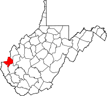 | |
| Town | ||
| Village | ||
| CDPs | ||
| Other communities | ||
| Footnotes | ‡This populated place also has portions in an adjacent county or counties | |
| Principal cities | 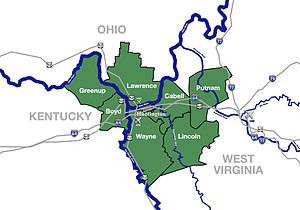 | |
|---|---|---|
| Municipalities with population over 5,000 | ||
| Municipalities with population 1,000–5,000 | ||
| Municipalities with population under 1,000 | ||
| West Virginia counties | ||
| Kentucky counties | ||
| Ohio counties | ||