Tampa, Kansas
| Tampa, Kansas | |
|---|---|
| City | |
 Location within Marion County and Kansas | |
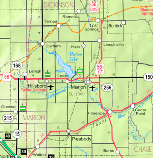 KDOT map of Marion County (legend) | |
| Coordinates: 38°32′55″N 97°9′18″W / 38.54861°N 97.15500°WCoordinates: 38°32′55″N 97°9′18″W / 38.54861°N 97.15500°W[1] | |
| Country | United States |
| State | Kansas |
| County | Marion |
| Platted | 1887 |
| Incorporated | 1908 |
| Government | |
| • Type | Mayor–Council |
| • Mayor | Timothy Svoboda [2] |
| • City Clerk | Donna Backhus [2] |
| Area[3] | |
| • Total | 0.18 sq mi (0.47 km2) |
| • Land | 0.18 sq mi (0.47 km2) |
| • Water | 0 sq mi (0 km2) |
| Elevation[1] | 1,424 ft (434 m) |
| Population (2010)[4] | |
| • Total | 112 |
| • Estimate (2015)[5] | 107 |
| • Density | 620/sq mi (240/km2) |
| Time zone | CST (UTC-6) |
| • Summer (DST) | CDT (UTC-5) |
| ZIP code | 67483 |
| Area code | 785 |
| FIPS code | 20-70000 [1] |
| GNIS feature ID | 0477122 [1] |
|
| |
Tampa is a city in Marion County, Kansas, United States.[1][6] As of the 2010 census, the city population was 112.[7]
History
Early history
For many millennia, the Great Plains of North America was inhabited by nomadic Native Americans. From the 16th century to 18th century, the Kingdom of France claimed ownership of large parts of North America. In 1762, after the French and Indian War, France secretly ceded New France to Spain, per the Treaty of Fontainebleau.
19th century
In 1802, Spain returned most of the land to France. In 1803, most of the land for modern day Kansas was acquired by the United States from France as part of the 828,000 square mile Louisiana Purchase for 2.83 cents per acre.
From the 1820s to the 1870s, one of the most significant land routes in the United States was the Santa Fe Trail. It was located along the edge of what would become Tampa. Two Santa Fe Trail markers were located on the trail near Tampa.[8] The trail was active across Marion County from 1821 to 1866.[9]
In 1854, the Kansas Territory was organized, then in 1861 Kansas became the 34th U.S. state. In 1855, Marion County was established within the Kansas Territory, which included the land for modern day Tampa.[10]
In 1887, the Chicago, Kansas and Nebraska Railway built a main line from Herington through Tampa to Pratt.[11] In 1888, this line was extended to Liberal. Later, it was extended to Tucumcari, New Mexico and El Paso, Texas. It foreclosed in 1891 and taken over by Chicago, Rock Island and Pacific Railway, which shut down in 1980 and reorganized as Oklahoma, Kansas and Texas Railroad, merged in 1988 with Missouri Pacific Railroad, and finally merged in 1997 with Union Pacific Railroad. Most locals still refer to this railroad as the "Rock Island".
The Golden Belt Town Company filed the plat for Tampa in 1887. The source of the city name is said to have been suggested by a railroad engineer who rode one of the first trains through Tampa. Tampa was incorporated as a city in 1908.[12][13]
A post office was established in Tampa on April 17, 1888.[14]
Geography
Tampa is located at 38°32′55″N 97°9′18″W / 38.54861°N 97.15500°W (38.548493, −97.154893).[1] According to the United States Census Bureau, the city has a total area of 0.18 square miles (0.47 km2), all of it land.[3]
Area attractions
Tampa has one building listed on the National Register of Historic Places (NRHP).
- 1910 P.H. Meehan House (NRHP), 401 North Columbus Street. Not open to public.
- Santa Fe Trail[15]
- Santa Fe Trail Markers, numerous markers in the area.
- Santa Fe Trail Self-Guided Auto Tour.
Demographics
| Historical population | |||
|---|---|---|---|
| Census | Pop. | %± | |
| 1910 | 256 | — | |
| 1920 | 262 | 2.3% | |
| 1930 | 275 | 5.0% | |
| 1940 | 222 | −19.3% | |
| 1950 | 216 | −2.7% | |
| 1960 | 145 | −32.9% | |
| 1970 | 154 | 6.2% | |
| 1980 | 113 | −26.6% | |
| 1990 | 113 | 0.0% | |
| 2000 | 144 | 27.4% | |
| 2010 | 112 | −22.2% | |
| Est. 2015 | 107 | [5] | −4.5% |
| U.S. Decennial Census | |||
2010 census
As of the census[4] of 2010, there were 112 people, 48 households, and 27 families residing in the city. The population density was 622.2 inhabitants per square mile (240.2/km2). There were 67 housing units at an average density of 372.2 per square mile (143.7/km2). The racial makeup of the city was 98.2% White and 1.8% Native American. Hispanic or Latino of any race were 0.9% of the population.
There were 48 households of which 22.9% had children under the age of 18 living with them, 50.0% were married couples living together, 6.3% had a female householder with no husband present, and 43.8% were non-families. 43.8% of all households were made up of individuals and 23% had someone living alone who was 65 years of age or older. The average household size was 2.33 and the average family size was 3.19.
The median age in the city was 45 years. 28.6% of residents were under the age of 18; 5.4% were between the ages of 18 and 24; 16.1% were from 25 to 44; 23.2% were from 45 to 64; and 26.8% were 65 years of age or older. The gender makeup of the city was 58.9% male and 41.1% female.
2000 census
As of the census[16] of 2000, there were 144 people, 59 households, and 37 families residing in the city. The population density was 736.5 people per square mile (278.0/km²). There were 69 housing units at an average density of 352.9 per square mile (133.2/km²). The racial makeup of the city was 93.06% White, and 6.94% from two or more races. Hispanic or Latino of any race were 9.03% of the population.
There were 59 households out of which 30.5% had children under the age of 18 living with them, 50.8% were married couples living together, 11.9% had a female householder with no husband present, and 35.6% were non-families. 33.9% of all households were made up of individuals and 25.4% had someone living alone who was 65 years of age or older. The average household size was 2.44 and the average family size was 3.21.
In the city the population was spread out with 30.6% under the age of 18, 6.9% from 18 to 24, 21.5% from 25 to 44, 16.7% from 45 to 64, and 24.3% who were 65 years of age or older. The median age was 36 years. For every 100 females there were 105.7 males. For every 100 females age 18 and over, there were 88.7 males.
As of 2000 the median income for a household in the city was $18,125, and the median income for a family was $42,083. Males had a median income of $25,000 versus $23,125 for females. The per capita income for the city was $12,677. There were 6.9% of families and 15.6% of the population living below the poverty line, including 25.7% of under eighteens and 11.1% of those over 64.
Government
The Tampa government consists of a mayor and five council members. The council meets the 1st Monday of each month at 7PM (winter) or 8PM (summer).[2]
- City Hall, 113 W 3rd.
- Fire Department, 302 N Main St.
Education
Primary and secondary education
Tampa is part of Unified School District 397.[17][18] The high school is a member of T.E.E.N., a shared video teaching network between five area high schools.[19] All students attend schools in Lost Springs area.
- Centre High School, located south of Lost Springs.
- Centre Junior High School, located south of Lost Springs.
- Centre Middle School, located south of Lost Springs.
- Centre Grade School, located in Lost Springs.
Infrastructure
Transportation
The K-15 highway is 3.75 mi W of the city. Tampa is served by the Union Pacific Railroad, formerly the Southern Pacific, and formerly the Chicago, Rock Island and Pacific Railroad. Tampa is located on UP's Golden State main line to El Paso, Texas and still serves the Tampa Elevator during summer harvests.
Utilities
- Internet
- TV
- Fiber Optics is provided by TCT.
- Satellite is provided by DirecTV, Dish Network.
- Terrestrial is provided by regional digital TV stations.
- Telephone
- Fiber Optics is provided by TCT.
- Electricity
- Rural is provided by Flint Hills RECA.
- Water
- Rural is provided by Marion County RWD #1.
See also
- Blaine Township, Marion County, Kansas (location of Tampa)
- National Register of Historic Places listings in Marion County, Kansas
- Historical Maps of Marion County, Kansas
- 1953 Flint–Worcester tornado outbreak sequence
Further reading
- Tampa
- A History of Tampa, Kansas, and Its Environs, 1887–1987; Tampa Centennial Committee; 1986.
- Santa Fe Trail
- Marion County Auto Tour of the Santa Fe Trail; 2 pages. (Download 1MB PDF Flyer)
- The Story of the Marking of the Santa Fe Trail by the Daughters of the American Revolution in Kansas and the State of Kansas; Almira Cordry; Crane Co; 164 pages; 1915. (Download 4MB PDF eBook)
References
- 1 2 3 4 5 6 Geographic Names Information System (GNIS) details for Tampa, Kansas; United States Geological Survey (USGS); October 13, 1978.
- 1 2 3 "Tampa – Directory of Kansas Public Officials". lkm.org. Retrieved 4 September 2015.
- 1 2 "US Gazetteer files 2010". United States Census Bureau. Retrieved 2012-07-06.
- 1 2 "American FactFinder". United States Census Bureau. Retrieved 2012-07-06.
- 1 2 "Annual Estimates of the Resident Population for Incorporated Places: April 1, 2010 to July 1, 2015". Retrieved July 2, 2016.
- ↑ "HughesNet Gen4 Internet – Unlimited Satellite Internet – Skyways". skyways.org. Retrieved 4 September 2015.
- ↑ "2010 City Population and Housing Occupancy Status". U.S. Census Bureau. Retrieved March 6, 2011.
- ↑ Santa Fe Trail Research Site Larry and Carolyn Mix. "Santa Fe Trail DAR Marker Location in Kansas 1997 Survey". santafetrailresearch.com. Retrieved 4 September 2015.
- ↑ "Official Santa Fe Trail Association". santafetrail.org. Retrieved 4 September 2015.
- ↑ The History of Marion County and Courthouse
- ↑ "Rock Island's Family Tree – Page 4". covad.net. Retrieved 4 September 2015.
- ↑ Marion County Kansas, Past and Present; Sondra Van Meter; 1972.
- ↑ Blackmar, Frank Wilson (1912). Kansas: A Cyclopedia of State History, Volume 2. Standard Publishing Company. p. 796.
- ↑ "Kansas Post Offices, 1828–1961 (archived)". Kansas Historical Society. Archived from the original on October 9, 2013. Retrieved 14 June 2014.
- ↑ Santa Fe Trail Research Site Larry and Carolyn Mix. "Tampa Kansas in Marion County Kansas". santafetrailresearch.com. Retrieved 4 September 2015.
- ↑ "American FactFinder". United States Census Bureau. Retrieved 2008-01-31.
- ↑ "Centre". usd397.com. Retrieved 4 September 2015.
- ↑ Kansas School District Boundary Map
- ↑ "Technology Excellence in Education NetworkINterlocal #632 – Home". Technology Excellence in Education Network
INterlocal #632. Retrieved 4 September 2015.
External links
| Wikimedia Commons has media related to Tampa, Kansas. |
- City
- City of Tampa, archive of former website
- Tampa – Directory of Public Officials
- Schools
- USD 397, Centre school district for Lincolnville, Lost Springs, Pilsen, Tampa, Ramona, Antelope, Burdick, nearby rural areas of Marion / Morris / Dickinson / Chase Counties
- USD 397 School District Boundary Map, KDOT
- Historical
- 1968 photo of Tampa Rock Island Depot
- Marion County cemetery list, archive of KsGenWeb
- Marion County history bibliography, Marion County school bibliography, Kansas Historical Society
- Maps
- Tampa City Map, KDOT
- Topo Map of Tampa / Durham / Ramona / Dillon / Elmo area, USGS
- Marion County Maps: Current, Historic, KDOT
Municipalities and communities of Marion County, Kansas, United States | ||
|---|---|---|
| Cities | 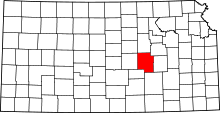 | |
| Unincorporated communities | ||
| Ghost towns | ||
| Townships | ||
| Footnotes | ‡This populated place also has portions in an adjacent county or counties | |