Thiruvambady
| Thiruvambady തിരുവമ്പാടി | |
|---|---|
| Town | |
|
Thiruvambady Bus Stand | |
 Thiruvambady  Thiruvambady Location in Kozhikode, Kerala, India | |
| Coordinates: 11°21′39″N 76°00′32″E / 11.36083°N 76.00889°ECoordinates: 11°21′39″N 76°00′32″E / 11.36083°N 76.00889°E | |
| Country |
|
| State | Kerala |
| District | Kozhikode |
| Taluk | Thamarassery |
| Block Panchayat | Koduvally |
| Government | |
| • MP | M.I.Shanavas - Wayanad (Lok Sabha constituency) |
| • MLA | George M Thomas - (Thiruvambady Assembly Constituency) |
| • Panchayath President | P.T Augustin - Thiruvambady Panchayath |
| Population (2011) | |
| • Total | 28,820 |
| Languages | |
| • Official | Malayalam, English |
| Time zone | IST (UTC+5:30) |
| PIN | 673603 |
| Telephone code | 0495 225.... |
| Vehicle registration | KL 57 |
| Sex ratio | 1000:1040 ♂/♀ |
| Literacy | 96% |


Thiruvambady (Malayalam: തിരുവമ്പാടി) is a major hilly town and one of the suburb in the south - eastern side of Kozhikode district in Kerala, India. Thiruvambady is also an Legislative Assembly Constituency which is situated 35 km from Calicut City.
Location
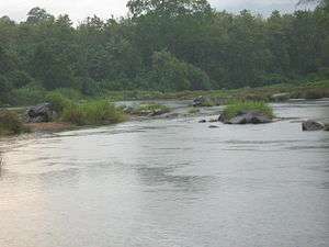
Thiruvambadi is located on the banks of Iruvanjippuzha which is a tributary of Chaliyar situated 35 km far from Kozhikode city. Town is surrounded with mountains, valleys and waterfalls. Famous waterfalls such as Thusharagiri Falls, Arippara Waterfalls, Urumi Hydro Electric Dam Set, Kozhippara Waterfalls Kakkadampoyil, Vellaimala etc.. are situated near to the town.
Transportation
Thiruvambady is well connected by road network with near by places. A KSRTC Bus Operating Centre is situated in town. There is also a private Bus Stand situated in town. The main Bus Services are to nearby places such as Kozhikode, Mukkam, Omassery, Thamarassery, Koduvally, Pulloorampara, Anakkampoyil, Koodaranji and Kodenchery. Also KSRTC buses operates many inter district services from here.
- Nearest Airport - Calicut International Airport is 43 km away. (Karippur - Kondotty - Areekode - Mukkam - Thiruvambady)
- Nearest Railway Station - Kozhikode Railway Station is 35 km away.
How to reach by Road
- Thiruvananthapuram - Kochi - Thrissur - Pattambi - Perinthalmanna - Manjeri - Areacode - Mukkam - Thiruvambady
- Kozhikode - Kunnamangalam - REC (NIT) - Mukkam (Agastianmuzhi) - Thiruvambady
- Kannur - Koyilandy - Thamarassery - Omassery - Thiruvambady
- Wayanad - Adivaram - Kaithappoyil - Kodanchery - Thiruvambady
- Nilambur - Akambadam - Kakkadampoyil - Koombara - Koodaranhi - Thiruvambady
- Koduvally - Omassery - Thiruvambady - Pulloorampara - Anakkampoyil
Distance Chart
The Kilometer chart from Thiruvambady is given below:
| Kozhikode - 35 km | Thamarassery - 15 km |
| Manjeri - 36 km | Mukkam - 6 km |
| Kunnamangalam - 20 km | Koduvally - 12 km |
| Perinthalmanna - 60 km | Areekode - 20 km |
| Palakkad - 122 km | Omassery - 5 km |
| Thrissur - 133 km | Anakkampoyil - 13 km |
| Ernakulam - 202 km | Koodaranji - 5 km |
| Thiruvananthapuram - 414 km | Kodencheri - 10 km |
| Kannur - 113 km | Pulloorampara - 8 km |
| Kalpetta - 53 km | Kakkadampoyil - 19 km |
| Nilambur - 50 km | Punnackal - 5 km |
| Koyilandy - 43 km | Thusharagiri Falls - 18 km |
History
The early Thiruvambady village was a forest area in Kozhikode taluk from Neeleshwaram to Wayanad ghat. After death of Pazhassi Raja against British Army in 1805 this area belonged to East India Company. In this time the land of Zamorin in Kozhikode also belonged to East India Company. East India Company's Malabar area then after belonged to Madras Presidency and was ruled by British. British divide this whole land to small providences, districts and taluks for the ease of ruling. Like that Thiruvambady area came under Kozhikode Taluk. At that time the domain of land in people living area in Thiruvambady was given to Kottayam King Kalppakassery Karnoru and forest area's domain of land was given to Manniledathu Nair Tharavadu. From this squire (Janmikal) the tenants (Kudiyanmar) got agriculture permission in Thiruvambady. People of Thiruvambady cast their first votes to the Malabar district Board and voting rights were only for those who pay tax. The first man who started business in Thiruvambady was late Kuttiassan belonged to Cheruvadi. The second phase of the history of Thiruvambady begun in the year 1944,due to the immigration of people from Travancore area. Second world war and its aftermath severe poverty led them to immigrates them new pastures. Though there was a school named "Nandanassery school" opportunity only to study up to 4th standard was there. Teachers from distant places stayed in the houses of the landlord and taught. Their salary was a small amount of money and food . A little bit of help was there from the Madras Government there.
The immigration of people from Travancore gave new life to Thiruvambady. The immigration of Christians to Thiruvambady started in the year 1942 and Sacred Heart Church was established in the year 1944. Sacred Heart Upper Primary School was started in the year 1947. In the year 1951 Sree Narayana Mission begun Lower Primary School. It is to be noted that there begun a public library in the middle of 1950’s. Thus people of Thiruvambady remember in great respect the contributions rendered by the Christian Missioneries and Sree Narayana Mission forwards progress and development of Thiruvambady.
Etymology
Thiruvambady was known as Nayarukolly. There were two stories about this name. One is that during the Mappila Rebellion,one Appukkuttan Nair was that dead by the army . Another is that this Appukkuttan Nair was killed by a wild elephant. Hence this place is known as Nayarukolly. Now this name is ceased to exit. It is believed that the name 'Thiruvambady' is associated with the Sree Krishna Temple.
Though there were discrimination prevailed between various casts of the Hindu community, no such drifts were with Muslims. Both Hindus and Muslims lived in harmony and there was a lot of co-operation between them. As there were a few Muslims, they had to go to Omassery, Mukkam & Kodiyathur for there Religious get together. The first Mosque in Thiruvanbady arose in the year 1922, under the leadership of late Koyappathody Muhammed kutty. People like Kalpakassery Kutty krishnan Nair,K Kunnikkutty,Rarikkutty, Imbichithiyyan,Arampurath Koru,Palakkadan Koyamu,Imbichi Ahemmed,Thalathil Ummar were actively involved in the national liberation increment. On 15 August 1947, Arampurath Koru hoisted national flag in Thiruvambady.
Demographics
Thiruvambady Gramapanchayath has an area of 20739.44 acres including 9000 acres of forest . There were people living in the area since the beginning of 19th century . As per the record of revenue settlement, then population of Thiruvambady was 531(Hindus-482,Muslims-49). It is said to that Tippu Sultan used to travel through Thiruvambady during the fight of his army. Remnants of the destroyed temples are indication of this. Pazhassi Raja used to live in hiding in Thenpara in Anakkampoyil. Thiruvampady village includes Marakkattupuram and Cherupra area. Cherupra-Marakkattupuram areas are surveyed and the rest the land is unsurveyed.
Economy
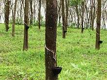
Most people from here are engaged in agriculture and business activities. Hindus, Christians and Muslims co-exist in harmony adding to the diversity in faith and religion. Thiruvambady is one of the major agricultural areas in Kozhikode district. The main cash crops are: rubber, coconut, areca nut, paddy, ginger, turmeric, and pepper. So this area is called as Malayoram. As Thiruvamady is the foot hills of Malayoram, it is one of the major headquarters and towns. Many others are engaged in business and other jobs. Hotels, Restaurants, Petrol pumps, ATM's (SBT, SIB & Federal Bank), Hospitals, Banks, Police Station and other major offices are located in town. A new Hill Highway(SH59) is coming through the town.A new Calicut / Kozhikode International Airport is planned to setup in Thiruvambady Rubber Estate. Upcoming Kerala AIIMS Calicut / Kozhikode also identifies Thiruvambady Rubber Estate as one of the primary land for setting up the Medical College .
Administration
Thiruvambady assembly constituency is part of Wayanad (Lok Sabha constituency). Thiruvambady is also an assembly constituency in Kerala Legislative Assembly having 7 Panchayats. The current MP is M. I. Shanavas and current MLA of Thiruvambady is George M. Thomas. Thiruvambady is a Panchayat having 17 wards of 83.96 sq/km. Thiruvambady is under Koduvally Block Panchayat and Thamarassery Taluk. Thiruvambady Panchayath was established on 1 January 1962 and Thiruvambady Assembly constituency was established on 1977.
Places of interest
- Thusharagiri Falls
- Vellarimala - Wayanad Trucking : Muthappanpuzha - Marippuzha - Olichuchattam - Swargam Kunnu - Vavul Mala - Thenpara - Vellarimala
- Arippara Waterfalls Anakkampoyil
- Kozhippara Waterfalls Kakkadampoyil
- Urumi Hydro Electric Dam Set
- Iruvanjippuzha
Notable people from Thiruvambady
- Late Mathai Chacko - Former MLA & Communist leader
- Jacob Thoomkuzhy - Former Metropolitan Archbishop
Places of Worship
- Sacred Heart Forane Church
- Sree Krishna Temple Ambalappara
- Da'awa Juma Msjid Thiruvambady
- Salafi Msjid Thiruvambady
- Ilanjikkal Devi Temple Thiruvambady
- Bethania Retreat Centre Pullurampara
Educational Institutions
- Sacred Heart HSS Thiruvambady
- Infant Jesus Thiruvambady
- Alphonsa College Thiruvambady
- IHRD College of Applied Science Thiruvambady (Karassery)
- Lisa Nursing School Thiruvambady
- Malabar College Thruvambady
- National Phonix College Thiruvambady
- KMCT Colleges Manassery
- Lisuex Rani Primary School Thiruvambady
- Guidance Public CBSE School Thiruvambady
- Little Kingdom Play School Thiruvambady
- St. Joseph HSS Pulloorampara
- St. Sebastians HSS Koodaranji
- St. Joseph HSS Kodenchery
- St. Sebastians HS Punnackal
- Pallotti Hill Senior Secondary School Mukkam
Hospitals
- Lisa Hospital Thiruvambady
- Santhi Hospital Omassery
- KMCT Medical College Manassery
- Govt. Hospital Thiruvambady
- Veterinary Hospital Thiruvambady
Entertainment
- Harison Theatre Thiruvambady
- Magnus Theatre Thiruvambady
- Abhilash Theatre Mukkam
- Annas Theatre Mukkam
- Pee Cee Theatre Mukkam
- Rose Theatre Agastianmuzhi
- Little Rose Theatre Agastianmuzhi