Transit-oriented development

A transit-oriented development (TOD) is a mixed-use residential and commercial area designed to maximize access to public transport, and often incorporates features to encourage transit ridership while dissuading the ownership of automobiles.[1] A TOD neighborhood typically has a center with a transit station or stop (train station, metro station, tram stop, or bus stop), surrounded by relatively high-density development with progressively lower-density development spreading outward from the center. TODs generally are located within a radius of one-quarter to one-half mile (400 to 800 m) from a transit stop, as this is considered to be an appropriate scale for pedestrians, thus solving the last mile problem.
Description
Many of the new towns created after World War II in Japan, Sweden, and France have many of the characteristics of TOD communities. In a sense, nearly all communities built on reclaimed land in the Netherlands or as exurban developments in Denmark have had the local equivalent of TOD principles integrated in their planning, including the promotion of bicycles for local use.
In the United States, a half-mile-radius circle has become the de facto standard for rail-transit catchment areas for TODs. A half mile (800 m) corresponds to the distance someone can walk in 10 minutes at 3 mph (4.8 km/h) and is a common estimate for the distance people will walk to get to a rail station. The half-mile ring is a little more than 500 acres (2.0 km2) in size.[2]
Transit-oriented development is sometimes distinguished by some planning officials from "transit-proximate development" (see, e.g., comments made during a Congressional hearing [3]) because it contains specific features that are designed to encourage public transport use and differentiate the development from urban sprawl. Examples of these features include mixed-use development that will use transit at all times of day, excellent pedestrian facilities such as high quality pedestrian crossings, narrow streets, and tapering of buildings as they become more distant from the public transport node. Another key feature of transit-oriented development that differentiates it from "transit-proximate development" is reduced amounts of parking for personal vehicles.
Opponents of compact, or transit oriented development typically argue that Americans, and persons throughout the world, prefer low-density living, and that any policies that encourage compact development will result in substantial utility decreases and hence large social welfare costs.[4] Proponents of compact development argue that there are large, often unmeasured benefits of compact development[5] or that the American preference for low-density living is a misinterpretation made possible in part by substantial local government interference in the land market.[6][7]
TOD in cities
Many cities throughout the world are developing TOD policy. Portland, Montreal, San Francisco, and Vancouver among many other cities have developed, and continue to write policies and strategic plans which aim to reduce automobile dependency and increase the use of public transit.
Latin America

Curitiba, Brazil
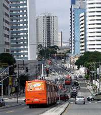
One of the earliest and most successful examples of TOD is Curitiba, Brazil.[8] Curitiba was organized into transport corridors very early on in its history. Over the years, it has integrated its zoning laws and transportation planning to place high-density development adjacent to high-capacity transportation systems, particularly its BRT corridors. Since the failure of its first, rather grandiose, city plan due to lack of funding, Curitiba has focused on working with economical forms of infrastructure, so it has arranged unique adaptations, such as bus routes (inexpensive infrastructure) with routing systems, limited access and speeds similar to subway systems. The source of innovation in Curitiba has been a unique form of participatory city planning that emphasizes public education, discussion and agreement..
Guatemala City, Guatemala
In an attempt to control rapid growth of Guatemala City, the long-time Mayor of Guatemala City Álvaro Arzú implemented a plan to control growth based on transects along important arterial roads and exhibiting transit-oriented development (TOD) characteristics. This plan adopted POT (Plan de Ordenamiento Territorial) aims to allow the construction of taller, mixed-use building structures right by large arterial roads; the buildings would gradually decrease in height and density the farther they are from arterial roads.[9] This is simultaneously being implemented along with a bus rapid transit (BRT) system called Transmetro.
North America
Canada
Calgary, Alberta
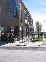
Calgary is home to a very successful TOD community called The Bridges, located in the community of Bridgeland. The Bridges is home to a diverse range of condos, shops, services, and parks. Some other TODs currently being constructed are London and Westbrook, both high rise condo and retail communities in suburban areas of the City. The City continues to create TOD policy for other Calgary communities. Calgary City Council has allocated funding for the creation of six Station Area Plans around the city, to guide increasing development pressure around some of the light rail transit stations. On June 9, 2008, Calgary City Council approved the first station area plan in Calgary's history.
Edmonton, Alberta
Most of the suburban high rises were not along major rail lines like other cities until recently, when there has been incentive to do so. Century Park is a growing condo community in southern Edmonton at the south end of Edmonton's LRT. It will include low to high rise condos, recreational services, shops, restaurants, and a fitness centre. Edmonton has also had a transit-proximate development for some time in the northeastern suburbs at Clareview which includes a large park and ride, and low rise apartments among big box stores and associated power center parking. Edmonton is also looking into some new TODs in various parts of the city. In the northeast, there are plans to redevelop underutilized land at two sites around existing LRT, Fort Road and Stadium Station.[10][11] In the west, there is plans to have some medium density condos in the Glenora neighbourhood along a future LRT route as well as a TOD in the southeast in the Strathearn neighbourhood along the same future LRT on existing low rise apartments.
Montreal, Quebec
According to the Metropolitan Development and Planning Regulation[12] of late 2011, 40% of new households will be build as TOD neighbourhoods.
Toronto, Ontario

Toronto has a longstanding policy of encouraging new construction along the route of its primary Yonge Street subway line. Most notable are the development of the Yonge and Eglinton area in the 1960s and 1970s; and the present development of the 2 km of the Yonge Street corridor north of Sheppard Avenue, which began in the late 1980s. In the period since 1997 alone the latter stretch has seen the appearance of a major new shopping centre and the building and occupation of over twenty thousand new units of condominium housing. Since the opening of the Sheppard subway line in 2002, there is a condominium construction boom along the route on Sheppard Avenue East between Yonge Street and Don Mills Road.
Vancouver, British Columbia
Greater Vancouver has had a strong history of creating new development around its SkyTrain lines and also created the concept of regional town centres on the major stations and transit corridors. Of note is the Metrotown area of the suburb of Burnaby, British Columbia near the Metrotown SkyTrain Station. The areas around stations have spurred the development of billions of dollars of high-density real estate, with multiple highrises near the many stations.
Winnipeg, Manitoba
There is currently one TOD being built in Winnipeg beside the rapid transit corridor. In phase two of the southwest rapid transit corridor, there will be four more TODs.[13]
United States
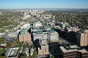
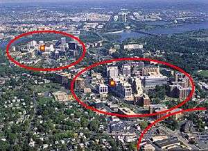
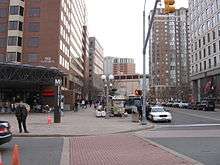
Arlington County, Virginia
For over 30 years, the government has pursed a development strategy of concentrating much of its new development within 1⁄4 to 1⁄2 mile (400 to 800 m) from the County's Washington Metro rapid transit stations and the high-volume bus lines of Columbia Pike.[14] Within the transit areas, the government has a policy of encouraging mixed-use and pedestrian- and transit-oriented development.[15] Some of these "urban village" communities include: Rosslyn, Ballston, Clarendon, Courthouse, Pentagon City, Crystal City, Lyon Village, Shirlington, Virginia Square, and Westover
In 2002, Arlington received the EPA's National Award for Smart Growth Achievement for "Overall Excellence in Smart Growth" — the first ever granted by the agency.[16]
In September 2010, Arlington County, Virginia, in partnership with Washington, D.C., opened Capital Bikeshare, a bicycle sharing system.[17][18][19] By February 2011, Capital Bikeshare had 14 stations in the Pentagon City, Potomac Yard, and Crystal City neighborhoods in Arlington.[17] Arlington County also announced plans to add 30 stations in fall 2011, primarily along the densely populated corridor between the Rosslyn and Ballston neighborhoods, and 30 more in 2012.[20]
Aurora, Colorado
The city has developed within its plan as of 2007 standardization measures. For instance, streets' width has been set according to the position of the site.[21][22]
New Jersey
New Jersey has become a national leader in promoting transit oriented development. The New Jersey Department of Transportation established the Transit Village Initiative in 1999 offering multi-agency assistance and grants from the annual $1 million fund to any municipality with a ready to go project specifying appropriate mixed land-use strategy, available property, station-area management, and commitment to affordable housing, job growth, and culture. Transit village development must also preserve the architectural integrity of historically significant buildings. Since 1999 the state has made 30 Transit Village designations, which are in different stages of development:
Pleasantville (1999), Morristown (1999), Rutherford (1999), South Amboy (1999), South Orange (1999), Riverside (2001), Rahway (2002), Metuchen (2003), Belmar (2003), Bloomfield (2003), Bound Brook (2003), Collingswood (2003), Cranford (2003) Matawan (2003), New Brunswick (2005), Journal Square/Jersey City (2005), Netcong (2005), Midtown Elizabeth (2007), Burlington City (2007), Orange (2009), Montclair (2010), Somerville (2010), Linden (2010), West Windsor (2012), Dunellen (2012), Plainfield (2014), Park Ridge (2015), and Irvington (2015).[23][24]
Pittsburgh, Pennsylvania
The East Liberty neighborhood is nearing completion of a $150 million Transit Oriented Development centered around the reconfigured East Liberty Station on the city's Martin Luther King Jr. East Busway.[25][26] The development included improved access to the station with a new pedestrian bridge and pedestrian walkways that increase the effective walkshed of the station. The East Busway is a fixed guideway route that offers riders an 8-minute ride from East Liberty to Pittsburgh's Downtown.
Salt Lake City Metro Area, Utah
The Salt Lake City Metro Area has seen a strong proliferation of transit-oriented developments due to the construction of new transit lines within the Utah Transit Authority's TRAX, FrontRunner and streetcar lines. New developments in West Valley, Farmington, Murray, Provo, Kaysville, Sugarhouse and downtown Salt Lake City have seen rapid growth and construction despite the economic downturn. The population along the Wasatch Front has reached 1.7 million and is expected to grow 50% over the next two decades. At 29.8%, Utah's population growth more than doubled the population growth of the nation (13.2%), with a vast majority of this growth occurring along the Wasatch Front.
Transportation infrastructure has been vastly upgraded in the past decade as a result of the 2002 Olympic Winter Games and the need to support the growth in population. This has created a number of transit-oriented commercial and residential projects to be proposed and completed.
San Francisco Bay Area, California
The San Francisco Bay Area includes nine counties and 101 cities, including San Jose, San Francisco, Oakland and Fremont. Local and regional governments [27] encourage transit-oriented development to decrease traffic congestion, protect natural areas, promote public health and increase housing options. The region has designated Priority Development Areas and Priority Conservation Areas. Current population forecasts [28] for the region predict that it will grow by 2 million people by 2035 due to both the natural birth rate and job creation, and estimate that 50% of this growth can be accommodated in Priority Development Areas through transit-oriented development.
Major transit village projects have been developed over the past 20 years at several stations linked to the Bay Area Rapid Transit (BART) system. In their 1996 book, Transit Villages in the 21st Century, Michael Bernick and Robert Cervero identified emerging transit villages at several BART stations, including Pleasant Hill / Contra Costa Centre, Fruitvale, Hayward and Richmond.[29]
Asia and Oceania
Hong Kong
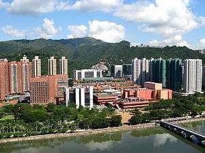
Compared to other developed economies, the car ownership rate in Hong Kong is very low, and approximately 90% of all trips are made by public transport.[30]
In the mid-20th century, no railway was built until an area was well developed. However, in recent decades, Hong Kong has started to have some TODs, where a railway is built simultaneously with residential development above or nearby. Examples include:
Melbourne, Victoria
Melbourne, Victoria is expected to reach a population of 5 million by 2030 with the overwhelming majority of its residents relying on private automobiles. Since the turn of the century, sporadic efforts have been made by various levels of government to implement transit-oriented development principles. However, a lack of commitment to funding public transport infrastructure, resulting to overcrowding and amending zoning laws has dramatically slowed progress toward sustainable development for the city.
Milton, Queensland
Milton, an inner suburb of Brisbane, has been identified as Queensland's first transit-oriented development under the Queensland Government’s South East Queensland Regional Plan. Milton railway station will undergo a multimillion-dollar revamp as part of the development of The Milton Residences to promote and encourage residents to embrace rail travel. This will include a new ticketing office, new public amenities, increased visibility across platforms and new and improved access points off Milton Road and Railway Terrace.[31]
Europe

The term transit-oriented development, as a US-born concept, is rarely used in Europe, although many of the measures advocated in transit-oriented development are also stressed here. Many European cities have long been built around transit systems and there has thus often been little or no need to differentiate this type of development with a special term as has been the case in the US. An example of this is Copenhagen's Finger Plan from 1947, which embodied many transit-oriented development aspects and is still used as an overall planning framework today. Recently, scholars and technicians have taken interest in the concept, however.[32]
Paris, France
Whereas the city of Paris has a centuries-long history, its main frame dates to the 19th century. The subway network was made to solve both linkage between the five main train stations and local transportation assets for citizens. The whole area of Paris City has metro stations no more than 500 metres apart. Recent bicycle and car rental systems (Velib and Autolib) also ease travel, in the very same way that TOD emphasizes.So do the new trams linking suburbs close to Paris proper, and tramline 3 around the edge of the city of Paris.
Stedenbaan, The Netherlands
In the Southern part of the Randstad will be built a neighbourhood according to the principles of TOD.[33]
Equity and housing cost concerns
One criticism of transit-oriented development is that it has the potential to spur gentrification in low-income areas. In some cases, TOD can raise the housing costs of formerly affordable neighborhoods, pushing low- and moderate-income residents farther away from jobs and transit. When this happens, TOD projects can disrupt low-income neighborhoods.[34]
When executed with equity in mind, however, TOD has the potential to benefit low- and moderate-income (LMI) communities: it can link workers to employment centers, create construction and maintenance jobs, and has the potential to encourage investment in areas that have suffered neglect and economic depression.[35] Moreover, it is well recognized that neighborhood development restrictions, while potentially in the immediate neighborhood's best interest, contribute to regional undersupply of housing and drive up the cost of housing in general across a region. TOD development reduces the overall cost of housing in a region by contributing to the housing supply, and therefore generally improves equitability in the housing market. TOD also reduces transportation costs, which can have a greater impact on LMI households since they spend a larger share of their income on transportation relative to higher-income households. This frees up household income that can be used on food, education, or other necessary expenses. Low-income people are also less likely to own personal vehicles and therefore more likely to depend exclusively on public transportation to get to and from work, making reliable access to transit a necessity for their economic success.[36]
See also
- Americas Energy and Climate Symposium
- Auto-oriented development
- Integrated ticketing
- Principles of Intelligent Urbanism
- Smart growth
- Streetcar suburb
- Sustainable transport
- Transit-proximate development
- Transit village
- Urban consolidation
- Value capture
References
- ↑ Cabanatuan, Michael (9 July 2016). "New funds for next step in widening of Narrows highway". Hearst Communications, Inc. San Francisco Gate. Retrieved 12 July 2016.
- ↑ Erick Guerra and Robert Cervero (Spring 2013). "Is a Half-Mile Circle the Right Standard for TODs?". ACCESS, University of California, Berkeley (42). Retrieved 2013-06-07.
- ↑ Archived July 23, 2004, at the Wayback Machine.
- ↑ Moore, Adrian.T.; Staley, Samuel.R.; Poole, Robert.W. (2010). "The role of VMT reduction in meeting climate change policy goals". Transportation Research Part A: Policy and Practice. 44 (8): 565–574. doi:10.1016/j.tra.2010.03.012.
- ↑ Winkelman, S.; Bishins, A. (2010). "Planning for economic and environmental resiliance". Transportation Research Part A: Policy and Practice. 44 (8): 575–586. doi:10.1016/j.tra.2010.03.011.
- ↑ Levine, Jonathan (2006). Markets and Choices in Transportation and Metropolitan Land Use. Washington: Resources for the Future. ISBN 978-1933115153.
- ↑ Boarnet, Marlon (Summer 2011). "A Broader Context for Land Use and Travel Behavior, and a Research Agenda". Journal of the American Planning Association. 77 (3): 197–213. doi:10.1080/01944363.2011.593483. Retrieved 16 November 2014.
- ↑ "Citizine Information, Zoning and Land Use in Curitiba (Ingles)". January 2006. Retrieved 2008. Check date values in:
|access-date=(help) - ↑ ":::... Plan de Ordenamiento Territorial - Tú eres la Ciudad, Municipalidad de Guatemala, cumple ...:::" (in Spanish). Pot.muniguate.com. Retrieved 2009-07-08.
- ↑ "Old Town Fort Road Redevelopment". City of Edmonton. Retrieved 2010-10-21.
- ↑ "Stadium Station Transit Oriented Development". City of Edmonton. Retrieved 2010-10-21.
- ↑ Un premier plan d’aménagement durable pour le Grand Montréal | Voir vert - Le portail du bâtiment durable au Québec. Voirvert.ca. Retrieved on 2013-12-06.
- ↑ "Transportation Master Plan" (PDF). Retrieved 27 July 2014.
- ↑ "Smart Growth : Planning Division : Arlington, Virginia". Arlingtonva.us. 2011-03-07. Retrieved 2011-11-04.
- ↑ http://www.arlingtonva.us/departments/CPHD/planning/powerpoint/rbpresentation/rbpresentation_060107.pdf
- ↑ "Arlington County, Virginia – National Award for Smart Growth Achievement – 2002 Winners Presentation". Epa.gov. 2006-06-28. Retrieved 2011-11-04.
- 1 2 Matt Martinez (20 September 2010). "Washington, D.C., launches the nation's largest bike share program". Grist (magazine). Retrieved 14 April 2011.
- ↑ J. David Goodman (20 September 2010). "Bike Sharing Expands in Washington". New York Times. Retrieved 14 April 2011.
- ↑ "Arlington Joins DC in Bike-Sharing Program". MyFoxDC.com. 20 September 2010. Retrieved 14 April 2011.
- ↑ "Arlington votes (sort of) to expand CaBi; more places likely to follow". TheWashCycle. Retrieved 17 October 2011.
- ↑ Missing Page or Old Bookmark @. Auroragov.org. Retrieved on 2013-12-06.
- ↑ Examples of Codes That Support Smart Growth Development | Smart Growth | US EPA. Epa.gov. Retrieved on 2013-12-06.
- ↑ "FAQ". Transit Village Initiative. NJDOT. February 25, 2009. Retrieved 2012-08-08.
- ↑ http://www.state.nj.us/transportation/about/press/2014/032814.shtm
- ↑ http://triblive.com/news/allegheny/9263121-74/east-liberty-center
- ↑ http://www.post-gazette.com/local/east/2015/01/09/New-platforms-at-East-Liberty-Station-to-open-tomorrow/stories/201501090226
- ↑ San Francisco Bay Area Vision Project. Bayareavision.org. Retrieved on 2013-12-06.
- ↑ Projections 2009. Abag.ca.gov (2008-05-15). Retrieved on 2013-12-06.
- ↑ Michael Bernick, Robert Cervero (1996). Transit Villages in the 21st Century. University of California, Berkeley: McGraw Hill.
- ↑ "Provision of Public Transport Services". The Third Comprehensive Transport Study. Transport Department.
- ↑ Transit Oriented Development, Sustainable City Living The Milton. Retrieved on 2013-11-20.
- ↑ https://www.colloquium.fr/ei/cm.esp?id=565&pageid=_3ET0UVLVD
- ↑ http://www.thinkdeep.nl/documents/Papers/Hoeven.pdf
- ↑ "Equitable Development Toolkit: Transit Oriented Development" (PDF). 2008.
- ↑ Federal Reserve Bank of San Francisco (2010). "Community Investments: Transit-Oriented Development".
- ↑ Federal Reserve Bank of San Francisco (2010). "Equipping Communities to Achieve Equitable Transit-Oriented Development".
External links
- Transit Oriented Development Institute
- Transit Oriented Development
- Transit Oriented Development in Calgary, Alberta, Canada
- (Finnish) Transit oriented development growing in USA
- TOD Standard: Version 2.0, Institute for Transportation and Development Policy (ITDP), November 2013.
- Federal Reserve Bank of San Francisco Community Investments: Special Issue on TOD
- From Intentions to Consequences: San Diego TOD Design Guidelines and Rio Vista West Project by Aseem Inam (American Planning Association).
- Effect of Smart Growth Policies on Travel Demand, Transportation Research Board, SHRP 2 Report S2-C16-RR-1, 2014.
- Multiple Factors Influence Extent of Transit-Oriented Development, U.S. Government Accountability Office, November 2014.
| General | |||||||||||||||||||||||
|---|---|---|---|---|---|---|---|---|---|---|---|---|---|---|---|---|---|---|---|---|---|---|---|
| Major branches |
| ||||||||||||||||||||||
| Concepts/ theories | |||||||||||||||||||||||
| People |
| ||||||||||||||||||||||
| Related disciplines | |||||||||||||||||||||||