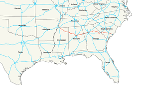
U.S. Route 78
| |
|---|---|
 | |
| Route information | |
| Length: | 715 mi[1] (1,151 km) |
| Existed: | 1926[1] – present |
| Major junctions | |
| West end: |
|
| |
| East end: | Line Street at Charleston, SC |
| Location | |
| States: | Tennessee, Mississippi, Alabama, Georgia, South Carolina |
| Highway system | |

U.S. Highway 78 is an east–west United States highway that runs for 715 miles (1,151 km) from Memphis, Tennessee, to Charleston, South Carolina. A segment of US 78 from near Memphis, Tennessee, to Birmingham, Alabama, is designated as Interstate 22.
The highway's western terminus is at U.S. Route 70 (Second Street) in Memphis, Tennessee. Its eastern terminus is on Line Street, in Charleston, South Carolina.
Route description
| mi | km | |
|---|---|---|
| TN | 14.7 | 23.6 |
| MS | 118.0 | 189.9 |
| AL | 194.0 | 312.2 |
| GA | 233.3 | 375.5 |
| SC | 141.0 | 226.9 |
| Total | 701.7 | 1,127.6 |
Tennessee

US-78 runs along Linden Avenue, Somerville Street, E. H. Crump Boulevard, and Lamar Avenue through Memphis, Tennessee. In Tennessee, US-78 is historically known as Pigeon Roost Road, and some aborted sections of the highway in Mississippi also claim that name as well as Lamar Avenue.[2]
Mississippi
US 78 is completely freeway from the Tennessee state line all the way to Graysville, Alabama. Although not currently a part of the U.S. Interstate system, it is now on its way to becoming Interstate 22, which will run from its intersection with the Memphis Outer Beltway in Byhalia to Birmingham. At the time the highway was reconstructed to freeway standards, conversion to an interstate was not considered likely. As a result, Tennessee has never upgraded its portion from the state line to Interstate 240. Mississippi's portion of U.S. 78 is defined in Mississippi Code Annotated § 65-3-3.
Mississippi officials announced on May 5, 2015 that the state officially began the process to designate its portion as I-22. The two requirements to be able to apply for this designation were to upgrade the route to interstate standards (as noted above) and to connect to an existing interstate within 25 years; this will be completed once I-269 is opened within the next couple years and the I-65 interchange is completed within the year.[3]
Alabama
US-78 is a major east–west state highway across the central part of Alabama. It is internally designated "State Route 4" (SR-4) by the Alabama Department of Transportation. Due to the construction of Interstate 22 along the US-78 corridor west of Birmingham, part of US-78 is temporarily State Route 5 only, since that part of the new I-22/US-78/SR-4 is not completed. US-78 roughly parallels Interstate 20 from Birmingham east to the Georgia state line.[4]
The only section of State Route 4 that is signed is along portions of the completed sections of future Interstate 22 (Corridor X), mainly west of Jasper. As of December, 2007, Corridor X is open from the Mississippi State line through the West Jefferson community, rejoining the old alignment near Graysville. As of January, 2009, the old routing of US-78 west of Graysville to Jasper is now signed only as AL 5. There is a possibility that, upon completion of I-22, US 78 may be decommissioned west of Birmingham. The stretch from I-20/59 at the Arkadelphia Road exit in Birmingham to Jasper would continue to be signed as AL 5. West of Jasper, the old US 78 is already signed as AL 118 to Guin, and then from Guin northward to I-22 at Hamilton is signed as US-43/US-278.
East of Birmingham, US 78 has been replaced as a major through-route by Interstate 20. The two routes roughly parallel each other, with junctions at Leeds and Pell City.
Georgia
US 78 enters Georgia in Haralson County, and then proceeds through Carroll County and Douglas County. In Douglasville, located in Douglas County, US 78 runs through the downtown, historical part of the city. It is the original thoroughfare for these Georgia counties.
There is another short freeway portion east of Atlanta, leading from just inside (west of) I-285 (the Perimeter) eastward to the suburb of Stone Mountain, Georgia. This portion is named the Stone Mountain Freeway, and has an excellent view of Stone Mountain while traveling eastbound.
The route then continues eastward through DeKalb, Gwinnett, Walton, and Oconee counties. In Oconee county US 78 leaves Moina Michael Highway at the SR 316 interchange, turning right and running concurrent with Ga. 316/US 29. (From this point, Moina Michael Highway is signed as US 78 Business, which follows the original route of US 78 through Athens, Ga.) At the terminal eastern interchange of SR 316 both US 78 and US 29 turn right and join with SR 10 Loop, a mostly interstate-grade bypass that rings Athens-Clarke County. US 78 exits the bypass and turns right at the Lexington Road interchange. From there US 78 passes through Oglethorpe, Wilkes, McDuffie and Columbia Counties into Augusta and then onto one of the twin bridges across the Savannah River into South Carolina.[5]
South Carolina
US 78 provides the most direct route between Augusta and Charleston, through the South Carolina Lowcountry. Crossing Savannah River into the state, it goes northeast into Aiken before going southeasterly through the cities and towns of Williston, Blackville, Denmark, Bamberg, Branchville, and St. George. East of Dorchester, it parallels Interstate 26 into downtown Charleston, where it ends.[6]
History
In western Alabama, the historical name of US 78 is Bankhead Highway. It is also known by this name in portions of Georgia, including Atlanta, and the Bankhead neighborhood takes its name from that stretch of road. Also, the old section of US 78 (now MS 178) that travels through downtown New Albany, Mississippi, is named Bankhead Street.
Future
There is a freeway portion of US 78 that begins from the Tennessee / Mississippi border near southeast Memphis and continues through Mississippi to Graysville, Alabama, and the freeway is under construction all the way to Birmingham, Alabama, where it will junction with Interstate 65 and U.S. Highway 31. Although there are major Interstate highways near this freeway's endpoints, it is a discrete segment of controlled-access freeway. This will change over the next few years as it is upgraded to become the new Interstate 22. It is uncertain whether US 78 will be decommissioned west of Birmingham or the old route recommissioned as US 78 upon completion of Interstate 22.
If the old route is recommissioned as US 78 after the opening of I-22, parts of I-22 and US 78 would be forced to overlap. A stretch from just west of Hamilton, Alabama to the first exit in Mississippi, as well as a stretch from MS 25 in Fulton, Mississippi to the next exit west of Fulton after crossing the Tennessee-Tombigbee waterway will overlap. The Hamilton area overlap would be due to the old US 78 routing no longer exists west of Hamilton having been upgraded to I-22 from Weston westward into Mississippi. The second overlap would be necessary because the old US 78 no longer exists west of downtown Fulton, Mississippi due to the Tennessee-Tombigbee waterway and no bridge in place to carry US 78 traffic on the former route.
In Mississippi, the old routing is numbered as Mississippi State Route 178. In Alabama, the old routing is numbered as Alabama State Route 118 (west of Jasper) and Alabama State Route 5 (east of Jasper) to Graysville where US 78 is co-signed with Alabama 5 into Birmingham.
Major intersections
- Tennessee
-


 US 64 / US 70 / US 79 in Memphis
 -
 I‑240 in Memphis
 -
 US 51 in Memphis
 - I‑240 in Memphis
- Mississippi
-

.svg.png) I‑22 / Future I‑269 west-northwest of Byhalia. I-22/US 78 travels concurrently to the Adamsville–Graysville, Alabama city line. Begin I-22 Concurrency.
I‑22 / Future I‑269 west-northwest of Byhalia. I-22/US 78 travels concurrently to the Adamsville–Graysville, Alabama city line. Begin I-22 Concurrency. -
 US 45 in Tupelo
 - Alabama
-

 US 43 / US 278 in Hamilton
 - I‑22 near Adamsville. End I-22 Concurrency.
-
.svg.png) Future I‑422 near Adamsville
Future I‑422 near Adamsville -

 I‑20 / I‑59 in Birmingham
 -
 US 11 in Birmingham. The highways travel concurrently through Birmingham.
 -
 I‑65 in Birmingham
 -

 US 31 / US 280 in Birmingham
 - I‑20 in Leeds
- I‑20 northwest of Cooks Springs. The highways travel concurrently to Pell City.
-
 US 231 in Pell City
 - I‑20 in Riverside
-
 US 431 in Oxford.
 - Georgia
-
 US 27 in Bremen
 - US 278 in Lithia Springs. The highways travel concurrently to Druid Hills.
-
 I‑285 in Atlanta
 -

 US 19 / US 41 in Atlanta. The highways travel concurrently through Atlanta.
 -
 US 19 / US 29 / US 41 in Atlanta. US 29/US 78 travels concurrently to the Scottdale–North Decatur city line.
 -
 US 23 in Atlanta. The highways travel concurrently to Decatur.
 - I‑285 on the Scottdale–Clarkston city line
- US 29 southeast of Bogart. The highways travel concurrently to Athens.
-

 US 129 / US 441 in Athens. The highways travel concurrently through Athens.
 -
 US 378 in Washington
 - US 278 southeast of Thomson. The highways travel concurrently to Clearwater, South Carolina.
-
 US 221 in Harlem
 -
 I‑520 in Augusta
 -
 US 1 in Augusta. The highways travel concurrently to Aiken, South Carolina.
 -
 US 25 in Augusta. The highways travel concurrently to North Augusta, South Carolina.
 - South Carolina
- I‑520 in North Augusta
-
 US 321 in Denmark
 -

 US 301 / US 601 in Bamberg
 -
 US 21 in Branchville. The highways travel concurrently through Branchville.
 -
 I‑95 in St. George
 -
 US 15 in St. George
 -
 US 178 east of Dorchester
 -
 I‑26 in North Charleston
 -
 US 52 in North Charleston. The highways travel concurrently through North Charleston.
 - I‑26 in North Charleston
-
 I‑526 in North Charleston
 - King Street/Line Street in Charleston
Bannered routes
US 78N
| |
|---|---|
| Location: | Heflin, Alabama–Villa Rica, Georgia |
| Existed: | 1927[7][8]–November 1934[9][10] |
U.S. Route 78N (US 78N) was a northern divided U.S. highway that comprised the current mainline of US 78 from Heflin, Alabama, to Villa Rica, Georgia.
The road that would eventually become US 78N was established in 1920, as SR 8 from the Alabama state line to Villa Rica.[11] By the end of the third quarter of 1926, US 78 was established, being designated along a local roadway from Heflin to the state line, and SR 8 from the state line to Villa Rica.[7][12] The next year, US 78 split into two divided routes, with US 78N being designated from Heflin to Villa Rica, on the northern segment of SR 8 (thereby replacing the mainline highway).[13] In 1928, Alabama State Route 4 (SR-4) was designated along US-78N.[13][14] By May 1933, US 78N/SR 8 were paved from Bremen to Villa Rica.[15][16] Later that month, US 78N/SR 8 were paved from east of the Alabama state line to Bremen.[16][17] The next month, US 78N/SR 8 were paved west to the Alabama state line.[17][18] By November 1934, US 78N was redesignated as part of mainline US 78.[9][10]
US 78S
| |
|---|---|
| Location: | Heflin, Alabama–Villa Rica, Georgia |
| Existed: | 1927[13]–November 1934[9][10] |
U.S. Route 78S (US 78S) was a southern divided U.S. highway that comprised the current length of Alabama State Route 46 from Heflin, Alabama, to the Georgia state line, SR 166 from the state line to Carrollton, and SR 61 from Carrollton to Villa Rica.
The road that would eventually become US 78 was established in 1920 as part of SR 34 from Carrollton to Villa Rica.[11] By the end of the third quarter of 1921, SR 16 was designated from the Alabama state line, west of Bowdon to Carrollton.[11][12] By late 1926, SR 16 and SR 34 were redesignated as a southern branch of SR 8.[7][12] In 1927, US 78 split into two divided routes, with US 78S being designated from Heflin to Villa Rica, via Bowdon and Carrollton, on the southern branch of SR 8.[13] In 1928, Alabama State Route 4 (SR-4) was designated along US-78N, while SR-46 was designated along US-78S.[13][14] By 1932, US 78S/SR 8 were paved from Carrollton to just southwest of Villa Rica.[8][19] By the end of 1934, US 78S/SR 8 were paved from the Alabama state line to a point near Bowdon.[20][21] By November 1934, US 78S was redesignated as US 78 Alternate.[9][10] By the beginning of 1948, the southern branch of SR 8 was redesignated as SR 8 Alternate.[22][23] By the middle of 1954, SR 8 Alternate was redesignated as SR 166 from the Alabama state line to northeast of Carrollton) and SR 61 from there to Villa Rica.[24][25]
Heflin–Villa Rica alternate route
| |
|---|---|
| Location: | Heflin, Alabama–Villa Rica, Georgia |
| Existed: | 1934[9][10]–1954[24][25] |
U.S. Route 78 Alternate (US 78 Alt.) was an alternate route of US 78 in northeast Alabama and northwest Georgia. It comprised the current length of Alabama State Route 46 (SR 46) from Heflin, Alabama, to the Georgia state line, SR 166 from the state line to Carrollton, and SR 61 from Carrollton to Villa Rica.
The road that would eventually become US 78 Alternate was established in 1920 as part of SR 34 from Carrollton to Villa Rica.[11] By the end of the third quarter of 1921, SR 16 was designated from the Alabama state line, west of Bowdon to Carrollton.[11][12] By late 1926, SR 16 and SR 34 were redesignated as a southern branch of SR 8.[7][12] In 1927, US 78 split into two divided routes, with US 78S being designated from Heflin to Villa Rica, via Bowdon and Carrollton, on the southern branch of SR 8.[13] In 1928, SR 4 was designated along US-78N, while SR 46 was designated along US-78S.[13][14] By 1932, US 78S/SR 8 were paved from Carrollton to just southwest of Villa Rica.[8][19] By the end of 1934, US 78S/SR 8 were paved from the Alabama state line to a point near Bowdon.[20][21] By November 1934, US 78S was redesignated as US 78 Alt.[9][10] By the beginning of 1948, the southern branch of SR 8 was redesignated as SR 8 Alternate.[22][23] By the end of 1953, US 78 Alt. was decommissioned.[24][26] By the middle of 1954, SR 8 Alternate was redesignated as SR 166 from the Alabama state line to northeast of Carrollton) and SR 61 from there to Villa Rica.[24][25]
See also
Related U.S. Routes
References
- 1 2 US Highways from US 1 to US 830 Robert V. Droz
- ↑ Google (April 11, 2014). "Route of US-78 in Tennessee" (Map). Google Maps. Google. Retrieved April 11, 2014.
- ↑ "Interstate 22 designation moving nearer". Northeast Mississippi Daily Journal.
- ↑ Google (April 11, 2014). "Route of US 78 in Alabama" (Map). Google Maps. Google. Retrieved April 11, 2014.
- ↑ Google (April 11, 2014). "Route of US 78 in Georgia" (Map). Google Maps. Google. Retrieved April 11, 2014.
- ↑ Google (April 11, 2014). "Route of US 78 in South Carolina" (Map). Google Maps. Google. Retrieved April 11, 2014.
- 1 2 3 4 Georgia State Highway Map (PDF) (Map). Cartography by GSHD. Georgia Department of Transportation. October 1, 1926. Retrieved April 18, 2014.
- 1 2 3 Georgia State Highway Map (PDF) (Map). Cartography by GSHD. Georgia Department of Transportation. October 1, 1929. Retrieved April 18, 2014.
- 1 2 3 4 5 6 State Road Map of Alabama (XSL) (Map). General Drafting. 1933. Retrieved April 18, 2014.
- 1 2 3 4 5 6 State Road Map of Alabama (XSL) (Map). General Drafting. November 1, 1934. Retrieved April 18, 2014.
- 1 2 3 4 5 Georgia State Highway Map (PDF) (Map). Cartography by GSHD. Georgia Department of Transportation. January 1, 1920. Retrieved April 18, 2014.
- 1 2 3 4 5 Georgia State Highway Map (PDF) (Map). Cartography by GSHD. Georgia Department of Transportation. September 23, 1921. Retrieved April 18, 2014.
- 1 2 3 4 5 6 7 Alabama System of State Roads (XSL) (Map). Alabama Department of Transportation. January 1, 1927. Retrieved April 18, 2014.
- 1 2 3 State Road Map of Alabama (XSL) (Map). Alabama Department of Transportation. Fall 1928. Retrieved April 18, 2014.
- ↑ Georgia State Highway Map (PDF) (Map). Cartography by GSHD. Georgia Department of Transportation. November 1, 1932. Retrieved April 18, 2014.
- 1 2 Georgia State Highway Map (PDF) (Map). Cartography by GSHD. Georgia Department of Transportation. May 1, 1933. Retrieved April 18, 2014.
- 1 2 Georgia State Highway Map (PDF) (Map). Cartography by GSHD. Georgia Department of Transportation. June 1, 1933. Retrieved April 18, 2014.
- ↑ Georgia State Highway Map (PDF) (Map). Cartography by GSHD. Georgia Department of Transportation. July 1, 1933. Retrieved April 18, 2014.
- 1 2 Georgia State Highway Map (PDF) (Map). Cartography by GSHD. Georgia Department of Transportation. January 1, 1932. Retrieved April 18, 2014.
- 1 2 Georgia State Highway Map (PDF) (Map). Cartography by GSHD. Georgia Department of Transportation. April 1, 1934. Retrieved April 18, 2014.
- 1 2 Georgia State Highway Map (PDF) (Map). Cartography by GSHD. Georgia Department of Transportation. October 1, 1934. Retrieved April 18, 2014.
- 1 2 Georgia State Highway Map (PDF) (Map). Cartography by GSHD. Georgia Department of Transportation. November 7, 1946. Retrieved April 18, 2014.
- 1 2 Georgia State Highway Map (PDF) (Map). Cartography by GSHD. Georgia Department of Transportation. February 28, 1948. Retrieved April 18, 2014.
- 1 2 3 4 Georgia State Highway Map (PDF) (Map). Cartography by GSHD. Georgia Department of Transportation. September 1, 1953. Retrieved April 19, 2014.
- 1 2 3 Georgia State Highway Map (PDF) (Map). Cartography by GSHD. Georgia Department of Transportation. June 1, 1954. Retrieved April 18, 2014.
- ↑ Georgia State Highway Map (PDF) (Map). Cartography by GSHD. Georgia Department of Transportation. January 1, 1952. Retrieved April 19, 2014.
External links
| Wikimedia Commons has media related to U.S. Route 78. |
- Evermore Community Improvement District
- High Priority Corridors @ aaroads.com
- Highway 78 CID
- Highway 78 on OpenStreetMap.org
| Browse numbered routes | ||||
|---|---|---|---|---|
| ← | TN | SR 78 | ||
| ← | MS | US 80 | ||
| ← | AL | SR 79 | ||
Routes in italics are no longer a part of the system. Highlighted routes are considered main routes of the system. |