Jefferson County, Arkansas
| Jefferson County, Arkansas | |
|---|---|
| County | |
| County of Jefferson | |
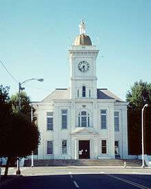 Jefferson County Courthouse, Pine Bluff. | |
 Location in the U.S. state of Arkansas | |
 Arkansas's location in the U.S. | |
| Founded | November 2, 1829 |
| Named for | Thomas Jefferson |
| Government • County Judge |
Dutch King (D) |
| Seat | Pine Bluff |
| Largest city | Pine Bluff |
| Area | |
| • Total | 914 sq mi (2,367 km2) |
| • Land | 871 sq mi (2,256 km2) |
| • Water | 43 sq mi (111 km2), 4.7% |
| Population (est.) | |
| • (2015) | 71,565 |
| • Density | 89/sq mi (34/km²) |
| ZIP code(s) | 71601, 71602, 71603, 71644, 71659, 72004, 72046, 72073, 72079, 72132, 72150, 72152, 72160, 72168, 72175 |
| Area code(s) | 501, 870 |
| Congressional districts | 1st, 4th |
| Time zone | Central: UTC-6/-5 |
| Website |
jeffersoncounty |
Jefferson County, Arkansas is a county located in the U.S. state of Arkansas in the area known as the Arkansas Delta, that extends west of the Mississippi River. As of the 2010 census, the population was 77,435.[1] Its county seat and largest city is Pine Bluff.[2] Jefferson County is Arkansas's 21st county, formed on November 2, 1829, from portions of Arkansas and Pulaski counties, and named for Thomas Jefferson,[3] third President of the United States. Jefferson County is included in the Pine Bluff, Arkansas Metropolitan Statistical Area. The county is bisected by the Arkansas River, which was critical to its development and long the chief transportation byway.
History
The area that would later become Jefferson County was occupied by the Quapaw when French explorers established the Arkansas Post in the 17th century; the foreigners claimed this area as Louisiana, part of New France.[4]
In March 1819, Robert Crittenden was appointed secretary of Arkansas Territory. That same year, Joseph Bonne, traveling upstream on the Arkansas River from Arkansas Post, built a cabin on a “high bluff covered with pine trees” on the river’s south bank.[4] Several years later, James Scull, also from Arkansas Post, established a tavern and small inn on the river's north bank, across from what would become the site of Pine Bluff.[4]
Five years later, Crittenden convinced the remaining Quapaw to sign the November 15, 1824 treaty relinquishing what remained of their tribal lands.[4] Steamboat travel led to expanding settlement, "bringing to the area such men as French-born Napoleonic soldier Antoine Barraque (Pine Bluff’s principal east-west street was named for him) and brothers James T. and John Pullen (main thoroughfares were named for them)."[4]
On November 2, 1829, Territorial Governor John Pope—Crittenden's successor—approved the establishment of Jefferson County. Bonne’s cabin was used as the county seat; by August 1832, "Pine Bluff Town" became the county seat."[4] The land in the county was developed as large cotton plantations, with fronts on the river for transportation. The plantations were dependent on the labor of enslaved African Americans, who comprised a majority of the population in the county well before the American Civil War.
After the war, planters in Jefferson County gradually resumed cotton cultivation and processing. The economy was driven by cotton and the Delta area was highly productive. In 1886, Jefferson County produced 55,120 bales of cotton, the most in Arkansas, and the second-most throughout the South.[5] Transportation companies serving the county at the time included the Cotton Belt Route, the St. Louis – San Francisco Railway, Missouri Pacific, the Arkansas River Packet Company, the Wiley Jones Street Car Lines, and the Citizens Street Railway Company.[6] The street car lines operated primarily in Pine Bluff.
Geography
According to the U.S. Census Bureau, the county has a total area of 914 square miles (2,370 km2), of which 871 square miles (2,260 km2) is land and 43 square miles (110 km2) (4.7%) is water.[7] About 75% of the county including the largest city, Pine Bluff, is located in the Arkansas Delta with the remaining portion in the Arkansas Timberlands. Consequently, it is largely low-lying flatland to the east used primarily for agriculture and expanses of trees used for timber to the west.
Major highways
.svg.png) Interstate 530
Interstate 530 U.S. Highway 65
 U.S. Highway 79
 U.S. Highway 270
 U.S. Highway 425
 Highway 15
 Highway 31
 Highway 46
 Highway 58
 Highway 81
 Highway 88
Adjacent counties
- Lonoke County (northeast)
- Arkansas County (east)
- Lincoln County (southeast)
- Cleveland County (southwest)
- Grant County (west)
- Pulaski County (northwest)
Demographics
| Historical population | |||
|---|---|---|---|
| Census | Pop. | %± | |
| 1830 | 772 | — | |
| 1840 | 2,566 | 232.4% | |
| 1850 | 5,834 | 127.4% | |
| 1860 | 14,971 | 156.6% | |
| 1870 | 15,733 | 5.1% | |
| 1880 | 22,386 | 42.3% | |
| 1890 | 40,881 | 82.6% | |
| 1900 | 40,972 | 0.2% | |
| 1910 | 52,734 | 28.7% | |
| 1920 | 60,330 | 14.4% | |
| 1930 | 64,154 | 6.3% | |
| 1940 | 65,101 | 1.5% | |
| 1950 | 76,075 | 16.9% | |
| 1960 | 81,373 | 7.0% | |
| 1970 | 85,329 | 4.9% | |
| 1980 | 90,718 | 6.3% | |
| 1990 | 85,487 | −5.8% | |
| 2000 | 84,278 | −1.4% | |
| 2010 | 77,435 | −8.1% | |
| Est. 2015 | 71,565 | [8] | −7.6% |
| U.S. Decennial Census[9] 1790–1960[10] 1900–1990[11] 1990–2000[12] 2010–2015[1] | |||
As of the 2010 census, there were 77,435 people residing in the county. 55.1% were Black or African American, 42.0% White, 0.8% Asian, 0.3% Native American, 0.7% of some other race and 1.2% of two or more races. 1.6% were Hispanic or Latino (of any race).[14]
As of the census of 2000,[15] there were 84,278 people, 30,555 households, and 21,510 families residing in the county. The population density was 95 people per square mile (37/km²). There were 34,350 housing units at an average density of 39 per square mile (15/km²). The racial makeup of the county was 49.58% Black or African American, 48.46% White, 0.24% Native American, 0.66% Asian, 0.04% Pacific Islander, 0.26% from other races, and 0.76% from two or more races. 0.96% of the population were Hispanic or Latino of any race. By comparison, the county had 15,714 residents in 1870, 20% of whom were White.[16]
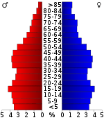
In the county there were 30,555 households out of which 33.10% had children under the age of 18 living with them, 47.40% were married couples living together, 18.80% had a female householder with no husband present, and 29.60% were non-families. 26.20% of all households were made up of individuals and 10.60% had someone living alone who was 65 years of age or older. The average household size was 2.59 and the average family size was 3.13. The population was spread out with 26.30% under the age of 18, 10.80% from 18 to 24, 27.80% from 25 to 44, 22.10% from 45 to 64, and 12.90% who were 65 years of age or older. The median age was 35 years. For every 100 females there were 95.90 males. For every 100 females age 18 and over, there were 93.40 males.
Jefferson County experienced a decline in population between 2000 and 2010 of 8.1%.[17] The county has continued to decline in population since 2010, showing a 3.5% decrease in population to 74,723 between the 2010 census and the 2012 (-3.5%) census estimates.[18]
The median income for a household in the county was $31,327, and the median income for a family was $38,252. Males had a median income of $31,848 versus $21,867 for females. The per capita income for the county was $15,417. About 16.00% of families and 20.50% of the population were below the poverty line, including 29.60% of those under age 18 and 17.80% of those age 65 or over.
Government and infrastructure
The state has built a number of correctional facilities in and near Pine Bluff, and moved the headquarters of the Arkansas Department of Correction (ADC) to here in 1979.[19][20][21] The administrative Annex East is on Harding Avenue in Pine Bluff, south of city hall.[22] The Diagnostic Unit,[23] the Pine Bluff Unit, and the Randall L. Williams Correctional Facility are in the "Pine Bluff Complex" in Pine Bluff.[24][25] The headquarters of the Arkansas Correctional School system are within the Pine Bluff Complex.[25][26]
The Arkansas Department of Community Correction Southeast Arkansas Community Corrections Center is in Pine Bluff.[27] The Maximum Security Unit is 25 miles (40 km) north of central Pine Bluff and off Arkansas Highway 15 in unincorporated Jefferson County.[28] The Tucker Unit is also located north of Pine Bluff.[29] Historically the Arkansas Boys' Industrial School and the Arkansas Negro Boys' Industrial School were in the county.[30]
Communities
Cities
- Altheimer
- Humphrey
- Pine Bluff (county seat)
- Redfield
- White Hall
Towns
Unincorporated communities
Historical towns
Townships
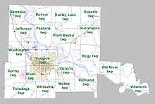
Townships in Arkansas are the divisions of a county. Each township includes unincorporated areas; some may have incorporated cities or towns within part of their boundaries. Arkansas townships have limited purposes in modern times. However, the United States Census does list Arkansas population based on townships (sometimes referred to as "county subdivisions" or "minor civil divisions"). Townships are also of value for historical purposes in terms of genealogical research. Each town or city is within one or more townships in an Arkansas county based on census maps and publications. The townships of Jefferson County are listed below; listed in parentheses are the cities, towns, and/or census-designated places that are fully or partially inside the township. [37][38]
- Barraque (Redfield)
- Bogy
- Bolivar
- Dudley Lake
- Dunnington (Wabbaseka)
- Jefferson
- Melton
- Niven
- Old River
- Pastoria
- Plum Bayou (Altheimer, Sherrill)
- Richland
- Roberts (Humphrey)
- Spring
- Talladega
- Vaugine (Pine Bluff)
- Victoria
- Villemont
- Washington (White Hall)
- Whiteville
Notable people
- Powell Clayton (1833-1914), American politician
- Moses Clegg (1876-1918), American bacteriologist
See also
- List of counties in Arkansas
- List of lakes in Jefferson County, Arkansas
- List of places named for Thomas Jefferson
- National Register of Historic Places listings in Jefferson County, Arkansas
References
- 1 2 "State & County QuickFacts". United States Census Bureau. Retrieved May 22, 2014.
- ↑ "Find a County". National Association of Counties. Retrieved June 7, 2011.
- ↑ Gannett, Henry (1905). The Origin of Certain Place Names in the United States (Report) (2nd ed.). Washington: Government Printing Office. p. 168 – via United States Geological Survey.
- 1 2 3 4 5 6 7 Bearden, Russell E. (February 5, 2016). "Jefferson County". The Encyclopedia of Arkansas History & Culture. Central Arkansas Library System. Retrieved April 30, 2016.
- ↑ Jefferson County Immigration Bureau (August 1888). Jefferson County, Arkansas: Full Description. Chicago: C.S. Burch Publishing Co. p. 4. Retrieved August 21, 2011.
- ↑ Jefferson County Immigration Bureau (August 1888). Jefferson County, Arkansas: Full Description. Chicago: C.S. Burch Publishing Co. pp. 15–16. Retrieved August 21, 2011.
- ↑ "2010 Census Gazetteer Files". United States Census Bureau. August 22, 2012. Retrieved August 26, 2015.
- ↑ "County Totals Dataset: Population, Population Change and Estimated Components of Population Change: April 1, 2010 to July 1, 2015". Retrieved July 2, 2016.
- ↑ "U.S. Decennial Census". United States Census Bureau. Retrieved August 26, 2015.
- ↑ "Historical Census Browser". University of Virginia Library. Retrieved August 26, 2015.
- ↑ Forstall, Richard L., ed. (March 27, 1995). "Population of Counties by Decennial Census: 1900 to 1990". United States Census Bureau. Retrieved August 26, 2015.
- ↑ "Census 2000 PHC-T-4. Ranking Tables for Counties: 1990 and 2000" (PDF). United States Census Bureau. April 2, 2001. Retrieved August 26, 2015.
- ↑ Based on 2000 census data
- ↑ 2010 census report for Jefferson County, Arkansas
- ↑ "American FactFinder". United States Census Bureau. Retrieved May 14, 2011.
- ↑ Jefferson County Immigration Bureau (August 1888). Jefferson County, Arkansas: Full Description. Chicago: C.S. Burch Publishing Co. p. 3. Retrieved August 21, 2011.
- ↑ Jefferson County at USA.com
- ↑ "Quick Facts: Jefferson County, AR", US Census Bureau
- ↑ "2006 Facts Brochure." Arkansas Department of Correction. July 1, 2005-June 30, 2006. 25 (25/38). Retrieved on August 15, 2010.
- ↑ "Pine Bluff city, Arkansas." U.S. Census Bureau. Retrieved on September 7, 2010.
- ↑ "Central Office." Arkansas Department of Correction. Retrieved on June 28, 2010.
- ↑ "Facilities." Arkansas Department of Correction. Retrieved on June 28, 2010.
- ↑ "Diagnostic Unit." Arkansas Department of Correction. Retrieved on June 28, 2010.
- ↑ "Pine Bluff Unit/Randall L. Williams Correctional Facility." Arkansas Department of Correction. Retrieved on June 28, 2010.
- 1 2 "School Sites." Arkansas Correctional School. Retrieved on July 18, 2010.
- ↑ "Contact Us." Arkansas Correctional School. Retrieved on July 18, 2010.
- ↑ "Locations." Arkansas Department of Community Corrections. Retrieved on March 5, 2011. "7301 West 13th Street, Pine Bluff, Arkansas 71602"
- ↑ "Maximum Security Unit." Arkansas Department of Correction. Retrieved on June 28, 2010.
- ↑ "Pine Bluff Unit/Randall L. Williams Correctional Facility/Tucker Unit." Arkansas Department of Correction. Retrieved on June 28, 2010.
- ↑ Arkansas State Highway Commission; United States Department of Agriculture (1936). General Highway and Transportation Map, Jefferson County, Arkansas (Map). Archived from the original on December 31, 2003. Retrieved April 30, 2016.
- ↑ Worthan, Jacob (March 29, 2016). "Sulphur Springs (Jefferson County)". The Encyclopedia of Arkansas History & Culture. Central Arkansas Library System. Retrieved April 30, 2016.
- ↑ Easley, Tina. "Forgotten Places in Arkansas". Genealogy Trails. Genealogy Trails History Group. Retrieved April 30, 2016.
- ↑ Forte, Jim. "Post Offices--Past and Present". Genealogy Trails. Genealogy Trails History Group. Retrieved April 30, 2016.
- ↑ "Diantha (historical) in Jefferson County AR". AR HomeTownLocator. HTL, Inc. Retrieved April 30, 2016.
- ↑ Easley, Tina. "Forgotten Places in Arkansas (Part Two)". Genealogy Trails. Genealogy Trails History Group. Retrieved April 30, 2016.
- ↑ Rand, McNally & Co.'s New Business Atlas Map of Arkansas (Map). 1:900,000. Rand, McNally & Co. 1898. Retrieved April 30, 2016.
- ↑ 2011 Boundary and Annexation Survey (BAS): Jefferson County, AR (PDF) (Map). U. S. Census Bureau. Retrieved 2011-08-13.
- ↑ "Arkansas: 2010 Census Block Maps - County Subdivision". United States Census Bureau. Retrieved May 29, 2014.
Further reading
- Biographical and Historical Memoirs of Pulaski, Jefferson, Lonoke, Faulkner, Grant, Saline, Perry, Garland and Hot Spring Counties, Arkansas. Chicago, Nashville and St. Louis: Goodspeed Publishing Co. 1889.
- Leslie, James W. (1981). Pine Bluff and Jefferson County: A Pictorial History. Norfolk, Va.: Donning Co. ISBN 978-0898651485.
- Pine Bluff and Jefferson County, Arkansas: Descriptive Pamphlet. Jefferson County Exposition and Bureau of Agriculture, Manufactures and Immigration. Feb 22, 1895 – via Graphic Printing Company, Pine Bluff, Ark.
- Pine Bluff and Jefferson County, Arkansas: Full Description (World's Fair ed.). Jefferson County Bureau of Agriculture, Manufactures and Immigration. May 1893.
- Wilson, W. H. D. (1872). Wilson's Map of Jefferson County, Arkansas (Map). Pine Bluff, Arkansas: W. H .D. Wilson, Real Estate Broker & General Land Agent.
External links
| Wikimedia Commons has media related to Jefferson County, Arkansas. |
- Official
- County Assessor Official site of the Jefferson County Assessor's Office
- County Clerk Official site of the Jefferson County Clerk's Office
- Sheriff’s Office Official site of the Jefferson County Sheriff's Office
- Tax Collector Official site of the Jefferson County Tax Collector
- General information
- Jefferson County, Arkansas (ARGenWeb)
- Jefferson Regional Medical Center
- Pine Bluff and Jefferson County Historical Museum
- Pine Bluff and Jefferson County Library System
 |
Pulaski County | |
Lonoke County | |
| Grant County | |
Arkansas County | ||
| ||||
| | ||||
| Cleveland County | |
Lincoln County |
Coordinates: 34°17′15″N 91°56′32″W / 34.28750°N 91.94222°W