U.S. Route 275
| |
|---|---|
 | |
| Route information | |
| Auxiliary route of US 75 | |
| Length: |
265.82 mi[lower-alpha 1] (427.80 km)
|
| Major junctions | |
| South end: |
|
| |
| North end: |
|
| Location | |
| States: | |
| Highway system | |

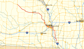
U.S. Route 275 (US 275) is a north–south United States highway. It is a branch of US 75, originally terminating at that route in Council Bluffs, Iowa. The highway's northern terminus is in O'Neill, Nebraska, at an intersection with U.S. Highway 20 and U.S. Highway 281. Its southern terminus is near Rock Port, Missouri, at an intersection with U.S. Highway 136.
Its former route which has been replaced by Interstate 29 was celebrated in the 1971 Brewer & Shipley Tarkio Road album which featured the song One Toke Over the Line.[1]
Route description
U.S. 275 is signed north–south in Missouri and Iowa, while in Nebraska, it is signed east–west.
Missouri
U.S. Route 275 begins at an intersection with U.S. Route 136 1 mile (1.6 km) west of Rock Port. It travels to the north and to the northwest through Atchison County for 16 miles (26 km).[2]
Iowa
U.S. Route 275 crosses into Iowa 1 1⁄2 miles (2.4 km) south of Hamburg. It enters Hamburg and intersects Iowa Highway 333 (Iowa 333), which connects to Interstate 29 (I-29) 1 1⁄2 miles (2.4 km) to the west. North of Hamburg, it intersects Iowa 2, and the two routes share 5 miles (8.0 km) of road. US 275 and Iowa 2 then bypass Sidney on its east side, and east of Sidney, US 275 and Iowa 2 separate. From east of Sidney, US 275 continues north for 20 miles (32 km) through Tabor until it intersects U.S. Route 34 east of Glenwood. US 275 and US 34 then overlap for 8 miles (13 km), mostly bypassing Glenwood. West of Glenwood, US 34 and US 275 split at an interchange with I-29; US 34 follows southbound I-29, while US 275 follows northbound I-29. For 13 miles (21 km), US 275 overlaps I-29, ending at an interchange with Iowa 92 in southern Council Bluffs. Turning west, US 275 / Iowa 92 travel together for 5 miles (8.0 km) in Iowa and cross the new South Omaha Veterans Memorial Bridge over the Missouri River.[3]
Nebraska
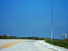
US 275 enters Nebraska in Omaha in the South Omaha neighborhood paired with Nebraska Highway 92. It goes through Omaha as a four-lane highway until meeting Nebraska Highway 31. The street designations for US 275 in Omaha are, from east to west, Missouri Avenue, L Street, Industrial Road and West Center Road. It crosses the Elkhorn River, which it will follow for most of the rest of the route, then separates from NE 92. It goes northwest and becomes freeway until Fremont. It meets U.S. Route 30 and they are paired together around Fremont until meeting U.S. Route 77. US 275 turns north with US 77, meets Nebraska Highway 91 and separates from US 77 near Winslow.
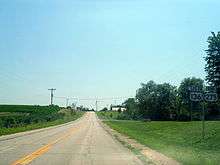
It turns northwest with NE 91 and they separate near Scribner, Nebraska. US 275 goes north through West Point, turns northwest through Wisner, and then turns west. At Norfolk it meets U.S. Route 81. It continues west-northwest, meets U.S. Route 20 near Inman and the two routes overlap until US 275 ends at an intersection with U.S. Route 281 in downtown O'Neill.
History
At its creation in 1932, US 275 ran from Council Bluffs to Saint Joseph, Missouri. In 1939 the route was extended northwest into Nebraska. In 1963 US 275 was truncated to its current end in northwestern Missouri.
Prior to 1963, US 275 extended south to St. Joseph. The route followed current U.S. Route 136 east from Rock Port to its intersection with U.S. Route 59 near Tarkio, then south with US 59 to St. Joseph.
Before November 2001, US 275 ran alongside the Union Pacific tracks between Waterloo and Fremont, Nebraska. This routing was replaced by a new freeway segment built as part of a project to connect Fremont via freeway to Omaha. This segment is officially called Reichmuth Road in Douglas County and Bell Street in Fremont.
Prior to July 1, 2003, US 275 followed a winding two-lane road between Council Bluffs and Glenwood, Iowa. The segment moved to a concurrency with U.S. Route 34 and Interstate 29 that day as part of a mass decommissioning of highways in Iowa. This road is now Mills County and Pottawattamie County Road L35.
Major intersections
Mileposts reset at state line crossings. In Nebraska, US 275 is considered an east–west highway, its mileposts run from west to east
| State | County | Location | mi[3][4][5] | km | Exit | Destinations | Notes |
|---|---|---|---|---|---|---|---|
| Missouri | Atchison | Rock Port | 0.000 | 0.000 | |||
| 15.576 0.000 | 25.067 0.000 | Missouri–Iowa state line | |||||
| Iowa | Fremont | Hamburg | 2.129 | 3.426 | Eastern terminus of Iowa 333 | ||
| Riverton | 7.950 | 12.794 | South end of Iowa 2 overlap | ||||
| Sidney | 12.671 | 20.392 | North end of Iowa 2 overlap | ||||
| Mills | Glenwood | 33.544 | 53.984 | South end of US 34 overlap | |||
| 41.824 | 67.309 | North end of US 34 overlap; south end of I-29 overlap; I-29 exit 35 | |||||
| Saint Marys–Oak township line | 49.152 | 79.102 | 42 | Former Iowa 370; exit number follows I-29 | |||
| Pottawattamie | Council Bluffs | 54.212 | 87.246 | North end of I-29 overlap; south end of Iowa 92 overlap; I-29 exit 47 | |||
| Missouri River | 59.391 190.85 | 95.581 307.14 | South Omaha Veterans Memorial Bridge; Iowa–Nebraska state line | ||||
| Nebraska | Douglas | Omaha | 189.53 | 305.02 | |||
| 185.69 | 298.84 | 72nd Street | Interchange | ||||
| 184.69 | 297.23 | Northern terminus of N-85 | |||||
| 181.93 | 292.79 | Cloverleaf interchange with I-80 C/D lanes | |||||
| 180.70 | 290.81 | Northern terminus of N-50 | |||||
| 174.18 | 280.32 | ||||||
| | 171.14 | 275.42 | West end of N-92 overlap | ||||
| | 168.53 | 271.22 | East end of freeway section; western terminus of L-28B | ||||
| Waterloo | 168.05 | 270.45 | — | Blondo Street | |||
| 166.55 | 268.04 | — | Eastbound exit and westbound entrance; east end of N-64 overlap | ||||
| Valley | 164.99 | 265.53 | — | Meigs Street | |||
| 163.02 | 262.36 | — | West end of N-64 overlap | ||||
| Mercer | 158.48 | 255.05 | — | ||||
| Dodge | Fremont | 154.72 | 249.00 | — | Morningside Road | ||
| 153.69 | 247.34 | — | Military Avenue | ||||
| 152.14 | 244.85 | — | East end of US 30 overlap | ||||
| Luther Road | West end of freeway section | ||||||
| 148.51 | 239.00 | Interchange; east end of US 77 overlap; west end of US 30 overlap | |||||
| Nickerson | 144.70 | 232.87 | East end of N-91 overlap | ||||
| Winslow | 140.85 | 226.68 | Interchange; west end of US 77 overlap; westbound exit and eastbound entrance only | ||||
| Pebble Township | 126.82 | 204.10 | West end of N-91 overlap | ||||
| Cuming | West Point | 118.15 | 190.14 | East end of N-32 overlap | |||
| 117.49 | 189.08 | West end of N-32 overlap | |||||
| 116.04 | 186.75 | Southern terminus of N-9 | |||||
| Beemer | 109.27 | 175.85 | Southern terminus of L-20A | ||||
| Wisner | 100.80 | 162.22 | Western terminus of N-51 | ||||
| Stanton | Pilger | 96.08 | 154.63 | East end of N-15 overlap | |||
| 94.08 | 151.41 | West end of N-15 overlap | |||||
| Spurville | 86.06 | 138.50 | Northern terminus of N-57 | ||||
| Madison | Norfolk | 77.47 | 124.68 | Western terminus of N-24; western terminus of N-35 | |||
| 75.12 | 120.89 | ||||||
| Battle Creek | 65.71 | 105.75 | Northern terminus of N-121 | ||||
| Antelope | Tilden | 53.39 | 85.92 | Northern terminus of N-45 | |||
| Neligh | 39.63 | 63.78 | |||||
| Holt | Ewing | 21.29 | 34.26 | Southern terminus of L-45B | |||
| Golden Township | 13.03 | 20.97 | East end of US 20 overlap | ||||
| O'Neill | 0.00 | 0.00 | West end of US 20 overlap; highway continues as US 20 west / US 281 north | ||||
1.000 mi = 1.609 km; 1.000 km = 0.621 mi
| |||||||
See also
Related routes
Bannered routes
- U.S. Route 275 Business - Fremont, Nebraska
Footnotes
- ↑ Total mileage is the sum of the state mileages.
References
- ↑ http://www.brewerandshipley.com/pdfs/tarkiopaper2011.pdf
- ↑ Missouri State Map (PDF) (Map). Missouri Department of Transportation. 2010–2012. § B1. Retrieved August 19, 2010.
- 1 2 "2009 Volume of Traffic on the Primary Road System of Iowa" (PDF). Iowa Department of Transportation. January 1, 2009. Retrieved April 18, 2010.
- ↑ Missouri Department of Transportation (May 11, 2012). Flex Map Viewer (Map). Missouri Department of Transportation. Retrieved May 11, 2012.
- ↑ Nebraska Department of Roads (2008). "Nebraska Highway Reference Log Book" (PDF). pp. 341–351. Retrieved April 18, 2010.
External links
| Browse numbered routes | ||||
|---|---|---|---|---|
| ← | MO | Route 283 | ||
| ← | IA | I-280 | ||
| ← | NE | US 281 | ||