Alang Fort
| Alang Fort | |
|---|---|
| Nashik district, Maharashtra | |
|
Alang Fort | |
 Alang Fort Shown within Maharashtra | |
| Coordinates | 19°34′58″N 73°39′40″E / 19.5827°N 73.6612°E |
| Type | Hill Fort |
| Height | 4500 feet |
| Site information | |
| Owner | Government of India |
| Controlled by | Maratha Empire |
| Open to the public | Yes |
| Condition | Not good |
| Site history | |
| Materials | Stone, Lead |

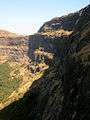
Alang Fort (also Alangad) is a fort in Nashik district, Maharashtra, India. It is one of the three forts, the others being Madangad and Kulang, in the Kalsubai range of the Western Ghats. They are the most difficult to reach forts in Nasik District. A dense forest cover make these treks difficult. These three forts are a little neglected due to very heavy rains in the area and a difficult confusing path to the forts.
Fascinating Spots
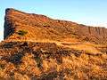
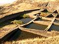
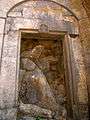
The top of the fort is a huge plateau. On the fort, there are two caves, a small temple and 11 water cisterns. Remnants of buildings are spread over the fort. Kalasubai, Aundh Fort, Patta and Bitangad are to the east of the fort, Harihar, Trymbakgad and Anjaneri to its north and Harishchandragad, Aajobagad, Khutta (pinnacle), Ratangad and Katrabai to its south.
Ways To Reach
Igatpuri/Kasara-Ghoti-Pimpalnermor-Ambevadi
To reach Alang, go to Kasara or Igatpuri and then Ambevadi by the Igatpuri/Kasara-Ghoti-Pimpalnermor route. There is a bus service from Ghoti to Ambevadi.. Ambevadi is 32 km away from Ghoti. A bus is available at 6 a.m. from Ghoti to Ambevadi. We can easily see Alang, Madan and Kulang from there. From Ambevadi, a way goes to the ridge between Alang and Madan, which may take up to 3 hours. From the ridge, the fort visible on the left is Alang, while the one on the right is Madan.
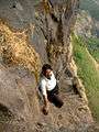
From there, two ways go towards Alang. a) One way descends from the ridge. Within 1 hour you can reach the plateau. Keeping Alang to your left, you will reach a cavern after about an hour's walk. From there, you can go higher by rock climbing. Then you will reach a flat patch. Keep left and proceed towards the pinnacle. After 10 to 15 minutes, you will come at a cave in the fort. Time required to reach here from Ambevadi is approximately 8 to 9 hours.
b) Proceed from the ridge and after easy rock climbing, you will come near few steps. After ascending these steps, climb a broken pinnacle of 80 to 90 ft. Only trained climbers should go this way. This way, you can reach the fort after 6 hours.
Ghatghar via Ghoti-Bhandardara
Another way towards fort is from Ghatghar. Go via Ghoti-Bhandardara. From there, in 2½ hours, one can come to the third cavern. Via Bhandardara from Udadvade. Another way towards the fort is via Bhandardara from Udadvade gaon. It takes us at the plateau and then connects to the second route.
Accommodation Facility
Two caves on the fort can accommodate 30-40 people.
Food Facility
You have to carry with your own.
Drinking Water Facility
Ample water is available in reservoirs in all seasons Still, we have to carry sufficient water till we reach the top.
Time To Reach
7–8 hours from Ambevadi