Ahmednagar district
| Ahmednagar district अहमदनगर जिल्हा | |
|---|---|
| District of Maharashtra | |
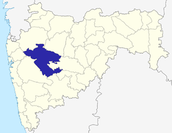 Location of Ahmednagar district in Maharashtra | |
| Country | India |
| State | Maharashtra |
| Administrative division | Nashik Division |
| Headquarters | Ahmednagar |
| Tehsils | Akole, Jamkhed, Karjat, Kopargaon, Nagar, Nevasa, Parner, Pathardi, Rahata, Rahuri, Sangamner, Shevgaon, Shrigonda, Shrirampur |
| Government | |
| • District collector | Mr. Anil Kawade, I.A.S. |
| • Lok Sabha constituencies | Ahmednagar, Shirdi (based on Election Commission website) |
| • Assembly seats | 13 |
| Area | |
| • Total | 17,413 km2 (6,723 sq mi) |
| Population (2011) | |
| • Total | 4,543,080 |
| • Density | 260/km2 (680/sq mi) |
| • Urban | 17.67% |
| Demographics | |
| • Literacy | 90.22% |
| • Sex ratio | 934 |
| Vehicle registration | MH-16 and MH-17 |
| Major highways | NH-50, NH-222 |
| Average annual precipitation | 501 mm |
| Website | Official website |
Ahmednagar district is the largest district of Maharashtra state in western India. The historical Ahmednagar city is the headquarters of the district. Ahmednagar was the seat of the Ahmednagar Sultanate of late medieval period (1496–1636 CE). This district is known for the towns of Shirdi associated with Sai Baba and Meherabad associated with Meher Baba. Ahmednagar district is part of Nashik Division.
The neighbouring districts to Ahmednagar district are Solapur (South East- SE), Osmanabad (SE), Beed (SE), Aurangabad (NE), Nashik (NW), Thane (NW), and Pune (SW).
History
Although Ahmadnagar district was created as early as in 1818, modern history of Ahmadnagar may be said to have commenced from 1869, the year in which parts of Nasik and Sholapur which till then had comprised Nagar were separated and the present Nagar district was formed. Ahmednagar District was created after the defeat of the Maratha Confederacy in the Third Anglo-Maratha War in 1818, when most of the Peshwa's domains were annexed to British India. The district remained part of the Central division of Bombay Presidency until India's independence in 1947, when it became part of Bombay State, and in 1960 the new state of Maharashtra.
Economy
In 2006 the Ministry of Panchayati Raj named Ahmednagar one of the country's 250 most backward districts (out of a total of 640).[1] It is one of the twelve districts in Maharashtra currently receiving funds from the Backward Regions Grant Fund Programme (BRGF).[1]
Ahmednagar is Maharashtra’s most advanced district in many ways. It has the maximum number of sugar factories, perhaps to spread the message of “Rural Prosperity through Cooperation” it gave the country half a century ago. The first cooperative sugar factory in Asia was established at Pravanagar. A role model of water conservation work can be seen at Ralegaon-Siddhi, which is also called the Ideal Village. Newase where Dnyaneshwari was written, Shri Saibaba’s Shirdi, one of Ashtavinayaks at Siddhatek, the famous Kanifnath temple, attract devotees. The Palace of Chandbibi, the Bhandardara dam, the Maldhok (Indian Bustard) sanctuary and the Rehkuri sanctuary are some of the places of tourist attraction.
Divisions
Ahmednagar district consists of fourteen talukas. These talukas are
Ahmednagar district has twelve Vidhan Sabha constituencies, six in each of the two parliamentary constituencies.
- For the Shirdi Parliamentary Constituency (SC)
- #222 Shevgaon
- #223 Rahuri
- #224 Parner
- #225 Ahmednagar City
- #226 Shrigonda
- #227 Karjat-Jamkhed.[3][4]
The Ahmednagar district is under proposal to be divided and a separate Sangamner District or Shrirampur District be carved out of existing Ahmednagar district with the inclusion of the northern parts of Ahmednagar district which include Rahata, Rahuri, Shrirampur, Sangamner, Akole, Kopargaon, and Nevasa talukas in the proposed Sangamner or Shrirampur district. Sangamner is much developed city than Shrirampur.
Ralegaon Siddhi is a village in the district that is considered a model of environmental conservation.[5]
Demographics
In the 2001 India census, Ahmednagar district had a population of 4,040,642.[6] At that time the district was 19.89% urban.[6] Males represented 51.55% of the population, and females 48.45%, for a sex-ratio of 940 females per thousand males in 2001.[6]
In the 2001 census, the majority of the population in Ahmednagar was Hindu, but there were other religious groups such as Christians, Muslims, Sikhs, Buddhists, Jains and Zoroastrians in smaller numbers. According to census, Hindus were 84%, Muslims 7%, Christians 4% and others were 4%.[7]
In the 2011 census Ahmednagar district recorded a population of 4,543,083,[8] roughly equal to the nation of Costa Rica[9] or the US state of Louisiana.[10] This gave it a ranking of 33rd among the districts of India (out of a total of 640).[8] The district had a population density of 266 inhabitants per square kilometre (690/sq mi).[8] Its population growth rate over the decade 2001-2011 was 12.43%.[8] Ahmadnagar had a sex ratio of 934 females for every 1000 males,[8] and a literacy rate of 80.22%.[8]
Culture
Islam arrived in Ahmednagar during the Tughlaq dynasty. There are many Muslim monuments like Chand Bibi Mahal, Faria Baug, Ground Fort and many dargas (mosques), and they are found in main town and cities.
Christianity arrived in the 18th century when the British took over the area from the Maratha empire onwards. Christianity has been Ahmednagar's third-largest religion, found all over the district except in the south-west. In Ahmednagar Christians are Hindu converts and many Christians are a result of the American Marathi mission and the mission of the Church of England's Society for the Propagation of the Gospel.[11] During the British era Ahmednagar was part of Bombay presidency. The first Protestant Christian mission in the district was opened in 1831. Every village has one or more resident families as Christian and every village has its own church for worship.[12] Ahmednagar's Christians are called Marathi Christians and a majority of them are Protestants, plus large scale of Banjara communities[13]
Personalities
- Shankarrao Kale
- Anna Hazare
- B. J. Khatal-Patil- Ex. Cabinet Minister of Maharashtra, a senior Maharashtra leader and a veteran Congressman.
- Bhausaheb Thorat (12 Jan 1924-14 Mar 2010), a leader of farmers and Indian National Congress legislator. He was well known in the cooperative movement, founder of the Sangamner Cooperative Sugar Mill, and former president of the Sangamner taluka and State Cooperative Bank. He is recognized for his work in Sangamner taluka and Akole taluka. Concerned about global warming, Bhausaheb Thorat has led a campaign to plant 45 million trees every year. In the epic Ramayana, the sage Agastya turned the arid Dandakaranya into a green heaven through a massive drive of tree planting. A book, The Man Who Planted Trees, an allegorical tale by French author Jean Giono, also inspired Bhausaheb Thorat. For this, he started the Dandakaranya Abhiyaan in June 2006 at Sangamner.[14]
- Dagdu Maruti Pawar (1935–1996), a Marathi author and poet known for his contributions to Dalit literature.[15] He was born in Dhamangaon, Akole taluka.
- Zaheer Khan, Indian Cricketer born on Shrirampur City on 7 October 1978, who has been a Key member of the Indian cricket team since 2000. He also played for Worcestershire in County Cricket and plays for Mumbai in Indian domestic cricket. He is currently the second-most successful Indian pace bowler in Test match cricket, behind Kapil Dev.
- Balasaheb Bharde (1912–2006), Former Minister, former speaker of the State Legislative Assembly and Padma Bhushan recipi
Popatrao Pawar
References
- 1 2 Ministry of Panchayati Raj (September 8, 2009). "A Note on the Backward Regions Grant Fund Programme" (PDF). National Institute of Rural Development. Retrieved September 27, 2011.
- ↑ "Tahsil Information". Ahmednagar District. Archived from the original on 10 April 2009.
- ↑ "Map of Parliamentary and Assembly Constituencies within Ahmednagar District".
- ↑ "Delimitation of Parliamentary and Assembly Constituencies Order, 2008" (PDF). The Election Commission of India. pp. 269–270, 278.
- ↑ "A model Indian village- Ralegaon Siddhi". Archived from the original on 11 October 2006. Retrieved 2006-10-30.
- 1 2 3 "Census 2001 Population Finder: Maharashtra: Ahmadnagar". Office of The Registrar General & Census Commissioner, Ministry of Home Affairs, Government of India.
- ↑ "Census of India 2001: Data from the 2001 Census, including cities, villages and towns (Provisional)". Census Commission of India. Archived from the original on 2004-06-16. Retrieved 2008-11-01.
- 1 2 3 4 5 6 "District Census 2011: Ahmadnagar". Registrar General & Census Commissioner, India. 2011. Archived from the original on 8 September 2011.
- ↑ US Directorate of Intelligence. "Country Comparison:Population". Retrieved 2011-10-01.
Costa Rica 4,576,562 July 2011 est
- ↑ "2010 Resident Population Data". U. S. Census Bureau. Archived from the original on 2010-12-25. Retrieved 2011-09-30.
Louisiana 4,533,372
- ↑ "A History of the Church of England in India, by Eyre Chatterton (1924)". Anglicanhistory.org. Retrieved 2012-11-07.
- ↑ "The Gazetteers Department - AHMADNAGAR". Ahmednagar.nic.in. Retrieved 2012-11-07.
- ↑ "The Gazetteers Department - AHMADNAGAR". Ahmednagar.nic.in. Retrieved 2012-11-07.
- ↑
- Rev. D. S. Salvi- A missionary who was involved in Farmers development work, through his charitable organization, FEADER India.He built the road connection Rahuri to Taharbad and Taharabad to Rahuri Factory so that the farmers and the shepherd community could be connected to the markets in Rahuri and Factory.
- ↑ Anna Kurian (2006). Texts and Their Worlds I: Literatures of India - An Introduction. Lincoln, Neb: Foundation Books. ISBN 81-7596-300-X.
https://cultural.maharashtra.gov.in/english/gazetteer/Ahmadnagar/about_ahmadnagar.html
External links
- Travel to Ahmednagar
- Pictures of Ahmednagar
- Some more vintage pictures of Ahmednagar city
- Ahmednagar Directory
 |
Thane district | Nashik district | Aurangabad district | |
| Thane district/Pune district | |
Beed district | ||
| ||||
| | ||||
| Pune district | Solapur district | Osmanabad district |
| Topics | |||||||||||||||||||||||
|---|---|---|---|---|---|---|---|---|---|---|---|---|---|---|---|---|---|---|---|---|---|---|---|
| Regions | |||||||||||||||||||||||
| Divisions and Districts |
| ||||||||||||||||||||||
| Million-plus cities in Maharashtra | |||||||||||||||||||||||
| Other cities with municipal corporations | |||||||||||||||||||||||
Portal: Maharashtra | |||||||||||||||||||||||
| Rivers |
|    | |||||||||||||||||||||||||
|---|---|---|---|---|---|---|---|---|---|---|---|---|---|---|---|---|---|---|---|---|---|---|---|---|---|---|---|
| Dams, barrages | |||||||||||||||||||||||||||
| Geographical features / regions | |||||||||||||||||||||||||||
| Riparian districts |
| ||||||||||||||||||||||||||
| Cities | |||||||||||||||||||||||||||
| Languages / people | |||||||||||||||||||||||||||
| Coalfields | |||||||||||||||||||||||||||
| Oil / gas fields | |||||||||||||||||||||||||||
| Industries |
| ||||||||||||||||||||||||||
| Transport | |||||||||||||||||||||||||||
| Related topics | |||||||||||||||||||||||||||
| Other basins | |||||||||||||||||||||||||||
Coordinates: 19°05′53″N 74°43′57″E / 19.09806°N 74.73250°E