Audenge
| Audenge | ||
|---|---|---|
|
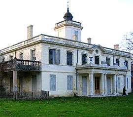
Chateau of Certes | ||
| ||
 Audenge | ||
|
Location within Nouvelle-Aquitaine region  Audenge | ||
| Coordinates: 44°41′05″N 1°00′43″W / 44.6847°N 1.0119°WCoordinates: 44°41′05″N 1°00′43″W / 44.6847°N 1.0119°W | ||
| Country | France | |
| Region | Nouvelle-Aquitaine | |
| Department | Gironde | |
| Arrondissement | Arcachon | |
| Canton | Audenge | |
| Intercommunality | Bassin d'Arcachon Nord Atlantique | |
| Government | ||
| • Mayor (2008–2014) | Nathalie Le Yondre | |
| Area1 | 82.09 km2 (31.70 sq mi) | |
| Population (2008)2 | 5,736 | |
| • Density | 70/km2 (180/sq mi) | |
| Time zone | CET (UTC+1) | |
| • Summer (DST) | CEST (UTC+2) | |
| INSEE/Postal code | 33019 / 33980 | |
| Elevation |
0–59 m (0–194 ft) (avg. 7 m or 23 ft) | |
|
1 French Land Register data, which excludes lakes, ponds, glaciers > 1 km² (0.386 sq mi or 247 acres) and river estuaries. 2 Population without double counting: residents of multiple communes (e.g., students and military personnel) only counted once. | ||
.svg.png)
Audenge is a commune in the Gironde department in southwestern France.
Geography
The town is situated on the Bassin d'Arcachon, between Lanton, Biganos and Marcheprime.
Population
| Historical population | ||
|---|---|---|
| Year | Pop. | ±% |
| 1793 | 732 | — |
| 1800 | 800 | +9.3% |
| 1806 | 842 | +5.2% |
| 1821 | 870 | +3.3% |
| 1831 | 1,148 | +32.0% |
| 1836 | 1,092 | −4.9% |
| 1841 | 1,078 | −1.3% |
| 1846 | 1,113 | +3.2% |
| 1851 | 1,124 | +1.0% |
| 1856 | 1,133 | +0.8% |
| 1861 | 1,173 | +3.5% |
| 1866 | 1,225 | +4.4% |
| 1872 | 1,071 | −12.6% |
| 1876 | 1,174 | +9.6% |
| 1881 | 1,220 | +3.9% |
| 1886 | 1,288 | +5.6% |
| 1891 | 1,297 | +0.7% |
| 1896 | 1,366 | +5.3% |
| 1901 | 1,364 | −0.1% |
| 1906 | 1,376 | +0.9% |
| 1911 | 1,344 | −2.3% |
| 1921 | 1,433 | +6.6% |
| 1926 | 1,540 | +7.5% |
| 1931 | 1,652 | +7.3% |
| 1936 | 1,781 | +7.8% |
| 1946 | 1,772 | −0.5% |
| 1954 | 1,964 | +10.8% |
| 1962 | 2,001 | +1.9% |
| 1968 | 2,234 | +11.6% |
| 1975 | 2,529 | +13.2% |
| 1982 | 2,675 | +5.8% |
| 1990 | 2,981 | +11.4% |
| 1999 | 3,948 | +32.4% |
| 2008 | 5,736 | +45.3% |
Inhabitants of Audenge are called Audengeois.
History
Audenge's patron saint is Saint Yves, patron of fishermen.
See also
References
| Wikimedia Commons has media related to Audenge. |
This article is issued from Wikipedia - version of the 7/21/2016. The text is available under the Creative Commons Attribution/Share Alike but additional terms may apply for the media files.