Saint-Vincent-de-Pertignas
| Saint-Vincent-de-Pertignas | |
|---|---|
 | |
 Saint-Vincent-de-Pertignas | |
|
Location within Nouvelle-Aquitaine region  Saint-Vincent-de-Pertignas | |
| Coordinates: 44°47′54″N 0°06′39″W / 44.7983°N 0.1108°WCoordinates: 44°47′54″N 0°06′39″W / 44.7983°N 0.1108°W | |
| Country | France |
| Region | Nouvelle-Aquitaine |
| Department | Gironde |
| Arrondissement | Libourne |
| Canton | Pujols |
| Intercommunality | Castillon Pujols |
| Government | |
| • Mayor (2008–2014) | Pierre Gauthier |
| Area1 | 7.61 km2 (2.94 sq mi) |
| Population (2008)2 | 344 |
| • Density | 45/km2 (120/sq mi) |
| Time zone | CET (UTC+1) |
| • Summer (DST) | CEST (UTC+2) |
| INSEE/Postal code | 33488 / 33420 |
| Elevation |
2–88 m (6.6–288.7 ft) (avg. 61 m or 200 ft) |
|
1 French Land Register data, which excludes lakes, ponds, glaciers > 1 km² (0.386 sq mi or 247 acres) and river estuaries. 2 Population without double counting: residents of multiple communes (e.g., students and military personnel) only counted once. | |
Saint-Vincent-de-Pertignas is a commune in the Gironde department in Nouvelle-Aquitaine in southwestern France.
Population
| Historical population | ||
|---|---|---|
| Year | Pop. | ±% |
| 1962 | 436 | — |
| 1968 | 442 | +1.4% |
| 1975 | 382 | −13.6% |
| 1982 | 396 | +3.7% |
| 1990 | 377 | −4.8% |
| 1999 | 369 | −2.1% |
| 2008 | 344 | −6.8% |
Geography
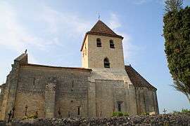
The commune contains a number of farms, vineyards, homes and a medieval church (pictured). It is a short walk to Rauzan, the next commune over, to the south. The ruins of the castle in Rauzan are visible from Saint-Vincent-de-Pertignas. The nearest train station from Saint-Vincent-de-Pertignas is located in Libourne. Saint-Vincent-de-Pertignas is bounded to the north by Dordogne and the Gamage river.
History
A cemetery that dates to the Merovingian dynasty was discovered in the commune's heart in 1986, showing that Saint-Vincent-de-Pertignas has been inhabited for a great length of time.
See also
References
| Wikimedia Commons has media related to Saint-Vincent-de-Pertignas. |