Rauzan
| Rauzan | ||
|---|---|---|
|
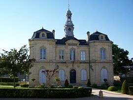
Town hall | ||
| ||
 Rauzan | ||
|
Location within Nouvelle-Aquitaine region  Rauzan | ||
| Coordinates: 44°46′47″N 0°07′25″W / 44.7797°N 0.1236°WCoordinates: 44°46′47″N 0°07′25″W / 44.7797°N 0.1236°W | ||
| Country | France | |
| Region | Nouvelle-Aquitaine | |
| Department | Gironde | |
| Arrondissement | Libourne | |
| Canton | Pujols | |
| Intercommunality | Castillon Pujols | |
| Government | ||
| • Mayor (2008–2014) | Gérard César | |
| Area1 | 6.5 km2 (2.5 sq mi) | |
| Population (2008)2 | 1,134 | |
| • Density | 170/km2 (450/sq mi) | |
| Time zone | CET (UTC+1) | |
| • Summer (DST) | CEST (UTC+2) | |
| INSEE/Postal code | 33350 / 33420 | |
| Elevation |
5–100 m (16–328 ft) (avg. 75 m or 246 ft) | |
|
1 French Land Register data, which excludes lakes, ponds, glaciers > 1 km² (0.386 sq mi or 247 acres) and river estuaries. 2 Population without double counting: residents of multiple communes (e.g., students and military personnel) only counted once. | ||
.svg.png)
Rauzan is a commune in the Gironde department in Nouvelle-Aquitaine in southwestern France. It contains the ruins of a castle, the Château de Rauzan, a tourist attraction.
Population
| Historical population | ||
|---|---|---|
| Year | Pop. | ±% |
| 1962 | 841 | — |
| 1968 | 858 | +2.0% |
| 1975 | 903 | +5.2% |
| 1982 | 888 | −1.7% |
| 1990 | 978 | +10.1% |
| 1999 | 1,035 | +5.8% |
| 2008 | 1,134 | +9.6% |
See also
References
| Wikimedia Commons has media related to Rauzan. |
This article is issued from Wikipedia - version of the 11/9/2016. The text is available under the Creative Commons Attribution/Share Alike but additional terms may apply for the media files.