Saint-Pierre-de-Bat
| Saint-Pierre-de-Bat | |
|---|---|
|
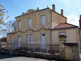
Town hall | |
 Saint-Pierre-de-Bat | |
|
Location within Nouvelle-Aquitaine region  Saint-Pierre-de-Bat | |
| Coordinates: 44°40′24″N 0°13′54″W / 44.6733°N 0.2317°WCoordinates: 44°40′24″N 0°13′54″W / 44.6733°N 0.2317°W | |
| Country | France |
| Region | Nouvelle-Aquitaine |
| Department | Gironde |
| Arrondissement | Langon |
| Canton | Targon |
| Intercommunality | Targonnais |
| Government | |
| • Mayor (2008–2014) | Pilippe Acker |
| Area1 | 8.96 km2 (3.46 sq mi) |
| Population (2008)2 | 309 |
| • Density | 34/km2 (89/sq mi) |
| Time zone | CET (UTC+1) |
| • Summer (DST) | CEST (UTC+2) |
| INSEE/Postal code | 33464 / 33760 |
|
1 French Land Register data, which excludes lakes, ponds, glaciers > 1 km² (0.386 sq mi or 247 acres) and river estuaries. 2 Population without double counting: residents of multiple communes (e.g., students and military personnel) only counted once. | |
Saint-Pierre-de-Bat is a commune in the Gironde department in Nouvelle-Aquitaine in southwestern France.
Population
| Historical population | ||
|---|---|---|
| Year | Pop. | ±% |
| 1793 | 537 | — |
| 1800 | 454 | −15.5% |
| 1806 | 611 | +34.6% |
| 1821 | 529 | −13.4% |
| 1831 | 391 | −26.1% |
| 1836 | 448 | +14.6% |
| 1841 | 450 | +0.4% |
| 1846 | 462 | +2.7% |
| 1851 | 471 | +1.9% |
| 1856 | 451 | −4.2% |
| 1861 | 470 | +4.2% |
| 1866 | 440 | −6.4% |
| 1872 | 445 | +1.1% |
| 1876 | 464 | +4.3% |
| 1881 | 423 | −8.8% |
| 1886 | 426 | +0.7% |
| 1891 | 357 | −16.2% |
| 1896 | 397 | +11.2% |
| 1901 | 422 | +6.3% |
| 1906 | 364 | −13.7% |
| 1911 | 374 | +2.7% |
| 1921 | 345 | −7.8% |
| 1926 | 310 | −10.1% |
| 1931 | 317 | +2.3% |
| 1936 | 329 | +3.8% |
| 1946 | 315 | −4.3% |
| 1954 | 313 | −0.6% |
| 1962 | 278 | −11.2% |
| 1968 | 256 | −7.9% |
| 1975 | 253 | −1.2% |
| 1982 | 264 | +4.3% |
| 1990 | 251 | −4.9% |
| 1999 | 271 | +8.0% |
| 2008 | 309 | +14.0% |
See also
References
| Wikimedia Commons has media related to Saint-Pierre-de-Bat. |
This article is issued from Wikipedia - version of the 11/9/2016. The text is available under the Creative Commons Attribution/Share Alike but additional terms may apply for the media files.