Abzac, Gironde
| Abzac | ||
|---|---|---|
|
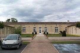
Town hall | ||
| ||
 Abzac | ||
|
Location within Nouvelle-Aquitaine region  Abzac | ||
| Coordinates: 45°01′03″N 0°07′34″W / 45.0175°N 0.126°WCoordinates: 45°01′03″N 0°07′34″W / 45.0175°N 0.126°W | ||
| Country | France | |
| Region | Nouvelle-Aquitaine | |
| Department | Gironde | |
| Arrondissement | Libourne | |
| Canton | Coutras | |
| Intercommunality | Pays de Coutras | |
| Government | ||
| • Mayor (2008–2014) | Jean-Louis d'Anglade | |
| Area1 | 13.44 km2 (5.19 sq mi) | |
| Population (2012)2 | 1,858 | |
| • Density | 140/km2 (360/sq mi) | |
| Time zone | CET (UTC+1) | |
| • Summer (DST) | CEST (UTC+2) | |
| INSEE/Postal code | 33001 / 33230 | |
| Elevation |
5–65 m (16–213 ft) (avg. 55 m or 180 ft) | |
|
1 French Land Register data, which excludes lakes, ponds, glaciers > 1 km² (0.386 sq mi or 247 acres) and river estuaries. 2 Population without double counting: residents of multiple communes (e.g., students and military personnel) only counted once. | ||
.svg.png)
Abzac is a commune in the Gironde department in southwestern Metropolitan France.
Population
| Historical population | ||
|---|---|---|
| Year | Pop. | ±% |
| 1793 | 1,354 | — |
| 1800 | 1,370 | +1.2% |
| 1806 | 1,282 | −6.4% |
| 1821 | 1,383 | +7.9% |
| 1831 | 1,520 | +9.9% |
| 1836 | 1,511 | −0.6% |
| 1841 | 1,503 | −0.5% |
| 1846 | 1,521 | +1.2% |
| 1851 | 1,505 | −1.1% |
| 1856 | 1,464 | −2.7% |
| 1861 | 1,398 | −4.5% |
| 1866 | 1,341 | −4.1% |
| 1872 | 1,362 | +1.6% |
| 1876 | 1,463 | +7.4% |
| 1881 | 1,620 | +10.7% |
| 1886 | 1,585 | −2.2% |
| 1891 | 1,606 | +1.3% |
| 1896 | 1,626 | +1.2% |
| 1901 | 1,596 | −1.8% |
| 1906 | 1,565 | −1.9% |
| 1911 | 1,509 | −3.6% |
| 1921 | 1,433 | −5.0% |
| 1926 | 1,504 | +5.0% |
| 1931 | 1,444 | −4.0% |
| 1936 | 1,485 | +2.8% |
| 1946 | 1,363 | −8.2% |
| 1954 | 1,399 | +2.6% |
| 1962 | 1,452 | +3.8% |
| 1968 | 1,474 | +1.5% |
| 1975 | 1,426 | −3.3% |
| 1982 | 1,475 | +3.4% |
| 1990 | 1,472 | −0.2% |
| 1999 | 1,598 | +8.6% |
| 2008 | 1,739 | +8.8% |
See also
References
| Wikimedia Commons has media related to Abzac (Gironde). |
This article is issued from Wikipedia - version of the 2/12/2016. The text is available under the Creative Commons Attribution/Share Alike but additional terms may apply for the media files.