Lège-Cap-Ferret
| Lège-Cap-Ferret | ||
|---|---|---|
 | ||
| ||
 Lège-Cap-Ferret | ||
|
Location within Nouvelle-Aquitaine region  Lège-Cap-Ferret | ||
| Coordinates: 44°47′38″N 1°08′43″W / 44.7939°N 1.1453°WCoordinates: 44°47′38″N 1°08′43″W / 44.7939°N 1.1453°W | ||
| Country | France | |
| Region | Nouvelle-Aquitaine | |
| Department | Gironde | |
| Arrondissement | Arcachon | |
| Canton | Audenge | |
| Intercommunality | Bassin d'Arcachon Nord Atlantique | |
| Government | ||
| • Mayor (2001–2008) | Michel Sammarcelli | |
| Area1 | 93.62 km2 (36.15 sq mi) | |
| Population (2008)2 | 7,396 | |
| • Density | 79/km2 (200/sq mi) | |
| Time zone | CET (UTC+1) | |
| • Summer (DST) | CEST (UTC+2) | |
| INSEE/Postal code | 33236 / 33950 | |
| Elevation |
0–43 m (0–141 ft) (avg. 11 m or 36 ft) | |
|
1 French Land Register data, which excludes lakes, ponds, glaciers > 1 km² (0.386 sq mi or 247 acres) and river estuaries. 2 Population without double counting: residents of multiple communes (e.g., students and military personnel) only counted once. | ||
.svg.png)
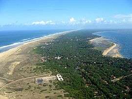
Lège-Cap-Ferret (Gascon: Lèja e lo Horet) is a commune in the Gironde department in Nouvelle-Aquitaine in southwestern France. The commune stretches along the length of the Cap Ferret peninsula, from the village of Lège in the north to the point of Cap Ferret in the south.
Population
| Historical population | ||
|---|---|---|
| Year | Pop. | ±% |
| 1962 | 3,605 | — |
| 1968 | 4,232 | +17.4% |
| 1975 | 4,318 | +2.0% |
| 1982 | 4,981 | +15.4% |
| 1990 | 5,564 | +11.7% |
| 1999 | 6,307 | +13.4% |
| 2008 | 7,396 | +17.3% |
Climate
| Climate data for Lège-Cap-Ferret (1961–1990) | |||||||||||||
|---|---|---|---|---|---|---|---|---|---|---|---|---|---|
| Month | Jan | Feb | Mar | Apr | May | Jun | Jul | Aug | Sep | Oct | Nov | Dec | Year |
| Average high °C (°F) | 10.2 (50.4) |
11.6 (52.9) |
13.5 (56.3) |
15.9 (60.6) |
19.1 (66.4) |
22.0 (71.6) |
24.7 (76.5) |
24.5 (76.1) |
22.9 (73.2) |
19.1 (66.4) |
13.9 (57) |
10.8 (51.4) |
17.4 (63.3) |
| Daily mean °C (°F) | 7.3 (45.1) |
8.3 (46.9) |
9.8 (49.6) |
12.1 (53.8) |
15.1 (59.2) |
18.1 (64.6) |
20.5 (68.9) |
20.5 (68.9) |
18.7 (65.7) |
15.4 (59.7) |
10.6 (51.1) |
7.9 (46.2) |
13.7 (56.7) |
| Average low °C (°F) | 4.4 (39.9) |
5.1 (41.2) |
6.1 (43) |
8.2 (46.8) |
11.2 (52.2) |
14.1 (57.4) |
16.3 (61.3) |
16.4 (61.5) |
14.5 (58.1) |
11.6 (52.9) |
7.4 (45.3) |
5.0 (41) |
10.0 (50) |
| Average precipitation mm (inches) | 88.2 (3.472) |
75.1 (2.957) |
66.4 (2.614) |
64.7 (2.547) |
66.8 (2.63) |
47.1 (1.854) |
38.1 (1.5) |
53.0 (2.087) |
74.4 (2.929) |
83.2 (3.276) |
93.1 (3.665) |
95.5 (3.76) |
845.6 (33.291) |
| Average relative humidity (%) | 88 | 85 | 81 | 80 | 79 | 80 | 78 | 79 | 80 | 84 | 87 | 88 | 82.4 |
| Mean monthly sunshine hours | 90.8 | 113.2 | 171.4 | 201.0 | 233.7 | 258.4 | 287.2 | 260.0 | 212.5 | 170.6 | 109.6 | 88.1 | 2,196.5 |
| Source: Infoclimat.fr[1] | |||||||||||||
International relations
The commune is twinned with:
 Sandhausen, Baden-Württemberg, Germany, since 1980
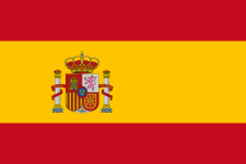 Úbeda, Jaén, Andalusia, Spain, since 1983
See also
References
- ↑ "Normes et records 1961-1990: Lège - Cap Ferret (33) - altitude 9m" (in French). Infoclimat. Retrieved December 28, 2015.
| Wikimedia Commons has media related to Lège-Cap-Ferret. |
This article is issued from Wikipedia - version of the 11/30/2016. The text is available under the Creative Commons Attribution/Share Alike but additional terms may apply for the media files.