Beuil
| Beuil | ||
|---|---|---|
|
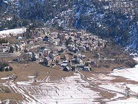
A general view of the village, from above | ||
| ||
 Beuil | ||
|
Location within Provence-A.-C.d'A. region  Beuil | ||
| Coordinates: 44°05′45″N 6°59′18″E / 44.0958°N 6.9883°ECoordinates: 44°05′45″N 6°59′18″E / 44.0958°N 6.9883°E | ||
| Country | France | |
| Region | Provence-Alpes-Côte d'Azur | |
| Department | Alpes-Maritimes | |
| Arrondissement | Nice | |
| Canton | Guillaumes | |
| Intercommunality | Cians Var | |
| Government | ||
| • Mayor (2014–2020) | Stéphane Simonini | |
| Area1 | 75.65 km2 (29.21 sq mi) | |
| Population (2009)2 | 493 | |
| • Density | 6.5/km2 (17/sq mi) | |
| Time zone | CET (UTC+1) | |
| • Summer (DST) | CEST (UTC+2) | |
| INSEE/Postal code | 06016 / 06470 | |
| Elevation | 1,040–2,815 m (3,412–9,236 ft) | |
|
1 French Land Register data, which excludes lakes, ponds, glaciers > 1 km² (0.386 sq mi or 247 acres) and river estuaries. 2 Population without double counting: residents of multiple communes (e.g., students and military personnel) only counted once. | ||

Beuil (Occitan: Buelh) is a commune in the Alpes-Maritimes department in southeastern France.
Geography
Beuil is a picturesque village located in the Maritime Alps, 78 km (48 mi) away from Nice. It is the gateway to the Mercantour National Park. A stop-off in the Red-rocked Gorges of the Cians and Daluis.
The commune is traversed by the Raton River.
Population
| Historical population | ||
|---|---|---|
| Year | Pop. | ±% |
| 1968 | 326 | — |
| 1975 | 320 | −1.8% |
| 1982 | 313 | −2.2% |
| 1990 | 330 | +5.4% |
| 1999 | 334 | +1.2% |
| 2008 | 493 | +47.6% |
See also
References
External links
| Wikimedia Commons has media related to Beuil. |
This article is issued from Wikipedia - version of the 12/3/2016. The text is available under the Creative Commons Attribution/Share Alike but additional terms may apply for the media files.