Spéracèdes
| Spéracèdes | ||
|---|---|---|
|
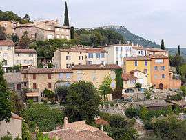
View of the village towards Cabris | ||
| ||
 Spéracèdes | ||
|
Location within Provence-A.-C.d'A. region  Spéracèdes | ||
| Coordinates: 43°38′58″N 6°51′34″E / 43.6494°N 6.8594°ECoordinates: 43°38′58″N 6°51′34″E / 43.6494°N 6.8594°E | ||
| Country | France | |
| Region | Provence-Alpes-Côte d'Azur | |
| Department | Alpes-Maritimes | |
| Arrondissement | Grasse | |
| Canton | Saint-Vallier-de-Thiey | |
| Government | ||
| • Mayor (2008–2014) | Joël Pasquelin | |
| Area1 | 3.46 km2 (1.34 sq mi) | |
| Population (2008)2 | 1,191 | |
| • Density | 340/km2 (890/sq mi) | |
| Time zone | CET (UTC+1) | |
| • Summer (DST) | CEST (UTC+2) | |
| INSEE/Postal code | 06137 / 06530 | |
| Elevation |
204–790 m (669–2,592 ft) (avg. 390 m or 1,280 ft) | |
|
1 French Land Register data, which excludes lakes, ponds, glaciers > 1 km² (0.386 sq mi or 247 acres) and river estuaries. 2 Population without double counting: residents of multiple communes (e.g., students and military personnel) only counted once. | ||

Spéracèdes is a commune in the Alpes-Maritimes department in southeastern France.
Population
Residents are called "Spéracèdois".
| Historical population | ||
|---|---|---|
| Year | Pop. | ±% |
| 1962 | 440 | — |
| 1968 | 531 | +20.7% |
| 1975 | 674 | +26.9% |
| 1982 | 764 | +13.4% |
| 1990 | 1,029 | +34.7% |
| 1999 | 1,095 | +6.4% |
| 2008 | 1,191 | +8.8% |
See also
References
External links
- Commune's official website
- Commune's events, life, and news : "Spéracèdes Demain" association's website
| Wikimedia Commons has media related to Spéracèdes. |
This article is issued from Wikipedia - version of the 3/15/2016. The text is available under the Creative Commons Attribution/Share Alike but additional terms may apply for the media files.