Castellar, Alpes-Maritimes
| Castellar | ||
|---|---|---|
|
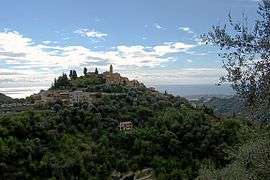
A general view of Castellar | ||
| ||
 Castellar | ||
|
Location within Provence-A.-C.d'A. region  Castellar | ||
| Coordinates: 43°48′16″N 7°29′50″E / 43.8044°N 7.4972°ECoordinates: 43°48′16″N 7°29′50″E / 43.8044°N 7.4972°E | ||
| Country | France | |
| Region | Provence-Alpes-Côte d'Azur | |
| Department | Alpes-Maritimes | |
| Arrondissement | Nice | |
| Canton | Menton-Est | |
| Government | ||
| • Mayor (2008–2014) | Huguette Layet | |
| Area1 | 12.24 km2 (4.73 sq mi) | |
| Population (2008)2 | 968 | |
| • Density | 79/km2 (200/sq mi) | |
| Time zone | CET (UTC+1) | |
| • Summer (DST) | CEST (UTC+2) | |
| INSEE/Postal code | 06035 / 06500 | |
| Elevation |
100–1,382 m (328–4,534 ft) (avg. 363 m or 1,191 ft) | |
|
1 French Land Register data, which excludes lakes, ponds, glaciers > 1 km² (0.386 sq mi or 247 acres) and river estuaries. 2 Population without double counting: residents of multiple communes (e.g., students and military personnel) only counted once. | ||

Castellar (Occitan: Castelar) is a commune in the Alpes-Maritimes department in southeastern France.
Population
| Historical population | ||
|---|---|---|
| Year | Pop. | ±% |
| 1962 | 279 | — |
| 1968 | 306 | +9.7% |
| 1975 | 353 | +15.4% |
| 1982 | 533 | +51.0% |
| 1990 | 638 | +19.7% |
| 1999 | 821 | +28.7% |
| 2008 | 968 | +17.9% |

See also
References
| Wikimedia Commons has media related to Castellar, Alpes-Maritimes. |
This article is issued from Wikipedia - version of the 12/3/2016. The text is available under the Creative Commons Attribution/Share Alike but additional terms may apply for the media files.