Pierlas
| Pierlas | ||
|---|---|---|
|
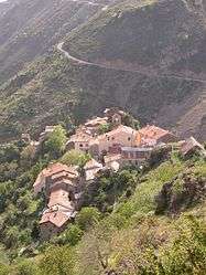
The village of Pierlas | ||
| ||
 Pierlas | ||
|
Location within Provence-A.-C.d'A. region  Pierlas | ||
| Coordinates: 44°01′57″N 7°02′10″E / 44.0325°N 7.0361°ECoordinates: 44°01′57″N 7°02′10″E / 44.0325°N 7.0361°E | ||
| Country | France | |
| Region | Provence-Alpes-Côte d'Azur | |
| Department | Alpes-Maritimes | |
| Arrondissement | Nice | |
| Canton | Villars-sur-Var | |
| Intercommunality | Vallées d'Azur | |
| Government | ||
| • Mayor (2008–2014) | Félix-Marius Bres | |
| Area1 | 31.31 km2 (12.09 sq mi) | |
| Population (2008)2 | 111 | |
| • Density | 3.5/km2 (9.2/sq mi) | |
| Time zone | CET (UTC+1) | |
| • Summer (DST) | CEST (UTC+2) | |
| INSEE/Postal code | 06096 / 06260 | |
| Elevation |
560–2,106 m (1,837–6,909 ft) (avg. 900 m or 3,000 ft) | |
|
1 French Land Register data, which excludes lakes, ponds, glaciers > 1 km² (0.386 sq mi or 247 acres) and river estuaries. 2 Population without double counting: residents of multiple communes (e.g., students and military personnel) only counted once. | ||

Pierlas is a commune in the Alpes-Maritimes department in southeastern France.
Geography
The commune is traversed by the Cians River.
Population
| Historical population | ||
|---|---|---|
| Year | Pop. | ±% |
| 1962 | 32 | — |
| 1968 | 62 | +93.8% |
| 1975 | 67 | +8.1% |
| 1982 | 73 | +9.0% |
| 1990 | 115 | +57.5% |
| 1999 | 84 | −27.0% |
| 2008 | 111 | +32.1% |
See also
References
| Wikimedia Commons has media related to Pierlas. |
This article is issued from Wikipedia - version of the 2/11/2016. The text is available under the Creative Commons Attribution/Share Alike but additional terms may apply for the media files.