Escragnolles
| Escragnolles | ||
|---|---|---|
|
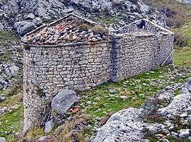
Chapel of Saint Martin | ||
| ||
 Escragnolles | ||
|
Location within Provence-A.-C.d'A. region  Escragnolles | ||
| Coordinates: 43°43′54″N 6°47′02″E / 43.7317°N 6.7839°ECoordinates: 43°43′54″N 6°47′02″E / 43.7317°N 6.7839°E | ||
| Country | France | |
| Region | Provence-Alpes-Côte d'Azur | |
| Department | Alpes-Maritimes | |
| Arrondissement | Grasse | |
| Canton | Saint-Vallier-de-Thiey | |
| Government | ||
| • Mayor (2008–2014) | Jacques Ballestra | |
| Area1 | 25.48 km2 (9.84 sq mi) | |
| Population (2008)2 | 545 | |
| • Density | 21/km2 (55/sq mi) | |
| Time zone | CET (UTC+1) | |
| • Summer (DST) | CEST (UTC+2) | |
| INSEE/Postal code | 06058 / 06460 | |
| Elevation | 400–1,644 m (1,312–5,394 ft) | |
|
1 French Land Register data, which excludes lakes, ponds, glaciers > 1 km² (0.386 sq mi or 247 acres) and river estuaries. 2 Population without double counting: residents of multiple communes (e.g., students and military personnel) only counted once. | ||

Escragnolles (Occitan: Escranhòla) is a commune in the Alpes-Maritimes department in southeastern France.
Geography
The commune is mountainous and includes the gorge of the Siagne.
Population
| Historical population | ||
|---|---|---|
| Year | Pop. | ±% |
| 1872 | 421 | — |
| 1881 | 310 | −26.4% |
| 1886 | 281 | −9.4% |
| 1891 | 277 | −1.4% |
| 1896 | 264 | −4.7% |
| 1901 | 283 | +7.2% |
| 1906 | 248 | −12.4% |
| 1911 | 249 | +0.4% |
| 1921 | 163 | −34.5% |
| 1926 | 156 | −4.3% |
| 1931 | 172 | +10.3% |
| 1936 | 130 | −24.4% |
| 1999 | 384 | +195.4% |
| 2008 | 545 | +41.9% |
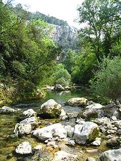
Gorge of the Siagne
See also
References
| Wikimedia Commons has media related to Escragnolles. |
This article is issued from Wikipedia - version of the 12/3/2016. The text is available under the Creative Commons Attribution/Share Alike but additional terms may apply for the media files.