Valderoure
| Valderoure | ||
|---|---|---|
|
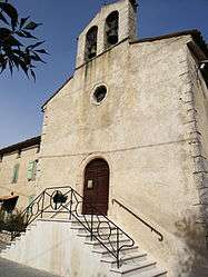
The church of Our Lady of the Assumption and Saint-Roch | ||
| ||
 Valderoure | ||
|
Location within Provence-A.-C.d'A. region  Valderoure | ||
| Coordinates: 43°47′51″N 6°42′39″E / 43.7975°N 6.7108°ECoordinates: 43°47′51″N 6°42′39″E / 43.7975°N 6.7108°E | ||
| Country | France | |
| Region | Provence-Alpes-Côte d'Azur | |
| Department | Alpes-Maritimes | |
| Arrondissement | Grasse | |
| Canton | Saint-Auban | |
| Intercommunality | Monts d'Azur | |
| Government | ||
| • Mayor (2008–2014) | Sylvain Buttelli | |
| Area1 | 25.34 km2 (9.78 sq mi) | |
| Population (2008)2 | 386 | |
| • Density | 15/km2 (39/sq mi) | |
| Time zone | CET (UTC+1) | |
| • Summer (DST) | CEST (UTC+2) | |
| INSEE/Postal code | 06154 / 06750 | |
| Elevation |
1,027–1,645 m (3,369–5,397 ft) (avg. 1,050 m or 3,440 ft) | |
|
1 French Land Register data, which excludes lakes, ponds, glaciers > 1 km² (0.386 sq mi or 247 acres) and river estuaries. 2 Population without double counting: residents of multiple communes (e.g., students and military personnel) only counted once. | ||
.svg.png)
Valderoure is a commune in the Alpes-Maritimes department in the Provence-Alpes-Côte d'Azur region in southeastern France.
Population
| Historical population | ||
|---|---|---|
| Year | Pop. | ±% |
| 1962 | 111 | — |
| 1968 | 132 | +18.9% |
| 1975 | 110 | −16.7% |
| 1982 | 167 | +51.8% |
| 1990 | 178 | +6.6% |
| 1999 | 306 | +71.9% |
| 2008 | 386 | +26.1% |
See also
Communes of the Alpes-Maritimes department
References
| Wikimedia Commons has media related to Valderoure. |
This article is issued from Wikipedia - version of the 1/30/2015. The text is available under the Creative Commons Attribution/Share Alike but additional terms may apply for the media files.