Bhagirathi River
| Bhāgīrathī River | |
 Sacred bathing ghats on Bhagirathi River at Gangotri | |
| Name origin: "Bhagirathi" (Sanskrit, literally, "caused by Bhagiratha") | |
| Country | |
|---|---|
| State | Uttarakhand, |
| Region | Garhwal division |
| District | Uttar Kashi District, Tehri District |
| Source | Gaumukh (gou, cow + mukh, face), about 18 km (11.2 mi) from the town of Gangotri |
| - elevation | 3,892 m (12,769 ft) |
| Source confluence | Alaknanda River |
| Mouth | Ganges |
| - location | Devprayag, Uttarakhand, India |
| - elevation | 475 m (1,558 ft) |
| Length | 205 km (127 mi) |
| Basin | 6,921 km2 (2,672 sq mi) |
| Discharge | |
| - average | 257.78 m3/s (9,103 cu ft/s) |
| - max | 3,800 m3/s (134,196 cu ft/s) |
 Map showing the Himalayan headwaters of the Bhagirathi river. The numbers in parentheses refer to the altitude in meters.
| |
| [1] | |
The Bhāgīrathī (Pron:/ˌbʌgɪˈɹɑːθɪ/) is a turbulent Himalayan river in the Indian states of Uttarakhand, and one of the two headstreams of the Ganges, the major river of Northern India and the holy river of Hinduism. In Hindu mythology and culture, the Bhagirathi is considered the source stream of the Ganges. However, in hydrology, the other headstream, Alaknanda, is considered the source stream on account of its great length and discharge.
Etymology
The word "Bhagirathi" (Sanskrit, literally, "caused by Bhagiratha") refers to a mythological Sagar Dynasty prince who, to gain the release his 60,000 great-uncles from the curse of saint Kapila, brought the goddess Ganga in the form of the river Ganges, from the heavens to the earth.[2] Bhagiratha was the king of Kosala, a kingdom in ancient India. He was a descendent of the great King Sagara of the Suryavanshi, or Surya Dynasty. He was one of the forefathers of Lord Rama, of the Ramayana, the epic in which Bhagiratha's tale is primarily recounted.[3]
Course
The headwaters of the Bhagirathi are formed at Gaumukh (elevation 3,892 metres (12,769 ft)), at the foot of the Gangotri glacier and Khatling glaciers in the Garhwal Himalaya. It is then joined by its tributaries; these are, in order from the source:
- Kedar Ganga at Gangotri (elevation 3,049 m (10,003 ft)),
- Jadh Ganga at Bhaironghati (elevation 2,650 m (8,690 ft)),
- Kakora Gad and Jalandhari Gad near Harsil (elevation 2,745 m (9,006 ft)),
- Siyan Gad near Jhala (elevation 2,575 m (8,448 ft)),
- Asi Ganganear Uttarkashi (elevation 1,158 m (3,799 ft)),
- Bhilangna River near Old Tehri (elevation 755 m (2,477 ft)).
The Bhilangna itself rises at the foot of the Khatling Glacier (elevation 3,717 m (12,195 ft)) approximately 50 km (31 mi) south of Gaumukh.
The river flows from its source for 205 km (127 mi) before meeting the Alaknanda River at an elevation of 475 m (1,558 ft) in the town of Devprayag. Downstream of this confluence, considered holy by Hindus, the river is known as the Ganga Ji, or Ganges River by westerners. The controversial Tehri dam lies at the confluence of the Bhāgirathi and the Bhilangna, at 30°22′32″N 78°28′48″E / 30.37556°N 78.48000°E, near Tehri. Chaukhamba I is the highest point of the Bhagirathi basin.
 The turbulent Bhāgīrathī as it enters Devprayag.
 The Bhagirathi (foreground) on its way to meet the sediment-laden
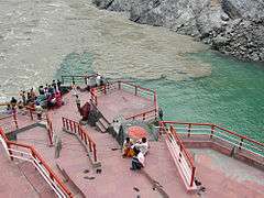
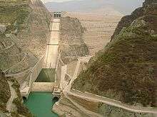 Tehri Dam, the 5th tallest dam in the world
Dams
There are 18 dams along the Bhāgirathi River, either in operation, under construction or planned. These are, in order from the source:
| # | Name | Ht | MW | Status | FRL | MWL | HRT | TRT | TWL | RBL | Coordinates |
|---|---|---|---|---|---|---|---|---|---|---|---|
| 1 | Karmoli Dam | 140 | planned | 8.6 | |||||||
| 2 | Gangotri Dam | 55 | planned | 5.2 | |||||||
| 3 | Jadhganga Dam | 50 | planned | 1.1 | |||||||
| 4 | Bhaironghati I Dam | 380 | planned | ||||||||
| 5 | Bhaironghati II Dam | 65 | planned | ||||||||
| 6 | Harsil Dam | 210 | planned | 5.06 | |||||||
| 7 | Loharinag Pala Dam | 600 | cancelled | 2,147 | 1,667 | 13.85 | .51 | 1.665 | 30°58′6″N 78°41′56″E / 30.96833°N 78.69889°E | ||
| 8 | Pala Maneri I Dam | 78 | 480 | cancelled | 1,665 | 1,667 | 12.563 | 1.378 | |||
| 9 | Maneri Dam | 38 | 90 | operation | 8.631 | ||||||
| 10 | Joshiyara (Bhali) Dam | 304 | operation | 16.0 | |||||||
| 11 | Bhilangana II Dam | 11 | planned | ||||||||
| 12 | Bhilangana I Dam | 22.5 | planned | 2.0 | |||||||
| 13 | Tehri Dam | 260.5 | 2,400 | operation | 830 | 835 | 1.634 | .8625 | 30°22′40″N 78°28′50″E / 30.37778°N 78.48056°E | ||
| 14 | Koteshwar Dam | 97.5 | 400 | operation | 612.50 | 615 | |||||
| 15 | Kotli Bel 1A Dam | 82.5 | 195 | construction | |||||||
| 16 | Kotli Bel 1B Dam | 90 | 320 | cancelled | |||||||
| 17 | Kotli Bel II Dam | 82 | 530 | cancelled | |||||||
Notes
- ↑ Catchment Area Treatment:, Bhagirathi River Valley Development Authority, Uttaranchal
- ↑ Mankodi, Kirit (1973) "Gaṅgā Tripathagā"Artibus Asiae 35(1/2): pp. 139-144, p. 140
- ↑ Gopal, Madan (1990). K.S. Gautam, ed. India through the ages. Publication Division, Ministry of Information and Broadcasting, Government of India. p. 76.
- ↑ "Map of the Bhagirathi River showing dams" (PDF). Dams, Rivers & People. South Asian Network on Dams Rivers & People(sandrp.in). August 2008. Retrieved 7 March 2010.
References
- Wilson,, W. (1860). A summer ramble in the Himalayas: with sporting adventures in the Vale of Cashmere. London: Hurst and Blackett. OCLC 58410561. available on microfilm
- Heske, Franz (1937). Im heiligen Lande der Gangesquellen (In the Holy Lands of the Source of the Ganges) (in German). Neudamm, Germany: J. Neumann. OCLC 35036471.
- Sharma, Man Mohan (1997). Through the Valley of Gods: Travels in the Central Himalayas (2 ed.). New Delhi: Vision Books. OCLC 4547622.
External links
| Wikimedia Commons has media related to Bhagirathi River. |