Boljevac
| Boljevac Бољевац | ||
|---|---|---|
| Municipality and Town | ||
| ||
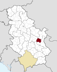 Location of the municipality of Boljevac within Serbia | ||
| Coordinates: 43°49′49.08″N 21°57′11.16″E / 43.8303000°N 21.9531000°ECoordinates: 43°49′49.08″N 21°57′11.16″E / 43.8303000°N 21.9531000°E | ||
| Country |
| |
| District | Zaječar | |
| Settlements | 20 | |
| Government | ||
| • Mayor | Nebojša Marjanović (DSS) | |
| Area[1] | ||
| • Municipality | 828 km2 (320 sq mi) | |
| Population (2011 census)[2] | ||
| • Town | 3,332 | |
| • Municipality | 12,865 | |
| Time zone | CET (UTC+1) | |
| • Summer (DST) | CEST (UTC+2) | |
| Postal code | 19370 | |
| Area code | +381 30 | |
| Car plates | ZA | |
| Website |
www | |

Boljevac (Serbian Cyrillic: Бољевац, pronounced [bɔ̌ːʎɛʋat͡s]) is a town and municipality located in the Zaječar District of Serbia. According to 2011 census, the population of the town is 3,332, while population of the municipality is 12,865.
History
From 1929 to 1941, Boljevac was part of the Morava Banovina of the Kingdom of Yugoslavia.
In 2010, the Commission on Concealed Mass Graves in Serbia discovered a mass grave of people killed by Yugoslav Partisans during World War II in the settlement of Zmijanac.[3] Partisan troops took over the municipality in October 1944. They subsequently executed over 40 locals, including a priest of the Serbian Orthodox Church.[4]
Demographics
The population of the municipality include 10,504 (66.28%) Serbs, 4,162 (26.26%) Vlachs, 229 (1.45%) Romani, etc.
Twin cities
References
- ↑ "Municipalities of Serbia, 2006". Statistical Office of Serbia. Retrieved 2010-11-28.
- ↑ "2011 Census of Population, Households and Dwellings in the Republic of Serbia: Comparative Overview of the Number of Population in 1948, 1953, 1961, 1971, 1981, 1991, 2002 and 2011, Data by settlements" (PDF). Statistical Office of Republic Of Serbia, Belgrade. 2014. ISBN 978-86-6161-109-4. Retrieved 2014-06-27.
- ↑ Mass Grave Discovered Near Boljevac, Radio Television of Vojvodina.
- ↑ Kriv jer je sveštenik, Večernje novosti
External links
| Wikimedia Commons has media related to Boljevac. |