Dimitrovgrad, Serbia
| Dimitrovgrad Димитровград | ||
|---|---|---|
| Municipality and Town | ||
|
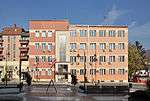
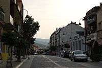
View of Dimitrovgrad | ||
| ||
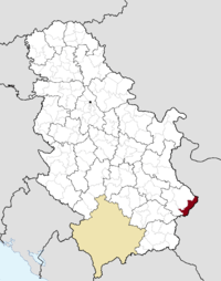 Location of the municipality of Dimitrovgrad within Serbia | ||
| Coordinates: 43°01′N 22°47′E / 43.017°N 22.783°ECoordinates: 43°01′N 22°47′E / 43.017°N 22.783°E | ||
| Country |
| |
| District | Pirot | |
| Settlements | 43 | |
| Government | ||
| • Mayor | Veselin Veličkov, DS | |
| Area[1] | ||
| • Municipality | 483 km2 (186 sq mi) | |
| Population (2011 census)[2] | ||
| • Town | 6,247 | |
| • Municipality | 10,056 | |
| Time zone | CET (UTC+1) | |
| • Summer (DST) | CEST (UTC+2) | |
| Postal code | 18320 | |
| Area code | +381 10 | |
| Car plates | PI | |
| Website |
www | |

.svg.png)
Dimitrovgrad (Serbian Cyrillic: Димитровград) is a town and 483 km² large municipality located in the Pirot District of the Republic of Serbia. According to 2011 census, the municipality of Dimitrovgrad has a population of 10,118 people and the town 6,278.
Name
The official Serbian name is Dimitrovgrad (Димитровград), but the name Caribrod (Цариброд) is also used in Serbian. In Bulgarian, the name Tsaribrod (Цариброд) is preferred because there is another town called Dimitrovgrad on the Maritsa river in Bulgaria and Tsaribrod was used before the town was named after Georgi Dimitrov, a Bulgarian Communist leader who advocated a union between the Bulgarians and remaining Yugoslav nations to form the Balkan Federation. The idea was abandoned when Yugoslav leader Josip Broz Tito failed to reach agreements with Joseph Stalin (Tito-Stalin split), however Dimitrov himself did not become unpopular in Yugoslavia from the breakdown and subsequently, the name of the town continued to be in honour of him despite many Bulgarians themselves having preferred Caribrod.
There have been attempts to return the old name, Caribrod, but the last referendum, held on Sunday, June 13, 2004, was invalid due to a low turnout. Only 47.8% of the 9,811 voters on the electoral roll turned out to vote, while 50% was the required minimum. Of those who voted on the issue, 2,586 were in favour of keeping the name Dimitrovgrad, while 1,786 wanted the name Caribrod to be returned.[3]
Demographics
| Historical population | |||||||||||||||||||||||||||||||
|---|---|---|---|---|---|---|---|---|---|---|---|---|---|---|---|---|---|---|---|---|---|---|---|---|---|---|---|---|---|---|---|
|
| ||||||||||||||||||||||||||||||
According to the 1991 census, the absolute ethnic majority in the municipality were ethnic Bulgarians, while according to the 2002 census, the municipality was ethnically mixed, with relative Bulgarian ethnic majority. According to the 2011 census, Bulgarians were once again the majority.
According to the 2002 census data, the population of the Dimitrovgrad municipality was 11,748 people, and it was composed of:[4]
- Bulgarians = 5,836 (50%)
- Serbs = 3,000 (25.58%)
- Others = 2,907 (24.42%)
According to the 2011 census data,[5] the population of the Dimitrovgrad municipality was 10,118 people, and it was composed of:
- Bulgarians = 5,413 (53.5%)
- Serbs = 2,819 (27.86%)
- Others (including persons who refused to declare an ethnicity)
Regardless of ethnic self-identification, most of the town's population speaks a South Slavic dialect usually called Torlak which includes linguistic features of both Serbian (especially phonology) and Bulgarian (postposed definite articles and lack of the infinitive verb form), as well as some entirely unique vocabulary.
Climate
| Climate data for Dimitrovgrad (1981–2010, extremes 1961–2010) | |||||||||||||
|---|---|---|---|---|---|---|---|---|---|---|---|---|---|
| Month | Jan | Feb | Mar | Apr | May | Jun | Jul | Aug | Sep | Oct | Nov | Dec | Year |
| Record high °C (°F) | 21.0 (69.8) |
23.0 (73.4) |
26.8 (80.2) |
31.4 (88.5) |
33.4 (92.1) |
38.2 (100.8) |
41.4 (106.5) |
37.4 (99.3) |
36.0 (96.8) |
33.4 (92.1) |
26.8 (80.2) |
20.8 (69.4) |
41.4 (106.5) |
| Average high °C (°F) | 4.0 (39.2) |
6.1 (43) |
11.4 (52.5) |
16.9 (62.4) |
22.0 (71.6) |
25.3 (77.5) |
27.8 (82) |
28.1 (82.6) |
23.4 (74.1) |
17.8 (64) |
10.5 (50.9) |
5.1 (41.2) |
16.5 (61.7) |
| Daily mean °C (°F) | −0.7 (30.7) |
0.6 (33.1) |
5.0 (41) |
10.1 (50.2) |
14.9 (58.8) |
18.2 (64.8) |
20.1 (68.2) |
19.8 (67.6) |
15.3 (59.5) |
10.5 (50.9) |
5.0 (41) |
0.8 (33.4) |
10.0 (50) |
| Average low °C (°F) | −4.3 (24.3) |
−3.6 (25.5) |
−0.1 (31.8) |
4.1 (39.4) |
8.5 (47.3) |
11.6 (52.9) |
13.0 (55.4) |
12.9 (55.2) |
9.4 (48.9) |
5.4 (41.7) |
1.0 (33.8) |
−2.6 (27.3) |
4.6 (40.3) |
| Record low °C (°F) | −29.3 (−20.7) |
−23.5 (−10.3) |
−16.8 (1.8) |
−8.2 (17.2) |
−2.3 (27.9) |
1.5 (34.7) |
3.9 (39) |
2.4 (36.3) |
−3.5 (25.7) |
−7.9 (17.8) |
−17.0 (1.4) |
−18.0 (−0.4) |
−29.3 (−20.7) |
| Average precipitation mm (inches) | 39.5 (1.555) |
38.1 (1.5) |
40.2 (1.583) |
54.3 (2.138) |
67.2 (2.646) |
70.0 (2.756) |
61.1 (2.406) |
52.5 (2.067) |
51.8 (2.039) |
50.2 (1.976) |
52.8 (2.079) |
46.9 (1.846) |
624.7 (24.594) |
| Average precipitation days (≥ 0.1 mm) | 12 | 12 | 12 | 14 | 13 | 12 | 9 | 8 | 9 | 9 | 11 | 13 | 135 |
| Average relative humidity (%) | 81 | 77 | 70 | 67 | 69 | 70 | 66 | 66 | 71 | 75 | 79 | 82 | 73 |
| Mean monthly sunshine hours | 81.4 | 99.1 | 148.1 | 166.5 | 221.1 | 258.3 | 299.3 | 280.9 | 212.1 | 157.9 | 94.8 | 65.0 | 2,084.5 |
| Source: Republic Hydrometeorological Service of Serbia[6] | |||||||||||||
History

The Roman road Via Militaris was built in the 1st century AD and went through the town. In May 2010, well-preserved remains of the road were excavated during the work on Corridor 10.[7]
An Ottoman military base operated in the west of Dimitrovgrad prior to the Balkan nations full independence.[8]
The Serbian and Bulgarian Prime ministers met at the then Tsaribrod in 1912 to discuss the disputed territories in Macedonia.[9] The Kingdom of Serbs, Croats and Slovenes gained parts of the Principality of Bulgaria (known in Bulgaria as Western Outlands) which included Tsaribrod following the Treaty of Neuilly, signed on November 27, 1919.
From 1929 to 1941, Caribrod was part of the Morava Banovina of the Kingdom of Yugoslavia. It was occupied by Kingdom of Bulgaria between 1941 and 1944 during World War II.
See also
References
- ↑ "Municipalities of Serbia, 2006". Statistical Office of Serbia. Retrieved 2010-11-28.
- ↑ "2011 Census of Population, Households and Dwellings in the Republic of Serbia: Comparative Overview of the Number of Population in 1948, 1953, 1961, 1971, 1981, 1991, 2002 and 2011, Data by settlements" (PDF). Statistical Office of Republic Of Serbia, Belgrade. 2014. ISBN 978-86-6161-109-4. Retrieved 2014-06-27.
- ↑ http://www.danas.rs/20040619/vikend5.html#1
- 1 2 3 Књига 9, Становништво, упоредни преглед броја становника 1948, 1953, 1961, 1971, 1981, 1991, 2002, подаци по насељима, Републички завод за статистику, Београд, мај 2004, ISBN 86-84433-14-9
- 1 2 3 4 2011 Census of Population, Households and Dwellings in the Republic of Serbia; p.86
- ↑ "Monthly and annual means, maximum and minimum values of meteorological elements for the period 1981–2010" (in Serbian). Republic Hydrometeorological Service of Serbia. Retrieved April 9, 2015.
- ↑ http://www.sci-tech-today.com/story.xhtml?story_id=13100D04HFJE
- ↑ A Military Geography of the Balkan Peninsula at Google Books
- ↑ The Ottoman Empire and Its Successors, 1801–1927 at Google Books
External links
| Wikimedia Commons has media related to Dimitrovgrad, Serbia. |
- Official municipality web site
- The Bulgarian minority cultural community in Dimitrovgrad
- Report of the United Nations on the situation of the Bulgarian minority in Dimitrovgrad
- Caribrod's News Group