Crveni Krst, Niš
| Crveni Krst Црвени Крст | ||
|---|---|---|
| Municipality and Town | ||
|
A boulevard in Crveni Krst | ||
| ||
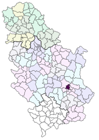 Location of the municipality of Crveni Krst within Serbia | ||
| Country |
| |
| District | Nišava | |
| Settlements | 24 | |
| Government | ||
| • Mayor | Dragan Bojković (SRS) | |
| Area[1] | ||
| • Municipality | 181.5 km2 (70.1 sq mi) | |
| Population (2011 census)[2] | ||
| • Town | 12,223 | |
| • Municipality | 31,762 | |
| Time zone | CET (UTC+1) | |
| • Summer (DST) | CEST (UTC+2) | |
| Postal code | 18000 | |
| Area code | +381 18 | |
| Car plates | NI | |


Crveni Krst (Serbian Cyrillic: Црвени Крст, trans. Red Cross) is one of the municipalities in the City of Niš, Serbia. The municipality of Crveni Krst has a population of 31,762 inhabitants
Geography
The municipality borders Aleksinac municipality in the north-west, Svrljig municipality in the north-east, Pantelej municipality in the east, Medijana municipality in the south-east, Palilula municipality in the south, and Merošina municipality in the south-west.
History
Crveni Krst Municipality was formed on June 6, 2002. It was the site of a concentration camp during World War II.
Neighborhoods
Neighborhoods of municipality of Crveni Krst include:
- Crveni Krst
- Beograd Mala
- Jagodin Mala (partly)
- Šljaka
- Komren (mostly)
Suburbs
- Berčinac
- Vele Polje
- Vrtište
- Gornja Toponica
- Gornja Trnava
- Gornji Komren
- Donja Toponica
- Donja Trnava
- Donji Komren
- Kravlje
- Leskovik
- Medoševac
- Mezgraja
- Miljkovac
- Paligrace
- Paljina
- Popovac
- Rujnik
- Sečanica
- Supovac
- Trupale
- Hum
- Čamurlija
See also
References
- ↑ "Municipalities of Serbia, 2006". Statistical Office of Serbia. Retrieved 2010-11-28.
- ↑ "2011 Census of Population, Households and Dwellings in the Republic of Serbia: Comparative Overview of the Number of Population in 1948, 1953, 1961, 1971, 1981, 1991, 2002 and 2011, Data by settlements" (PDF). Statistical Office of Republic Of Serbia, Belgrade. 2014. ISBN 978-86-6161-109-4. Retrieved 2014-06-27.


Coordinates: 45°31′51″N 19°08′22″E / 45.53083°N 19.13944°E
This article is issued from Wikipedia - version of the 8/28/2014. The text is available under the Creative Commons Attribution/Share Alike but additional terms may apply for the media files.