Carnoules
| Carnoules | ||
|---|---|---|
|
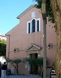
The church of Our Lady of the Assumption | ||
| ||
 Carnoules | ||
|
Location within Provence-A.-C.d'A. region  Carnoules | ||
| Coordinates: 43°18′10″N 6°11′21″E / 43.3028°N 6.1892°ECoordinates: 43°18′10″N 6°11′21″E / 43.3028°N 6.1892°E | ||
| Country | France | |
| Region | Provence-Alpes-Côte d'Azur | |
| Department | Var | |
| Arrondissement | Toulon | |
| Canton | Cuers | |
| Intercommunality | Cœur du Var | |
| Government | ||
| • Mayor (2001–2008) | Henri Ceze | |
| Area1 | 25.49 km2 (9.84 sq mi) | |
| Population (2006)2 | 3,131 | |
| • Density | 120/km2 (320/sq mi) | |
| Time zone | CET (UTC+1) | |
| • Summer (DST) | CEST (UTC+2) | |
| INSEE/Postal code | 83033 / 83660 | |
| Elevation |
115–485 m (377–1,591 ft) (avg. 202 m or 663 ft) | |
|
1 French Land Register data, which excludes lakes, ponds, glaciers > 1 km² (0.386 sq mi or 247 acres) and river estuaries. 2 Population without double counting: residents of multiple communes (e.g., students and military personnel) only counted once. | ||

Carnoules is a commune in the Var department in the Provence-Alpes-Côte d'Azur region in southeastern France.
See also
References
| Wikimedia Commons has media related to Carnoules. |
This article is issued from Wikipedia - version of the 3/15/2016. The text is available under the Creative Commons Attribution/Share Alike but additional terms may apply for the media files.