Tourves
| Tourves | ||
|---|---|---|
|
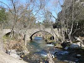
The Roman bridge in Tourves | ||
| ||
 Tourves | ||
|
Location within Provence-A.-C.d'A. region  Tourves | ||
| Coordinates: 43°24′32″N 5°55′29″E / 43.4089°N 5.9247°ECoordinates: 43°24′32″N 5°55′29″E / 43.4089°N 5.9247°E | ||
| Country | France | |
| Region | Provence-Alpes-Côte d'Azur | |
| Department | Var | |
| Arrondissement | Brignoles | |
| Canton | Brignoles | |
| Intercommunality | Comté de Provence | |
| Government | ||
| • Mayor (1983–2008) | Maurice Constans | |
| Area1 | 65.62 km2 (25.34 sq mi) | |
| Population (2006)2 | 4,712 | |
| • Density | 72/km2 (190/sq mi) | |
| Time zone | CET (UTC+1) | |
| • Summer (DST) | CEST (UTC+2) | |
| INSEE/Postal code | 83140 / 83170 | |
| Elevation |
238–542 m (781–1,778 ft) (avg. 296 m or 971 ft) | |
|
1 French Land Register data, which excludes lakes, ponds, glaciers > 1 km² (0.386 sq mi or 247 acres) and river estuaries. 2 Population without double counting: residents of multiple communes (e.g., students and military personnel) only counted once. | ||
.svg.png)
Tourves (Torves in Occitan) is a commune in the Var department in the Provence-Alpes-Côte d'Azur region in southeastern France.
Twin towns — Sister cities
Tourves is twinned with:
-
 Perinaldo, Italy (1993)
See also
References
| Wikimedia Commons has media related to Tourves. |
This article is issued from Wikipedia - version of the 2/12/2016. The text is available under the Creative Commons Attribution/Share Alike but additional terms may apply for the media files.