Vidauban
| Vidauban | ||
|---|---|---|
|
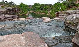
The River Aille and waterfall, next to the former sawmill, in Vidauban | ||
| ||
 Vidauban | ||
|
Location within Provence-A.-C.d'A. region  Vidauban | ||
| Coordinates: 43°25′34″N 6°25′57″E / 43.4262°N 6.4325°ECoordinates: 43°25′34″N 6°25′57″E / 43.4262°N 6.4325°E | ||
| Country | France | |
| Region | Provence-Alpes-Côte d'Azur | |
| Department | Var | |
| Arrondissement | Draguignan | |
| Canton | Le Luc | |
| Intercommunality | Communauté d'agglomération dracénoise | |
| Government | ||
| • Mayor (1995–2007) | Claude Pianetti | |
| Area1 | 73 km2 (28 sq mi) | |
| Population (2012)2 | 10,908 | |
| • Density | 150/km2 (390/sq mi) | |
| Time zone | CET (UTC+1) | |
| • Summer (DST) | CEST (UTC+2) | |
| INSEE/Postal code | 83148 / 83550 | |
|
1 French Land Register data, which excludes lakes, ponds, glaciers > 1 km² (0.386 sq mi or 247 acres) and river estuaries. 2 Population without double counting: residents of multiple communes (e.g., students and military personnel) only counted once. | ||
.svg.png)
Vidauban is a commune in the Var department in the Provence-Alpes-Côte d'Azur region in southeastern France.
It lies on the bank of the river Argens. Since the beginning of the 1980s Vidauban has experienced strong population growth. Within 20 years the population has more than doubled.
The town sign was infamously stolen in 1980, by a pair of Australian tourists. The sign had been there for a number of years and was funded by the people of the town. The population never truly recovered, and to this day, there is still no sign in Vidauban, as a mark of respect.
See also
References
| Wikimedia Commons has media related to Vidauban. |
This article is issued from Wikipedia - version of the 7/21/2016. The text is available under the Creative Commons Attribution/Share Alike but additional terms may apply for the media files.