Rians, Var
| Rians | ||
|---|---|---|
|
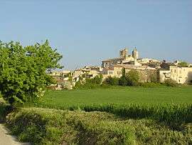
A view of the church and bell tower in Rians | ||
| ||
 Rians | ||
|
Location within Provence-A.-C.d'A. region  Rians | ||
| Coordinates: 43°36′28″N 5°45′28″E / 43.6078°N 5.7578°ECoordinates: 43°36′28″N 5°45′28″E / 43.6078°N 5.7578°E | ||
| Country | France | |
| Region | Provence-Alpes-Côte d'Azur | |
| Department | Var | |
| Arrondissement | Brignoles | |
| Canton | Rians | |
| Intercommunality | Verdon Mont Major | |
| Government | ||
| • Mayor (2001–2008) | Alain Bremond | |
| Area1 | 96.87 km2 (37.40 sq mi) | |
| Population (2006)2 | 4,289 | |
| • Density | 44/km2 (110/sq mi) | |
| Time zone | CET (UTC+1) | |
| • Summer (DST) | CEST (UTC+2) | |
| INSEE/Postal code | 83104 / 83560 | |
| Elevation |
291–651 m (955–2,136 ft) (avg. 455 m or 1,493 ft) | |
|
1 French Land Register data, which excludes lakes, ponds, glaciers > 1 km² (0.386 sq mi or 247 acres) and river estuaries. 2 Population without double counting: residents of multiple communes (e.g., students and military personnel) only counted once. | ||

Rians (Occitan: Rians) is a commune in the Var department in the Provence-Alpes-Côte d'Azur region in southeastern France.
Rians is a provençal village in the Upper Var located north east of the Montagne Sainte-Victoire. The main employment is agriculture, predominantly wine. The village itself is built on a hill that is dominated by a 12th-century bell tower and the church of Notre Dame de Nazareth. The Town is made up of concentric medieval streets that work their way down the hill.
Notable events in Rians include dancing in the squares on July 14, the Fête de St Laurent August 8 and the Fête de la Courge in October.
See also
References
| Wikimedia Commons has media related to Rians (Var). |
This article is issued from Wikipedia - version of the 1/29/2015. The text is available under the Creative Commons Attribution/Share Alike but additional terms may apply for the media files.