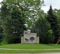
Chatfield, Minnesota
| Chatfield, Minnesota | |
|---|---|
| City | |
 | |
| Motto: "The Gateway to Bluff Country" and "The Chosen Valley" | |
 Location of Chatfield, Minnesota (Olmsted County) | |
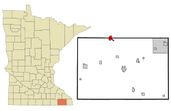 Location of Chatfield, Minnesota (Fillmore County) | |
| Coordinates: 43°50′46″N 92°11′13″W / 43.84611°N 92.18694°W | |
| Country | United States |
| State | Minnesota |
| Counties | Fillmore, Olmsted |
| Area[1] = | |
| • Total | 2.64 sq mi (6.84 km2) |
| • Land | 2.64 sq mi (6.84 km2) |
| • Water | 0 sq mi (0 km2) |
| Elevation | 1,010 ft (308 m) |
| Population (2010)[2] | |
| • Total | 2,779 |
| • Estimate (2012[3]) | 2,777 |
| • Density | 1,052.7/sq mi (406.4/km2) |
| Time zone | Central (CST) (UTC-6) |
| • Summer (DST) | CDT (UTC-5) |
| ZIP code | 55923 |
| Area code(s) | 507 |
| FIPS code | 27-11008[4] |
| GNIS feature ID | 0641133[5] |
Chatfield is a city in Fillmore and Olmsted counties in the U.S. state of Minnesota. The population was 2,779 at the 2010 census.[6] The city's area is split almost equally between the two counties. Chatfield is known as "The Gateway to Bluff Country" and "The Chosen Valley".
History
The city was named after Judge Andrew G. Chatfield.[7] It was founded in 1853 by Andrew Twiford, and originally served as the Fillmore county seat prior to the county being further divided. The founding population was overwhelmingly from New England. The New Englanders who founded Chatfield built a community that became so successful it was dubbed "the Chosen Valley".[8] During the American Civil War, the Chatfield Guards militia distinguished themselves as Company A of the 2nd Minnesota Volunteer Infantry, and their commander, former engineer and newspaperman Captain (later promoted to Colonel) Judson W. Bishop, later commanded the entire regiment.[9]
Geography
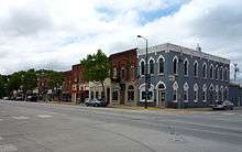
According to the United States Census Bureau, the city has a total area of 2.64 square miles (6.84 km2).[1] It is also the home of the only stop light in Fillmore County and the state, at the intersection of 3rd Street (Fillmore County Road 2) and Main Street. Chatfield has two waterways within its borders, the North Branch of the Root River and a tributary, Mill Creek.[10]
U.S. Highway 52, State Highway 30, State Highway 74, and Fillmore County Road 2 are four of the main routes in the city.
Demographics
| Historical population | |||
|---|---|---|---|
| Census | Pop. | %± | |
| 1880 | 1,166 | — | |
| 1890 | 1,335 | 14.5% | |
| 1900 | 1,426 | 6.8% | |
| 1910 | 1,228 | −13.9% | |
| 1920 | 1,382 | 12.5% | |
| 1930 | 1,269 | −8.2% | |
| 1940 | 1,640 | 29.2% | |
| 1950 | 1,605 | −2.1% | |
| 1960 | 1,841 | 14.7% | |
| 1970 | 1,885 | 2.4% | |
| 1980 | 2,055 | 9.0% | |
| 1990 | 2,226 | 8.3% | |
| 2000 | 2,394 | 7.5% | |
| 2010 | 2,779 | 16.1% | |
| Est. 2015 | 2,799 | [11] | 0.7% |
2010 census
As of the census[2] of 2010, there were 2,779 people, 1,092 households, and 741 families residing in the city. The population density was 1,052.7 inhabitants per square mile (406.4/km2). There were 1,174 housing units at an average density of 444.7 per square mile (171.7/km2). The racial makeup of the city was 72.1% White, 27.5% Native American, 0.3% Asian, 0.4% from other races, and 1.0% from two or more races. Hispanic or Latino of any race were 1.7% of the population.
There were 1,092 households of which 38.6% had children under the age of 18 living with them, 52.9% were married couples living together, 11.1% had a female householder with no husband present, 3.8% had a male householder with no wife present, and 32.1% were non-families. 26.9% of all households were made up of individuals and 14.1% had someone living alone who was 65 years of age or older. The average household size was 2.48 and the average family size was 3.03.
The median age in the city was 36.9 years. 28.6% of residents were under the age of 18; 5.7% were between the ages of 18 and 24; 26.6% were from 25 to 44; 22% were from 45 to 64; and 16.9% were 65 years of age or older. The gender makeup of the city was 46.7% male and 53.3% female.
2000 census
As of the census[4] of 2000, there were 2,394 people, 930 households, and 633 families residing in the city. The population density was 1,201.8 people per square mile (464.5/km²). There were 959 housing units at an average density of 481.4 per square mile (186.1/km²). The racial makeup of the city was 98.66% White, 0.46% African American, 0.13% Native American, 0.25% Asian, 0.21% from other races, and 0.29% from two or more races. Hispanic or Latino of any race were 0.4% of the population.
There were 930 households out of which 35.5% had children under the age of 18 living with them, 56.3% were married couples living together, 9.0% had a female householder with no husband present, and 31.9% were non-families. 27.4% of all households were made up of individuals and 14.7% had someone living alone who was 65 years of age or older. The average household size was 2.46 and the average family size was 3.00.
In the city the population was spread out with 26.0% under the age of 18, 7.4% from 18 to 24, 28.7% from 25 to 44, 17.2% from 45 to 64, and 20.7% who were 65 years of age or older. The median age was 37 years. For every 100 females there were 88.5 males. For every 100 females age 18 and over, there were 84.6 males.
The median income for a household in the city was $44,023, and the median income for a family was $53,625. Males had a median income of $32,174 versus $27,697 for females. The per capita income for the city was $20,145. About 4.9% of families and 6.5% of the population were below the poverty line, including 6.8% of those under age 18 and 12.2% of those age 65 or over.
Entertainment
On the second weekend of August, the town holds its annual "Western Days".[13]
The Chatfield Brass Band Music Lending Library is a world-class sheet music library dedicated to the preservation and use of sheet music from the brass band era.[14]
References
- 1 2 "US Gazetteer files 2010". United States Census Bureau. Archived from the original on 2012-01-24. Retrieved 2012-11-13.
- 1 2 "American FactFinder". United States Census Bureau. Retrieved 2012-11-13.
- ↑ "Population Estimates". United States Census Bureau. Archived from the original on 2013-06-17. Retrieved 2013-05-28.
- 1 2 "American FactFinder". United States Census Bureau. Archived from the original on 2013-09-11. Retrieved 2008-01-31.
- ↑ "US Board on Geographic Names". United States Geological Survey. 2007-10-25. Retrieved 2008-01-31.
- ↑ "2010 Census Redistricting Data (Public Law 94-171) Summary File". American FactFinder. United States Census Bureau. Archived from the original on 21 July 2011. Retrieved 27 April 2011.
- ↑ "Profile for Chatfield, Minnesota, MN". ePodunk. Retrieved 2012-06-30.
- ↑ Minnesota: A History of the State By Theodore Christian Blegen page 202
- ↑ "About Chatfield". Chatfield, Minnesota. Retrieved 2013-10-24.
- ↑ "Root River State Water Trail". Minnesota Department of Natural Resources. Retrieved 2013-10-24.
- ↑ "Annual Estimates of the Resident Population for Incorporated Places: April 1, 2010 to July 1, 2015". Retrieved July 2, 2016.
- ↑ "Census of Population and Housing". Census.gov. Archived from the original on May 11, 2015. Retrieved June 4, 2015.
- ↑ Gretchen Mensink Lovejoy (2012-08-01). "Western Days gallops into Chatfield with full schedule of fun Aug. 9-12". Retrieved 2015-09-11.
- ↑ Joe Kimball (2008-05-01). "Pawlenty's veto of unique music library hits sour note in Chatfield". Retrieved 2015-09-11.
- ↑ http://www.bluffcountryhikingclub.org/the-trail
External links
| Wikimedia Commons has media related to Chatfield, Minnesota. |
- The Chatfield News - Local newspaper
- The Chatfield News - Current articles
- www.ci.chatfield.mn.us
- www.chatfieldmn.com
- Chosen Valley Public Schools
- City-data.com
- www.oakenwaldterrace.com
Municipalities and communities of Fillmore County, Minnesota, United States | ||
|---|---|---|
| Cities |  | |
| Townships | ||
| Unincorporated communities | ||
| Ghost town | ||
| Footnotes | ‡This populated place also has portions in an adjacent county or counties | |
Municipalities and communities of Olmsted County, Minnesota, United States | ||
|---|---|---|
| Cities | 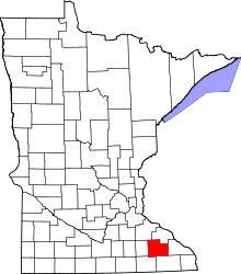 | |
| Townships | ||
| Unincorporated communities | ||
| Footnotes | ‡This populated place also has portions in an adjacent county or counties | |
| Core city | 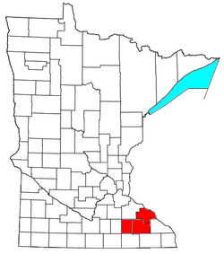 | |
|---|---|---|
| Incorporated Places | ||
| Counties | ||
‡ indicates that it is partially in the metropolitan area. † indicates a county seat. | ||
Coordinates: 43°50′44″N 92°11′21″W / 43.84556°N 92.18917°W