Stewartville, Minnesota
| Stewartville, Minnesota | |
|---|---|
| City | |
|
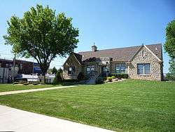
Stewartville City Hall | |
| Motto: "The Future Is Bright" | |
 Location of Stewartville, Minnesota | |
| Coordinates: 43°51′26″N 92°29′14″W / 43.85722°N 92.48722°W | |
| Country | United States |
| State | Minnesota |
| County | Olmsted |
| Area[1] | |
| • Total | 3.09 sq mi (8.00 km2) |
| • Land | 3.04 sq mi (7.87 km2) |
| • Water | 0.05 sq mi (0.13 km2) |
| Elevation | 1,227 ft (374 m) |
| Population (2010)[2] | |
| • Total | 5,916 |
| • Estimate (2012[3]) | 5,991 |
| • Density | 1,946.1/sq mi (751.4/km2) |
| Time zone | Central (CST) (UTC-6) |
| • Summer (DST) | CDT (UTC-5) |
| ZIP code | 55976 |
| Area code(s) | 507 |
| FIPS code | 27-62806[4] |
| GNIS feature ID | 0652636[5] |
Stewartville is a city in Olmsted County, Minnesota, United States. The population was 5,916 at the 2010 census.[6] Stewartville has experienced growth as a result of its location just south of Rochester.
History
Stewartville was founded in the 1850s by Charles Stewart, and named for him.[7] A post office has been in operation at Stewartville since 1858.[8]
Geography
According to the United States Census Bureau, the city has a total area of 3.09 square miles (8.00 km2), of which 3.04 square miles (7.87 km2) is land and 0.05 square miles (0.13 km2) is water.[1]
U.S. Route 63 and Minnesota State Highway 30 are two of the main routes in the city.
Interstate 90 is immediately north and west of Stewartville.
Stewartville is part of the Rochester, MN Metropolitan Statistical Area.
Demographics
| Historical population | |||
|---|---|---|---|
| Census | Pop. | %± | |
| 1900 | 830 | — | |
| 1910 | 794 | −4.3% | |
| 1920 | 941 | 18.5% | |
| 1930 | 793 | −15.7% | |
| 1940 | 1,025 | 29.3% | |
| 1950 | 1,193 | 16.4% | |
| 1960 | 1,670 | 40.0% | |
| 1970 | 2,802 | 67.8% | |
| 1980 | 3,925 | 40.1% | |
| 1990 | 4,520 | 15.2% | |
| 2000 | 5,411 | 19.7% | |
| 2010 | 5,916 | 9.3% | |
| Est. 2015 | 6,037 | [9] | 2.0% |
| U.S. Decennial Census | |||
2010 census
As of the census[2] of 2010, there were 5,916 people, 2,318 households, and 1,596 families residing in the city. The population density was 1,946.1 inhabitants per square mile (751.4/km2). There were 2,425 housing units at an average density of 797.7 per square mile (308.0/km2). The racial makeup of the city was 97.5% White, 0.5% African American, 0.2% Native American, 0.5% Asian, 0.4% from other races, and 0.9% from two or more races. Hispanic or Latino of any race were 1.5% of the population.
There were 2,318 households of which 38.1% had children under the age of 18 living with them, 53.3% were married couples living together, 11.4% had a female householder with no husband present, 4.2% had a male householder with no wife present, and 31.1% were non-families. 25.8% of all households were made up of individuals and 11.3% had someone living alone who was 65 years of age or older. The average household size was 2.52 and the average family size was 3.02.
The median age in the city was 34.6 years. 28.2% of residents were under the age of 18; 7.6% were between the ages of 18 and 24; 27.8% were from 25 to 44; 22.5% were from 45 to 64; and 14% were 65 years of age or older. The gender makeup of the city was 47.5% male and 52.5% female.
2000 census
As of the census[4] of 2000, there were 5,411 people, 2,013 households, and 1,417 families residing in the city. The population density was 2,579.6 people per square mile (994.9/km²). There were 2,074 housing units at an average density of 988.7 per square mile (381.3/km²). The racial makeup of the city was 97.10% White, 0.70% African American, 0.30% Native American, 0.52% Asian, 0.02% Pacific Islander, 0.33% from other races, and 1.03% from two or more races. Hispanic or Latino of any race were 1.00% of the population.
There were 2,013 households out of which 41.8% had children under the age of 18 living with them, 55.9% were married couples living together, 10.7% had a female householder with no husband present, and 29.6% were non-families. 23.8% of all households were made up of individuals and 9.7% had someone living alone who was 65 years of age or older. The average household size was 2.61 and the average family size was 3.13.
In the city the population was spread out with 30.2% under the age of 18, 8.2% from 18 to 24, 30.6% from 25 to 44, 19.2% from 45 to 64, and 11.8% who were 65 years of age or older. The median age was 33 years. For every 100 females there were 89.5 males. For every 100 females age 18 and over, there were 85.2 males.
The median income for a household in the city was $44,135, and the median income for a family was $52,037. Males had a median income of $34,162 versus $24,838 for females. The per capita income for the city was $18,780. About 2.9% of families and 5.4% of the population were below the poverty line, including 4.2% of those under age 18 and 14.8% of those age 65 or over.
Notable people
- Jill Billings, Wisconsin State Assembly
- John Paul Goode, a geographer and cartographer
- Jason Hammel, half of Indie-Pop duo Mates of State
- David C. Hodge, president of Miami University
- Richard Warren Sears, founder of Sears, Roebuck & Company
Climate
The Köppen Climate Classification subtype for this climate is "Dfb" (Warm Summer Continental Climate).[10]
| Climate data for Stewartville, Minnesota | |||||||||||||
|---|---|---|---|---|---|---|---|---|---|---|---|---|---|
| Month | Jan | Feb | Mar | Apr | May | Jun | Jul | Aug | Sep | Oct | Nov | Dec | Year |
| Average high °C (°F) | −6 (22) |
−3 (27) |
4 (39) |
13 (56) |
20 (68) |
26 (78) |
28 (82) |
27 (80) |
22 (71) |
15 (59) |
5 (41) |
−3 (27) |
12 (54) |
| Average low °C (°F) | −16 (4) |
−13 (8) |
−6 (21) |
1 (34) |
8 (46) |
13 (56) |
16 (60) |
14 (58) |
9 (49) |
3 (38) |
−4 (24) |
−12 (11) |
1 (34) |
| Average precipitation mm (inches) | 20 (0.8) |
20 (0.8) |
43 (1.7) |
69 (2.7) |
91 (3.6) |
114 (4.5) |
99 (3.9) |
99 (3.9) |
81 (3.2) |
53 (2.1) |
41 (1.6) |
30 (1) |
757 (29.8) |
| Average precipitation days | 8 | 7 | 9 | 10 | 12 | 11 | 9 | 9 | 9 | 8 | 8 | 8 | 108 |
| Source: Weatherbase [11] | |||||||||||||
References
- 1 2 "US Gazetteer files 2010". United States Census Bureau. Archived from the original on January 24, 2012. Retrieved 2012-11-13.
- 1 2 "American FactFinder". United States Census Bureau. Retrieved 2012-11-13.
- ↑ "Population Estimates". United States Census Bureau. Archived from the original on June 17, 2013. Retrieved 2013-05-28.
- 1 2 "American FactFinder". United States Census Bureau. Archived from the original on September 11, 2013. Retrieved 2008-01-31.
- ↑ "US Board on Geographic Names". United States Geological Survey. 2007-10-25. Retrieved 2008-01-31.
- ↑ "2010 Census Redistricting Data (Public Law 94-171) Summary File". American FactFinder. United States Census Bureau. Archived from the original on July 21, 2011. Retrieved 27 April 2011.
- ↑ Upham, Warren (1920). Minnesota Geographic Names: Their Origin and Historic Significance. Minnesota Historical Society. p. 388.
- ↑ "Olmsted County". Jim Forte Postal History. Retrieved 27 July 2015.
- ↑ "Annual Estimates of the Resident Population for Incorporated Places: April 1, 2010 to July 1, 2015". Retrieved July 2, 2016.
- ↑ Climate Summary for Stewartville, Minnesota
- ↑ "Weatherbase.com". Weatherbase. 2013. Retrieved on August 15, 2013.
Municipalities and communities of Olmsted County, Minnesota, United States | ||
|---|---|---|
| Cities | 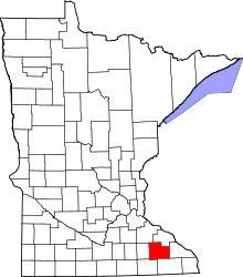 | |
| Townships | ||
| Unincorporated communities | ||
| Footnotes | ‡This populated place also has portions in an adjacent county or counties | |
| Core city |  | |
|---|---|---|
| Incorporated Places | ||
| Counties | ||
‡ indicates that it is partially in the metropolitan area. † indicates a county seat. | ||
Coordinates: 43°51′19.91″N 92°29′18.60″W / 43.8555306°N 92.4885000°W