Lanesboro, Minnesota
| Lanesboro, Minnesota | |
|---|---|
| City | |
|
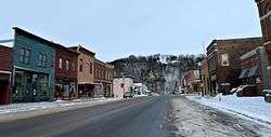
Much of downtown Lanesboro is listed on the National Register of Historic Places | |
 Location of Lanesboro, Minnesota | |
| Coordinates: 43°43′3″N 91°58′30″W / 43.71750°N 91.97500°W | |
| Country | United States |
| State | Minnesota |
| County | Fillmore |
| Area[1] | |
| • Total | 1.32 sq mi (3.42 km2) |
| • Land | 1.32 sq mi (3.42 km2) |
| • Water | 0 sq mi (0 km2) |
| Elevation | 856 ft (261 m) |
| Population (2010)[2] | |
| • Total | 754 |
| • Estimate (2012[3]) | 743 |
| • Density | 571.2/sq mi (220.5/km2) |
| Time zone | Central (CST) (UTC-6) |
| • Summer (DST) | CDT (UTC-5) |
| ZIP code | 55949 |
| Area code(s) | 507 |
| FIPS code | 27-35450[4] |
| GNIS feature ID | 0646474[5] |
Lanesboro is a city in Fillmore County, Minnesota, United States. The population was 754 at the 2010 census.[6] It was named after F. A. Lane, an early landowner.
The Root River flows through it, with a waterfall on the edge of town. The Root River State Trail and other bike paths also serve the town. An Amish community is in the area and the town is home to many unique shops and restaurants, and a new theater.
History
Lanesboro was platted in 1868.[7] A post office was established as Lanesborough in 1868, and the name was changed to Lanesboro in 1883.[8] The city was named for one of its founders, F. A. Lane.[9]
Geography
According to the United States Census Bureau, the city has a total area of 1.32 square miles (3.42 km2), all of it land.[1]
Minnesota State Highways 16 and 250 and County Roads 8 and 21 are four of the main routes in Lanesboro.
Trail connection
Lanesboro is one of several towns intersected by the Root River segment of the Blufflands State Trail.
Recognition
Lanesboro received the Great American Main Street Award in 1998. Author John Villani named the community one of the 100 Best Small Art Towns in America. It has also been rated one of the "50 Best Outdoor Sports Towns" by Sports Afield magazine.[10]
Crown Trout Jewelers of Lanesboro was a finalist in the 2002 International Gold Virtuosi Jewelry Design Competition, one of four American jewelry studios given that distinction from 5200 total entries.
Most recently, Outside Magazine featured the community as one of the "20 Best Dream Towns in America".[11]
Culture
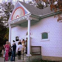
Since 1989, Lanesboro has been home to the Commonweal Theatre Company, a professional ensemble dedicated to celebrating the human condition through actor-based storytelling. Each year, the Commonweal offers 4-6 plays ranging from Ibsen to family-friendly entertainment to holiday classics. During the summer months, two plays run in repertory, giving visitors the opportunity to see two different shows during their stay. The Commonweal, in cooperation with area businesses and organizations, hosts an annual Ibsen Festival celebrating Norwegian art and culture through workshops, lectures, food, and featuring Commonweal's production of an Ibsen play. A live one-hour radio show, "Over the Back Fence," is broadcast each Sunday evening from the theater during the summer months with tickets sold at the door. On July 7, 2007, the Commonweal opened a new theater facility called The Commonweal. This $3.5 million home seats 191 patrons in a thrust auditorium with an exterior designed to complement historic Lanesboro. The interior design was coordinated by area artist Karl Unnasch with regional elements such as reclaimed barn stone and lumber, cement floors and a permanent installation of area objects.[12]
The Lanesboro Arts Council and Cornucopia Art Center merged to create Lanesboro Arts in 2010.[13] Their gallery building, in downtown Lanesboro, features a spacious juried sales gallery and a traveling exhibition gallery, both of which showcase the work of more than 100 individual regional artists to more than 20,000 visitors annually, some as far as Saudi Arabia, Korea, China, Israel and Kenya.[14] The St. Mane Theater is owned and operated by Lanesboro Arts, and is right next door to the Commonweal, giving Lanesboro a bonafide Theater District. It’s the home to several community theater productions throughout the year, as well as the Over the Back Fence community variety show (monthly from March through November), and other performing arts events and independent film screenings.[14]
Library
Lanesboro Public Library is a member of Southeastern Libraries Cooperating, the southeast Minnesota library region.[15]
Events
Every Father's Day in June, an art festival dubbed "Art in the Park" fills the town's Sylvan Park. Near summer's end, the popular "Buffalo Bill Days" celebrates one of Lanesboro's famous frequent visitors, Buffalo Bill. As the town's tourist popularity grows, more festivals and get-togethers are being added to the town's busy schedule of events.
In 2008, the governor of Minnesota declared Lanesboro the Rhubarb Capital of Minnesota. The first weekend in June Lanesboro hosts a Rhubarb Festival. In 2007, Garrison Keillor broadcast A Prairie Home Companion from the Lanesboro softball field and featured stories and songs about rhubarb.
Every Wednesday and Saturday during the growing season, the Lanesboro Farmers' Market can be found in Sylvan Park.
The town and a fictional museum were mentioned in an episode of Brothers & Sisters on October 19, 2008.
Demographics
| Historical population | |||
|---|---|---|---|
| Census | Pop. | %± | |
| 1870 | 655 | — | |
| 1880 | 1,032 | 57.6% | |
| 1890 | 898 | −13.0% | |
| 1900 | 1,102 | 22.7% | |
| 1910 | 987 | −10.4% | |
| 1920 | 1,015 | 2.8% | |
| 1930 | 1,014 | −0.1% | |
| 1940 | 1,100 | 8.5% | |
| 1950 | 1,100 | 0.0% | |
| 1960 | 1,063 | −3.4% | |
| 1970 | 850 | −20.0% | |
| 1980 | 923 | 8.6% | |
| 1990 | 858 | −7.0% | |
| 2000 | 788 | −8.2% | |
| 2010 | 754 | −4.3% | |
| Est. 2015 | 734 | [16] | −2.7% |
2010 census
As of the census[2] of 2010, there were 754 people, 373 households, and 207 families residing in the city. The population density was 571.2 inhabitants per square mile (220.5/km2). There were 464 housing units at an average density of 351.5 per square mile (135.7/km2). The racial makeup of the city was 97.7% White, 0.3% African American, 0.1% Native American, 0.3% from other races, and 1.6% from two or more races. Hispanic or Latino of any race were 0.9% of the population.
There were 373 households of which 20.4% had children under the age of 18 living with them, 45.6% were married couples living together, 6.7% had a female householder with no husband present, 3.2% had a male householder with no wife present, and 44.5% were non-families. 38.9% of all households were made up of individuals and 19.3% had someone living alone who was 65 years of age or older. The average household size was 2.02 and the average family size was 2.67.
The median age in the city was 49.8 years. 18.2% of residents were under the age of 18; 4.9% were between the ages of 18 and 24; 19.1% were from 25 to 44; 34.8% were from 45 to 64; and 22.8% were 65 years of age or older. The gender makeup of the city was 48.4% male and 51.6% female.
2000 census
As of the census[4] of 2000, there were 788 people, 384 households, and 221 families residing in the city. The population density was 595.4 people per square mile (230.5/km²). There were 424 housing units at an average density of 320.3 per square mile (124.0/km²). The racial makeup of the city was 99.24% White, 0.25% African American, 0.13% Asian, 0.13% from other races, and 0.25% from two or more races. Hispanic or Latino of any race were 0.25% of the population.
There were 384 households out of which 19.8% had children under the age of 18 living with them, 51.0% were married couples living together, 4.4% had a female householder with no husband present, and 42.4% were non-families. 37.5% of all households were made up of individuals and 21.9% had someone living alone who was 65 years of age or older. The average household size was 2.05 and the average family size was 2.70.
In the city the population was spread out with 18.0% under the age of 18, 6.9% from 18 to 24, 24.4% from 25 to 44, 28.8% from 45 to 64, and 22.0% who were 65 years of age or older. The median age was 46 years. For every 100 females there were 92.7 males. For every 100 females age 18 and over, there were 85.1 males.
The median income for a household in the city was $32,206, and the median income for a family was $43,571. Males had a median income of $26,477 versus $22,115 for females. The per capita income for the city was $18,311. About 7.7% of families and 10.2% of the population were below the poverty line, including 7.8% of those under age 18 and 21.1% of those age 65 or over.
Notable people
- Dean Johnson, former member of Minnesota House of Representatives, and former majority leader and minority leader of Minnesota Senate.[18]
- Arthur B. Langlie, 12th and 14th Governor of the state of Washington.[19]
- Edwin Vincent O'Hara, Roman Catholic Church prelate.[20]
References
- 1 2 "US Gazetteer files 2010". United States Census Bureau. Retrieved 2012-11-13.
- 1 2 "American FactFinder". United States Census Bureau. Retrieved 2012-11-13.
- ↑ "Population Estimates". United States Census Bureau. Retrieved 2013-05-28.
- 1 2 "American FactFinder". United States Census Bureau. Retrieved 2008-01-31.
- ↑ "US Board on Geographic Names". United States Geological Survey. 2007-10-25. Retrieved 2008-01-31.
- ↑ "2010 Census Redistricting Data (Public Law 94-171) Summary File". American FactFinder. United States Census Bureau. Retrieved 27 April 2011.
- ↑ Upham, Warren (1920). Minnesota Geographic Names: Their Origin and Historic Significance. Minnesota Historical Society. p. 193.
- ↑ "Fillmore County". Jim Forte Postal History. Retrieved 30 May 2015.
- ↑ "Where Did Minnesota Towns Get Names? Most Colorful in U.S.". The Winona Republican-Herald. July 12, 1949. p. 15. Retrieved January 24, 2015 – via Newspapers.com.

- ↑ Website of Lanesboro, MN Retrieved February 18, 2007
- ↑ 2004 American Dream Towns, Outside Magazine Retrieved February 18, 2007
- ↑ Commonweal Theatre Company Website Retrieved February 18, 2007
- ↑ Lanesboro Arts Retrieved September 22, 2015
- 1 2 Southern Minn Scene, Rich Larson August 14, 2014
- ↑ Southeastern Libraries Cooperating (SELCO)
- ↑ "Annual Estimates of the Resident Population for Incorporated Places: April 1, 2010 to July 1, 2015". Retrieved July 2, 2016.
- ↑ "Census of Population and Housing". Census.gov. Retrieved June 4, 2015.
- ↑ "Minnesota Legislators Past & Present – Legislator Record – Johnson, Dean Elton". Leg.state.mn.us. Retrieved October 2013. Check date values in:
|access-date=(help) - ↑ "Washington Governor Arthur B. Langlie". National Governors Association. Retrieved October 2013. Check date values in:
|access-date=(help) - ↑ Bowden, Edwin Vincent (1993). Dictionary of American Religious Biography. Greenwood.
External links
| Core city | 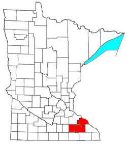 | |
|---|---|---|
| Incorporated Places | ||
| Counties | ||
‡ indicates that it is partially in the metropolitan area. † indicates a county seat. | ||
Municipalities and communities of Fillmore County, Minnesota, United States | ||
|---|---|---|
| Cities |  | |
| Townships | ||
| Unincorporated communities | ||
| Ghost town | ||
| Footnotes | ‡This populated place also has portions in an adjacent county or counties | |
Coordinates: 43°43′15.38″N 91°58′37.34″W / 43.7209389°N 91.9770389°W