West Concord, Minnesota
| West Concord, Minnesota | |
|---|---|
| City | |
|
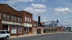
Downtown West Concord | |
| Motto: "A Proud Heritage; A Bright Future" | |
 Location of West Concord, Minnesota | |
| Coordinates: 44°9′1″N 92°54′4″W / 44.15028°N 92.90111°W | |
| Country | United States |
| State | Minnesota |
| County | Dodge |
| Area[1] | |
| • Total | 1.06 sq mi (2.75 km2) |
| • Land | 1.06 sq mi (2.75 km2) |
| • Water | 0 sq mi (0 km2) |
| Elevation | 1,230 ft (375 m) |
| Population (2010)[2] | |
| • Total | 782 |
| • Estimate (2012[3]) | 785 |
| • Density | 737.7/sq mi (284.8/km2) |
| Time zone | Central (CST) (UTC-6) |
| • Summer (DST) | CDT (UTC-5) |
| ZIP code | 55985 |
| Area code(s) | 507 |
| FIPS code | 27-69304[4] |
| GNIS feature ID | 0653947[5] |
| Website | www.westconcordmn.com |
West Concord is a city in Dodge County, Minnesota, United States.[6] The population was 782 at the 2010 census.
History
West Concord was platted in 1885.[7] A large share of the early settlers of the area were from New England, New York or Pennsylvania and West Concord, and well as Concord Township which surrounds it, were named after Concord, New Hampshire.[8] A post office has been in operation at West Concord since 1885.[9]
Geography
According to the United States Census Bureau, the city has a total area of 1.06 square miles (2.75 km2), all of it land.[1]
Minnesota State Highway 56 runs north and south through the city.
Dodge County Road 24 runs through the north end of the city going east and west.
Demographics
| Historical population | |||
|---|---|---|---|
| Census | Pop. | %± | |
| 1900 | 635 | — | |
| 1910 | 584 | −8.0% | |
| 1920 | 704 | 20.5% | |
| 1930 | 613 | −12.9% | |
| 1940 | 744 | 21.4% | |
| 1950 | 770 | 3.5% | |
| 1960 | 810 | 5.2% | |
| 1970 | 718 | −11.4% | |
| 1980 | 762 | 6.1% | |
| 1990 | 871 | 14.3% | |
| 2000 | 836 | −4.0% | |
| 2010 | 782 | −6.5% | |
| Est. 2015 | 774 | [10] | −1.0% |
2010 census
As of the census[2] of 2010, there were 782 people, 319 households, and 215 families residing in the city. The population density was 737.7 inhabitants per square mile (284.8/km2). There were 372 housing units at an average density of 350.9 per square mile (135.5/km2). The racial makeup of the city was 93.0% White, 0.1% African American, 0.5% Native American, 2.8% from other races, and 3.6% from two or more races. Hispanic or Latino of any race were 8.1% of the population.
There were 319 households of which 34.2% had children under the age of 18 living with them, 51.1% were married couples living together, 7.5% had a female householder with no husband present, 8.8% had a male householder with no wife present, and 32.6% were non-families. 28.2% of all households were made up of individuals and 13.4% had someone living alone who was 65 years of age or older. The average household size was 2.43 and the average family size was 2.93.
The median age in the city was 36.2 years. 27.1% of residents were under the age of 18; 8% were between the ages of 18 and 24; 26.9% were from 25 to 44; 21.3% were from 45 to 64; and 16.6% were 65 years of age or older. The gender makeup of the city was 50.9% male and 49.1% female.
2000 census
As of the census[4] of 2000, there were 836 people, 334 households, and 230 families residing in the city. The population density was 784.0 people per square mile (301.7/km²). There were 344 housing units at an average density of 322.6 per square mile (124.1/km²). The racial makeup of the city was 95.57% White, 0.12% Native American, 0.12% Asian, 3.11% from other races, and 1.08% from two or more races. Hispanic or Latino of any race were 5.38% of the population.
There were 334 households out of which 35.6% had children under the age of 18 living with them, 56.6% were married couples living together, 8.7% had a female householder with no husband present, and 31.1% were non-families. 26.3% of all households were made up of individuals and 15.0% had someone living alone who was 65 years of age or older. The average household size was 2.49 and the average family size was 3.01.
In the city the population was spread out with 27.8% under the age of 18, 8.1% from 18 to 24, 27.6% from 25 to 44, 17.9% from 45 to 64, and 18.5% who were 65 years of age or older. The median age was 35 years. For every 100 females there were 98.1 males. For every 100 females age 18 and over, there were 93.6 males.
The median income for a household in the city was $39,453, and the median income for a family was $48,438. Males had a median income of $31,797 versus $22,368 for females. The per capita income for the city was $16,958. About 6.0% of families and 7.9% of the population were below the poverty line, including 8.8% of those under age 18 and 14.1% of those age 65 or over.
Schools
West Concord High School's mascot was the Cardinal. The school colors were red and white.
In 1990, West Concord's school district merged with the towns of Dodge Center, MN and Claremont, MN to form Triton Public Schools. West Concord's former high school building became Triton Junior High. Dodge Center is now home to Triton Primary, Triton Middle School and Triton Senior High School. The first commencement exerices of Triton High School were held in 1991.
Triton's school mascot is the Cobra. The school colors are maroon and gray. The annual yearbook is titled Triton Tradition and the first volume was published in 1991.
Triton, coached by Don Henderson, won the Minnesota State Football championship in 1994 (B Division), 2000 (AA Division) and in 2006 (AA Division). In 2006,Triton's football team won every game in the AA Division. The 2006 Cobras hold a Minnesota State High School League Prep Bowl record for both the highest scoring team in a championship game (70 points), as well as total scoring game for both teams (91 points). Two members of the 1994 state championship team also hold individual Minnesota State High School League Prep Bowl records. Kirk Midthun ('96) for Most Touchdowns Passing (6) and Judge Gisslen ('95) for Most Touchdown Receptions (4 -- record since tied). Source: http://www.mshsl.org Kirk Midthun was the Minnesota Player of the Year in 1994 and 1995 (a co-winner with Tim Rosga of Cretin Derham Hall).
West Concord Public Charter School, located in West Concord, Minnesota, is a free public school that was established in July 2012, and opened to students in fall 2013. The newly created school is housed at 601 South Street and operates currently as a K-6 grade school, and will add a grade each year until grade 8 is reached.[12][13]
The West Concord Public Charter School was formed by seven citizens in 2012. These citizens were: Minor Buckingham, Paula Finne, Kay Hanson, Donna-Marie Klapperich, Karen Peterson, Jeff McCool, and Lisa Westlund.[12]
West Concord Public Charter School's mascot is the Owl and school colors are purple, gold and green. Board, staff and students chose the mascot and colors. The School's vision, mission and purpose are as follows: "Vision: Through the high quality education at WCPCS, students will be productive citizens who will improve the community in which they live and work." "Mission: West Concord Public Charter School provides a high quality education that empowers K-8 (K-6 2014/2015) students to reach their maximum potential as global citizens, while building a strong foundation for self-direction, confidence and respect for others and the environment." "Purpose: To provide a high quality educational option in the West Concord area."
West Concord Public Charter School is Authorized by Friends of Education.[14]
References
- 1 2 "US Gazetteer files 2010". United States Census Bureau. Retrieved 2012-11-13.
- 1 2 "American FactFinder". United States Census Bureau. Retrieved 2012-11-13.
- ↑ "Population Estimates". United States Census Bureau. Retrieved 2013-05-28.
- 1 2 "American FactFinder". United States Census Bureau. Retrieved 2008-01-31.
- ↑ "US Board on Geographic Names". United States Geological Survey. 2007-10-25. Retrieved 2008-01-31.
- ↑ "2010 Census Redistricting Data (Public Law 94-171) Summary File". American FactFinder. United States Census Bureau. Retrieved 27 April 2011.
- ↑ Upham, Warren (1920). Minnesota Geographic Names: Their Origin and Historic Significance. Minnesota Historical Society. p. 174.
- ↑ Robert M. Frame III, Minnesota Historic Properties Inventory Form: Perry Nelson House, June 5, 1981; copy accessed at State Historic Preservation Office in the Minnesota History Center.
- ↑ "Dodge County". Jim Forte Postal History. Retrieved 14 May 2015.
- ↑ "Annual Estimates of the Resident Population for Incorporated Places: April 1, 2010 to July 1, 2015". Retrieved July 2, 2016.
- ↑ "Census of Population and Housing". Census.gov. Retrieved June 4, 2015.
- 1 2 http://wcpcs.weebly.com/
- ↑ http://w20.education.state.mn.us/MdeOrgView/organization/show/6144
- ↑ http://www.improvek-12education.org/charter-schools/authorized-charter-schools
Municipalities and communities of Dodge County, Minnesota, United States | ||
|---|---|---|
| Cities | 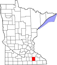 | |
| Townships | ||
| Unincorporated communities | ||
| Ghost town | ||
| Footnotes | ‡This populated place also has portions in an adjacent county or counties | |
| Core city |  | |
|---|---|---|
| Incorporated Places | ||
| Counties | ||
‡ indicates that it is partially in the metropolitan area. † indicates a county seat. | ||
Coordinates: 44°09′13″N 92°53′59″W / 44.15361°N 92.89972°W