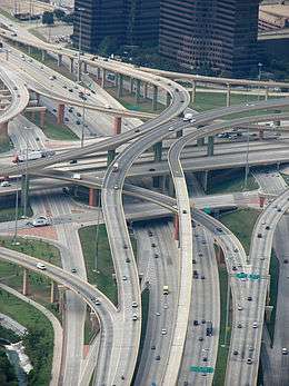
Local-express lanes
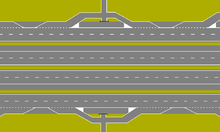

The local-express lane (also called collector–distributor lanes within a single interchange) system is an arrangement of roadways within a major highway where long distance traffic can use lanes with fewer interchanges compared to local traffic which use 'local' or 'collector' lanes that have access to all interchanges. Where highway ramps between express and local/collector lanes cross over another this is commonly known as braided ramps.[1][2][3][4][5][6]
Given the considerable overall width of this design, new suburban freeways are often designed with interchanges spaced far enough apart to avoid the need for parallel roadways.
Examples
Canada
- Ontario: Gardiner Expressway (formerly QEW) from Wickman Road (west of Kipling Avenue) to Royal York Road, in Toronto.
- Ontario: Highway 400 in York Region, from the Highway 7 interchange to south of Langstaff Road[7] (signed as exit 29 to Highway 7 rather than collector-express).
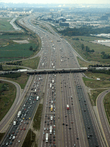
- Ontario: Highway 401 in Peel Region, Toronto and Durham Region.
- From Hurontario Street (newest section extended from Highway 410) to Highway 427.[8]
- From east of Kipling Avenue—serving the interchange with Highway 409—to west of Brock Road (Pickering)[9] (primary system).
- Ontario: Highway 404 traffic from westbound 401 and eastbound 401 has a brief collector-express separation and ends just north of Sheppard Avenue East.
- Ontario: Highway 403 from the Highway 401/410 interchange to Cawthra Road.
- Ontario: Highway 427 from Queen Elizabeth Way/Gardiner Expressway to Highway 401 in Toronto.
- Ontario: Conestoga Parkway from Lancaster Street to Krug Street in Kitchener, Ontario.
- Quebec: Autoroute 40 in Repentigny, Quebec.
- Nova Scotia: Nova Scotia Highway 118, in Dartmouth, Nova Scotia (southbound only).
United States
- California: State Route 180 at the State Route 41 and the State Route 168 interchanges. in Fresno. This interchange is unusual because it also allows traffic to flow between State Route 41 and State Route 168, bypassing the State Route 180 main line, making it almost a double braided ramp. Google Maps
- California: Interstate 5 at the El Toro Y in Irvine, and at the "5/805 merge" in Sorrento Valley, San Diego, California.
- California: Interstate 10 west of downtown Los Angeles from the Harbor Freeway (Interstate and State Route 110) to Arlington Avenue.
- California: Interstate 805 (northbound only) in Chula Vista, between the H Street and E Street/Bonita Road exits.
- California: California State Route 87 (Guadalupe Parkway). Northbound: from Interstate 280 to Julian Street along Downtown San Jose. Southbound: from Interstate 280 to Alma Avenue.
- California: U.S. Route 101 near San Francisco International Airport
- Florida: I-110 in Pensacola becomes a controlled-access freeway between the Airport Blvd and the Bayou Blvd exits.
- Georgia: I-85 in Atlanta, old HOV lane became express lane in 2011. 16 miles between Exit 94 and Exit 109.
- Illinois: The Dan Ryan Expressway and Kennedy Expressway (Interstates 90 and 94 in Chicago), between 71st Street and Interstate 55 (Dan Ryan), and between Ohio Street (Chicago) and the Edens (Kennedy).
- Illinois: Palatine Road between Illinois Route 53 and Sanders Road through the north suburbs of Chicago has grade-level express lanes, local lanes, and interchanges with the exception of the overpasses at Elmhurst Road and Milwaukee Avenue and an underpass at Wolf Road. It is not a freeway; instead it is called a "junior expressway".[10] Grade-level intersections require vehicles to execute left hook turns from the outer local lanes.
- Illinois: Illinois Route 53 between Interstate 290 at its south end and Kirchhoff Road follows a local-express format.
- Indiana: The Borman Expressway (I-94) in Gary.
- Indiana: The I-65/I-70 junction in Indianapolis.
- Maryland: Interstate 270 in Montgomery County (between Montrose Road and Interstate 370).
- Maryland: Interstate 95 in Baltimore County (between White Marsh and Baltimore).
- Michigan: The Jeffries Freeway (I-96) in Detroit.
- Nebraska: West Dodge Road (U.S. Route 6) in Omaha, becomes a controlled-access freeway (the West Dodge Freeway) at westbound 93rd Street with elevated local-express lanes that allow drivers to bypass the 114th and 120th Street intersections. The express lanes are known locally as the West Dodge Expressway.
- Nevada: Interstate 15 in Las Vegas, between Russell Road and Sahara Avenue (opened to traffic October 2009) and between Blue Diamond Road and Russell Road (northbound opened to traffic November 2011 and southbound currently under construction).
- New Jersey: The Garden State Parkway in New Jersey from the Raritan tolls to the Asbury Park tolls.
- New Jersey: Interstate 76 in southern New Jersey (westbound only) from Interstate 295 to U.S. Highway 130 approaching the Walt Whitman Bridge.
- New Jersey: Interstate 78 in northern New Jersey (between the New Jersey Turnpike and Route 24).
- New Jersey: Interstate 80 in northern New Jersey (Interstate 95-Garden State Parkway and Interstate 280-Interstate 287).
- New Jersey: U.S. Route 1/9 in northern New Jersey from Route 81 to US 1/9 Truck).
- New Jersey: Route 3 in northern New Jersey (between the New Jersey Turnpike western spur and New Jersey Route 495).
- New Jersey: Interstate 287 in central/north Jersey from Interstate 78 to U.S. Route 202/206.
- New Jersey/New York: Interstate 95 from Interstate 276 to Alexander Hamilton Bridge (varies from inner car lanes and outer truck lanes to traditional express-local lane setup and upper-level/lower-level on the George Washington Bridge).
- New York: Westchester Avenue in Harrison at exits 9S and 9N from Interstate 287.
- New York: Interstate 495 in Elmhurst at exit 19.
- Ohio: Interstate 271 in Greater Cleveland between Interstate 480 in North Randall and Interstate 90 in Willoughby Hills.
- Pennsylvania: Roosevelt Boulevard (US 1) in Northeast Philadelphia is similarly a surface road with express and local roadways.
- Texas: US Route 54 (Patriot Freeway), in east central El Paso, from Interstate 10 interchange northward to Pershing Drive (entrance to Fort Bliss).
- Texas: Interstate 35, on the northwest corner of central San Antonio, from near the Exit 158 interchange with Interstate 37 to the Exit 156 interchange with Interstate 10.
- Texas: Interstate 35/Interstate 10 on the southwest corner of central San Antonio from near the Exit 155A interchange with TX Spur 536 to the Exit 154A interchange with TX Loop 353.
- Virginia: Virginia State Route 37 (Winchester Bypass), in Winchester, from Interstate 81 north to Virginia State Route 7.
- Washington: Interstate 5 through downtown Seattle, from downtown to Northgate Way and Interstate 90 through the Mount Baker Tunnel over the Homer M. Hadley Memorial Bridge across Mercer Island to Bellevue across the East Channel Bridge.
- Washington D.C./Virginia/Maryland: Interstate 495 (Capital Beltway) in the Washington, D.C. metro area, between Telegraph Road in Alexandria, Virginia, and State Route 210 in Oxon Hill, Maryland, as the freeway crosses the Potomac River via the Woodrow Wilson Bridge.
Other countries
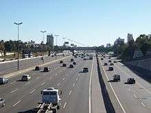
- North Access freeway - National Route 9 from Vicente López to San Isidro at Buenos Aires, Argentina

_03.jpg)
- A6 motorway (France), south of Paris
- A2 (/ N2), sections around Eindhoven, 's-Hertogenbosch, and Utrecht (all Netherlands)
- A4 The Hague and near Schiphol Netherlands have a basketweave braid in between two adjacent interchanges. Section around Leiden as well.
- A12, Utrecht, Netherlands
- A15, Rotterdam, Netherlands
- A16, Rotterdam, Netherlands
- M60 motorway, Manchester, England
- M20 motorway, Maidstone, England
- M8 motorway, Glasgow, Scotland
- A38 road, Plymouth, England
- M30 motorway, Madrid, Spain
- AP-7, near Barcelona, Spain
- Marginal Tiete, São Paulo, Brazil
- Marginal Pinheiros, São Paulo, Brazil
- Avenida das Américas, Rio de Janeiro, Brazil
- Avenida Brasil, Rio de Janeiro, Brazil
- Via Rápida Poniente y Oriente, Tijuana, Mexico
- Between Yenikapı - Bakırköy, Istanbul, Turkey
- M1 West Gate Freeway, between the M2 and Burnley Tunnel in Melbourne, Australia.
- Gloucester Road (west-bound from Canal Road West to Fenwick Street), Wan Chai, Hong Kong
- Prince Edward Road West (elevated and lower roadway from Pentland Street to Choi Hung Road), Kowloon, Hong Kong
- N1 outbound between Koeberg Road and the N7, in Cape Town, South Africa
- Lahore Ring Road, an 85 km long, 6 lane wide Ring Road around Lahore, Pakistan
- North-South Expressway Northern Route, between Jelapang and Ipoh South.
- Prof. Dr. Sedyatmo Toll Road, between Pluit and Penjaringan, Jakarta, Indonesia.
- D1/Einsteinova in Bratislava-Petržalka, Slovakia
- S2 in Warsaw, Poland → see map
Gallery
 A view of North Access's Freeway at Buenos Aires, Argentina from the bridge on Pres H.Yrigoyen street at Florida, Buenos Aires, Argentina
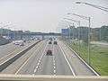 Express (cars only) and local (all vehicles) setup along Interstate 95 in Monroe Township, New Jersey.
 Express to collector transfer on Highway 401.
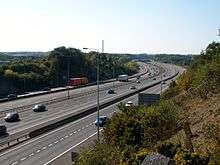
 Local-Express lanes on Interstate 270 in Montgomery County, Maryland.
 Collector-Express roadway configuration on Highway 401 in Toronto.
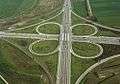
Example of cloverleaf interchanges
A cloverleaf interchange may have collector–distributor lanes on a freeway or expressway to handle entering and exiting traffic. Usually, this lane will begin as an entrance-only ramp initially, but it will sometimes become a main lane or possibly an exit-only lane. The purpose of this lane is to facilitate traffic to the freeway exits and from the freeway entrances.


References
- ↑ VDOT: Braided Ramp Demo. YouTube (2009-02-26). Retrieved on 2013-07-16.
- ↑ I-5 196th Braided Ramp animation. YouTube (2010-12-02). Retrieved on 2013-07-16.
- ↑ WSDOT - Project - I-405 – NE 8th St to SR 520 Braided Ramps – Interchange Improvements - Complete May 2012. Wsdot.wa.gov. Retrieved on 2013-07-16.
- ↑ ftp://ftp.dot.state.tx.us/pub/txdot-info/rti/psr/5105.pdf
- ↑ TxDOT IH-10 Section 3. PGAL. Retrieved on 2013-07-16.
- ↑ State Route 180 Braided Ramps Project. Dot.ca.gov. Retrieved on 2013-07-16.
- ↑ Tele Atlas. "Driving directions to Unknown road". Google Maps. Mountain View, U.S.A.: Google. Retrieved 2009-04-30.
- ↑ Tele Atlas. "Driving directions to King's Hwy 401/MacDonald-Cartier Fwy". Google Maps. Mountain View, U.S.A.: Google. Retrieved 2009-04-28.
- ↑ Tele Atlas. "Driving directions to King's Hwy 401/MacDonald-Cartier Fwy/Hwy of Heroes". Google Maps. Mountain View, U.S.A.: Google. Retrieved 2009-04-28.
- ↑ Carlson, Rich. As documented in Wikipedia:WikiProject Illinois State Routes/External correspondence#What is a Junior expressway?
External links
 Media related to Local-express lanes at Wikimedia Commons