Cullman County, Alabama
| Cullman County, Alabama | |
|---|---|
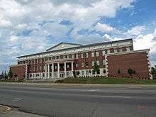 The Cullman County Courthouse | |
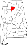 Location in the U.S. state of Alabama | |
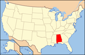 Alabama's location in the U.S. | |
| Founded | January 24, 1877 |
| Named for | John G. Cullmann |
| Seat | Cullman |
| Largest city | Cullman |
| Area | |
| • Total | 755 sq mi (1,955 km2) |
| • Land | 735 sq mi (1,904 km2) |
| • Water | 20 sq mi (52 km2), 2.7% |
| Population (est.) | |
| • (2015) | 82,005 |
| • Density | 109/sq mi (42/km²) |
| Congressional district | 4th |
| Time zone | Central: UTC-6/-5 |
| Website |
www |
|
Footnotes:
| |
Cullman County is a county of the U.S. state of Alabama. As of the 2010 census, the population was 80,406.[1] Its county seat is Cullman.[2] Its name is in honor of Colonel John G. Cullmann. It is a "moist" county in terms of availability of alcoholic beverages; the cities of Cullman, Good Hope and Hanceville allow sale of alcohol and are "wet" and the rest of the county is dry.
Cullman County comprises the Cullman, AL Micropolitan Statistical Area, which is a component of the Birmingham-Hoover-Talladega, AL Combined Statistical Area.
Cullman is served by TV stations and FM radio stations from both Huntsville and Birmingham. Cullman County is a part of the designated market area, or "DMA," of Birmingham. Electricity in Cullman County is provided by the Tennessee Valley Authority and by the Alabama Power Company. For a long time, telephone service in this county was provided by the Southern Bell Company.
There is no commercial air transportation service in Cullman County, and this county is no longer served by intercity commercial buses.
History
This area was inhabited for thousands of years by varying cultures of indigenous peoples. The historic Cherokee and Choctaw lived here at the time of European encounter, with the Cherokee moving in after the American Revolutionary War and in response to pressures from northern area. Their settlements in Alabama were known as the Lower Towns.
People claiming descent from Cherokee who remained in the county after Indian Removal in the 1830s, organized as the "Echota Cherokee Tribe of Alabama" in the 1980s. The tribe was recognized by the state in 1984 but is not federally recognized. It claims 22,000 members in the state, mostly in northern Alabama.[3]
Cullman County was organized in 1877 primarily by German American immigrants who had moved down from Cincinnati, Ohio. They founded an agricultural community and sought to create an agricultural revolution in what had been a frontier area, in the best traditions of innovation in the New South. However, hard geographical and social realities clashed with the often impractical vision of colonizer John G. Cullmann. His Germans, with their traditional work ethic and willingness to experiment with such new products as wine and strawberries, tried to make practical changes in southern farming. The Germans were outnumbered by more traditional families from neighboring regions, who replicated the traditional southern cotton culture.
Geography
According to the U.S. Census Bureau, the county has a total area of 755 square miles (1,960 km2), of which 735 square miles (1,900 km2) is land and 20 square miles (52 km2) (2.7%) is water.[4]
Adjacent counties
- Morgan County (north)
- Marshall County (northeast)
- Blount County (east)
- Walker County (southwest)
- Winston County (west)
- Lawrence County (northwest)
Transportation
Major highways
Rail
Demographics
| Historical population | |||
|---|---|---|---|
| Census | Pop. | %± | |
| 1880 | 6,355 | — | |
| 1890 | 13,439 | 111.5% | |
| 1900 | 17,849 | 32.8% | |
| 1910 | 28,321 | 58.7% | |
| 1920 | 33,034 | 16.6% | |
| 1930 | 41,051 | 24.3% | |
| 1940 | 47,343 | 15.3% | |
| 1950 | 49,046 | 3.6% | |
| 1960 | 45,572 | −7.1% | |
| 1970 | 52,445 | 15.1% | |
| 1980 | 61,642 | 17.5% | |
| 1990 | 67,613 | 9.7% | |
| 2000 | 77,483 | 14.6% | |
| 2010 | 80,406 | 3.8% | |
| Est. 2015 | 82,005 | [5] | 2.0% |
| U.S. Decennial Census[6] 1790–1960[7] 1900–1990[8] 1990–2000[9] 2010–2015[1] | |||
As of the census[10] of 2000, there were 77,483 people, 30,706 households, and 22,476 families residing in the county. The population density was 105 people per square mile (41/km2). There were 35,233 housing units at an average density of 48 per square mile (18/km2). The racial makeup of the county was 96.81% White, 0.96% Black or African American, 0.37% Native American, 0.18% Asian, 0.03% Pacific Islander, 0.62% from other races, and 1.03% from two or more races. 2.18% of the population were Hispanic or Latino of any race.
There were 30,706 households out of which 32.10% had children under the age of 18 living with them, 60.80% were married couples living together, 8.70% had a female householder with no husband present, and 26.80% were non-families. 24.00% of all households were made up of individuals and 10.40% had someone living alone who was 65 years of age or older. The average household size was 2.49 and the average family size was 2.94.
In the county the population was spread out with 24.30% under the age of 18, 8.80% from 18 to 24, 28.30% from 25 to 44, 24.00% from 45 to 64, and 14.60% who were 65 years of age or older. The median age was 38 years. For every 100 females there were 97.30 males. For every 100 females age 18 and over, there were 94.20 males.
The median income for a household in the county was $32,256, and the median income for a family was $39,341. Males had a median income of $30,444 versus $20,436 for females. The per capita income for the county was $16,922. About 9.50% of families and 13.00% of the population were below the poverty line, including 14.50% of those under age 18 and 16.80% of those age 65 or over.
2010 census
As of the census[11] of 2010, there were 80,406 people, 31,864 households, and 22,487 families residing in the county. The population density was 109 people per square mile (42/km2). There were 37,054 housing units at an average density of 49 per square mile (18/km2). The racial makeup of the county was 94.7% White, 1.1% Black or African American, 0.5% Native American, 0.4% Asian, 0.0% Pacific Islander, 2.2% from other races, and 1.1% from two or more races. 4.3% of the population were Hispanic or Latino of any race.
There were 31,864 households out of which 28.0% had children under the age of 18 living with them, 55.2% were married couples living together, 10.4% had a female householder with no husband present, and 29.4% were non-families. 25.7% of all households were made up of individuals and 11.0% had someone living alone who was 65 years of age or older. The average household size was 2.49 and the average family size was 2.98.
In the county the population was spread out with 23.2% under the age of 18, 8.6% from 18 to 24, 24.8% from 25 to 44, 27.5% from 45 to 64, and 15.9% who were 65 years of age or older. The median age was 39.9 years. For every 100 females there were 97.6 males. For every 100 females age 18 and over, there were 100.9 males.
The median income for a household in the county was $38,567, and the median income for a family was $47,771. Males had a median income of $36,952 versus $27,979 for females. The per capita income for the county was $20,284. About 12.8% of families and 16.7% of the population were below the poverty line, including 21.6% of those under age 18 and 12.6% of those age 65 or over.
Education
Public education in Cullman County is provided by two systems: the Cullman City School Board and the Cullman County School Board, which governs all municipalities except the City of Cullman.
- Cullman High School - under the governance of the Cullman City School Board
Private educational institutions in the county include:
- Christ Covenant School - located in Cullman (Grades K-2)
- Cullman Christian School - located in Cullman (Grades K-12)
- Sacred Heart of Jesus Catholic Elementary School - located in Cullman (Grades PreK-6)
- St. Bernard Preparatory School - located in Cullman (Grades 7-12)
- St. Paul's Lutheran School - located in Cullman (Grades K-6)
- Vinemont Christian Academy - located in South Vinemont (Grades PreK-12)
Cullman is also the home of Wallace State Community College in Hanceville. It was named for the former Governor of Alabama, George C. Wallace. The public, non-profit college opened its doors in 1966 and has grown to become the third largest community college in the state of Alabama, with an enrollment of around 6,000 students. The college is accredited by the Southern Association of Colleges and Schools Commission on Colleges to award degrees. Many programs have additional accreditation from organizations appropriate to the particular disciplines. Wallace State offers hundreds of degree and certificate options in dozens of programs in its Academic, Health and Technical Divisions. The college offers more Health programs than any other community college in the state. The college offers early enrollment through its Dual Enrollment, Fast Track Academy and Fast Track for Industry programs, the latter of which is funded through grants that allow free tuition for qualified students entering the technical, academic and health programs included in the program. The college's current president is Dr. Vicki P. Karolewics, who is the institution's third president in 50 years. She was preceded by Dr. James C. Bailey from 1971 to 2003 and Dr. Ben Johnson from 1965 to 1971. The college is located in the southern portion of Cullman County on a verdant 300-acre campus that includes state-of-the-art facilities, men's and women's dormitories and multiple recreational opportunities. The college boasts several national championship athletic teams and competes in Division I of the National Junior College Athletic Association. Athletic programs at Wallace State include men's and women's basketball, baseball, softball, men's and women's golf, men's and women's tennis, volleyball and cheerleading.
Government
| Year | GOP | DNC | Others |
|---|---|---|---|
| 2016 | 87.2% 32,734 | 9.9% 3,730 | 2.9% 1,074 |
| 2012 | 84.2% 27,930 | 14.6% 4,855 | 1.2% 393 |
| 2008 | 81.9% 28,896 | 16.6% 5,864 | 1.5% 545 |
| 2004 | 76.2% 26,818 | 22.9% 8,045 | 0.9% 328 |
| 2000 | 64.9% 19,157 | 33.0% 9,758 | 2.1% 610 |
Communities
Cities
- Arab (mostly in Marshall County)
- Cullman (county seat)
- Good Hope
- Hanceville
Towns
Census-designated places
Unincorporated communities
See also
- National Register of Historic Places listings in Cullman County, Alabama
- Properties on the Alabama Register of Landmarks and Heritage in Cullman County, Alabama
References
- 1 2 "State & County QuickFacts". United States Census Bureau. Retrieved May 16, 2014.
- ↑ "Find a County". National Association of Counties. Archived from the original on 2011-05-31. Retrieved 2011-06-07.
- ↑ Alabama Indian Affairs Commission. "Tribes Recognized by the State of Alabama". Retrieved 2011-02-09.
- ↑ "2010 Census Gazetteer Files". United States Census Bureau. August 22, 2012. Retrieved August 22, 2015.
- ↑ "County Totals Dataset: Population, Population Change and Estimated Components of Population Change: April 1, 2010 to July 1, 2015". Retrieved July 2, 2016.
- ↑ "U.S. Decennial Census". United States Census Bureau. Archived from the original on May 11, 2015. Retrieved August 22, 2015.
- ↑ "Historical Census Browser". University of Virginia Library. Retrieved August 22, 2015.
- ↑ Forstall, Richard L., ed. (March 24, 1995). "Population of Counties by Decennial Census: 1900 to 1990". United States Census Bureau. Retrieved August 22, 2015.
- ↑ "Census 2000 PHC-T-4. Ranking Tables for Counties: 1990 and 2000" (PDF). United States Census Bureau. April 2, 2001. Retrieved August 22, 2015.
- ↑ "American FactFinder". United States Census Bureau. Archived from the original on 2013-09-11. Retrieved 2011-05-14.
- ↑ "American FactFinder". United States Census Bureau. Archived from the original on 2013-09-11. Retrieved 2015-07-20.
- ↑ "Dave Leip's Atlas of U.S. Presidential Elections". Retrieved November 16, 2016.
External links
Further reading
- Davis, Robert S., “The Old World in the New South: Entrepreneurial Ventures and the Agricultural History of Cullman County, Alabama,” Agricultural History, 79 (Fall 2005), 439–61.
 |
Lawrence County | Morgan County | Marshall County | |
| Winston County | |
Blount County | ||
| ||||
| | ||||
| Walker County |
Municipalities and communities of Cullman County, Alabama, United States | ||
|---|---|---|
| Cities | | |
| Towns | ||
| CDPs | ||
| Unincorporated communities | ||
| Footnotes | ‡This populated place also has portions in an adjacent county or counties | |
Coordinates: 34°08′N 86°52′W / 34.133°N 86.867°W