Hale County, Alabama
| Hale County, Alabama | |
|---|---|
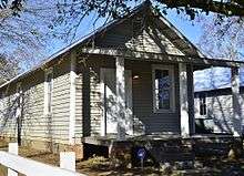
 Hale County Courthouse in Greensboro | |
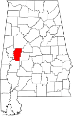 Location in the U.S. state of Alabama | |
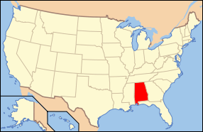 Alabama's location in the U.S. | |
| Founded | January 30, 1867 |
| Named for | Stephen F. Hale |
| Seat | Greensboro |
| Largest city | Greensboro |
| Area | |
| • Total | 657 sq mi (1,702 km2) |
| • Land | 644 sq mi (1,668 km2) |
| • Water | 13 sq mi (34 km2), 1.9% |
| Population (est.) | |
| • (2015) | 15,068 |
| • Density | 24/sq mi (9/km²) |
| Congressional district | 7th |
| Time zone | Central: UTC-6/-5 |
|
Footnotes:
| |
Hale County is a county of the U.S. state of Alabama. As of the 2010 census, the population was 15,760.[1] Its county seat is Greensboro.[2] It is named in honor of Confederate officer Stephen Fowler Hale.[3]
Hale County is part of the Tuscaloosa, AL Metropolitan Statistical Area.
History
Hale County was established following the end of the American Civil War, on January 30, 1867. Located in the west-central section of the state, it was created from portions of Greene, Marengo, Perry, and Tuscaloosa counties. The vast majority came from Greene County. The first American settlers hailed from Georgia, Tennessee, Kentucky, and the Carolinas.[4][5]
Hale County is connected to three major twentieth century artists: Walker Evans photographed the area in 1936 while he collaborated with James Agee on the 1941 book Let Us Now Praise Famous Men. Since the 1960s, artist William Christenberry, born in Tuscaloosa, has been photographing various structures in Hale County as part of his multi-media artistic investigations. More recently, Hale County has become the home of the nationally-recognized Auburn University Rural Studio, an architectural outreach program founded by architect and artist Samuel Mockbee and D. K. Ruth.[5] It is also the birthplace of Eugene Sawyer, the second African American mayor of Chicago.[6]
Since the American Civil War, whites controlled economic and political power in Hale County. However, in 1997 after a highly contested mayoral election the city of Greensboro elected its first black mayor, John E. Owens Jr. The first African American chief of police was appointed in 2000, Claude Hamilton. In 2006, both black and white county residents came together and elected their first black sheriff, Kenneth W. Ellis, who was formerly the Moundville police chief.
Like many Blackbelt counties, Hale County has experienced economic decline, particularly in the southern end of the county. Many businesses and manufacturing plants have closed in and around Greensboro (the county seat). The northern portion of the county, however, has experienced population and industrial growth due to its close proximity to Tuscaloosa County
Geography
According to the U.S. Census Bureau, the county has a total area of 657 square miles (1,700 km2), of which 644 square miles (1,670 km2) is land and 13 square miles (34 km2) (1.9%) is water.[7]
Adjacent counties
- Tuscaloosa County (north)
- Bibb County (northeast)
- Perry County (southeast)
- Marengo County (south)
- Greene County (west)
National protected area
- Talladega National Forest (part)
Demographics
| Historical population | |||
|---|---|---|---|
| Census | Pop. | %± | |
| 1870 | 21,792 | — | |
| 1880 | 26,553 | 21.8% | |
| 1890 | 27,501 | 3.6% | |
| 1900 | 31,011 | 12.8% | |
| 1910 | 27,883 | −10.1% | |
| 1920 | 24,289 | −12.9% | |
| 1930 | 26,265 | 8.1% | |
| 1940 | 25,533 | −2.8% | |
| 1950 | 20,832 | −18.4% | |
| 1960 | 19,537 | −6.2% | |
| 1970 | 15,888 | −18.7% | |
| 1980 | 15,604 | −1.8% | |
| 1990 | 15,498 | −0.7% | |
| 2000 | 17,185 | 10.9% | |
| 2010 | 15,760 | −8.3% | |
| Est. 2015 | 15,068 | [8] | −4.4% |
| U.S. Decennial Census[9] 1790–1960[10] 1900–1990[11] 1990–2000[12] 2010–2015[1] | |||
As of the 2010 United States Census, there were 15,760 people residing in the county. 59.0% were Black or African American, 39.8% White, 0.2% Asian, 0.2% Native American, 0.3% of some other race and 0.6% of two or more races. 0.9% were Hispanic or Latino (of any race).
As of the census[13] of 2000, there were 17,185 people, 6,415 households, and 4,605 families residing in the county. The population density was 27 people per square mile (10/km2). There were 7,756 housing units at an average density of 12 per square mile (5/km2). The racial makeup of the county was 39.83% White, 58.95% Black or African American, 0.17% Native American, 0.16% Asian, 0.02% Pacific Islander, 0.29% from other races, and 0.58% from two or more races. 0.91% of the population were Hispanic or Latino of any race.
There were 6,415 households out of which 36.50% had children under the age of 18 living with them, 45.60% were married couples living together, 22.00% had a female householder with no husband present, and 28.20% were non-families. 26.40% of all households were made up of individuals and 10.90% had someone living alone who was 65 years of age or older. The average household size was 2.63 and the average family size was 3.19.
In the county the population was spread out with 29.60% under the age of 18, 9.10% from 18 to 24, 26.70% from 25 to 44, 21.10% from 45 to 64, and 13.50% who were 65 years of age or older. The median age was 34 years. For every 100 females there were 89.40 males. For every 100 females age 18 and over, there were 83.60 males.
The median income for a household in the county was $25,807, and the median income for a family was $31,875. Males had a median income of $28,493 versus $19,363 for females. The per capita income for the county was $12,661. About 22.20% of families and 26.90% of the population were below the poverty line, including 34.00% of those under age 18 and 26.70% of those age 65 or over.
Government and infrastructure
The Farquhar Cattle Ranch, a former Alabama Department of Corrections facility for men,[14] was in an unincorporated area of the county, about 8 miles (13 km) east of Greensboro.[15]
| Year | GOP | DNC | Others |
|---|---|---|---|
| 2016 | 39.5% 3,172 | 59.4% 4,772 | 1.1% 92 |
| 2012 | 37.1% 3,205 | 62.6% 5,401 | 0.3% 22 |
| 2008 | 39.0% 3,200 | 60.6% 4,982 | 0.4% 32 |
| 2004 | 41.3% 3,281 | 58.3% 4,631 | 0.4% 33 |
| 2000 | 38.6% 2,984 | 60.2% 4,652 | 1.2% 95 |
Transportation
Major highways
Airports
- Greensboro Municipal Airport (7A0) in Greensboro
- Moundville Airport (L44) in Moundville
Tourism
Greensboro, the county seat, is home to the 'Safe House Museum'. On March 21, 1968, Martin Luther King Jr. attended a meeting at Greensboro's St. Matthew Church, and then spent the night in this house where he sought refuge from the Ku Klux Klan. The museum reveals the struggle for equality for African Americans in Alabama, and its curator, Ms. Theresa Burroughs, was both a family friend of King, and a foot soldier in the Civil Rights Movement.[5][17]
Greensboro is also home to a large number of antebellum-era houses and churches, including some that are listed on the National Register of Historic Places such as Glencairn and Magnolia Grove.[5][18]
Communities
Cities
- Greensboro (county seat)
- Moundville (partly in Tuscaloosa County)
Towns
Unincorporated communities
Ghost towns
See also
- National Register of Historic Places listings in Hale County, Alabama
- Properties on the Alabama Register of Landmarks and Heritage in Hale County, Alabama
References
- 1 2 "State & County QuickFacts". United States Census Bureau. Retrieved May 16, 2014.
- ↑ "Find a County". National Association of Counties. Retrieved 2011-06-07.
- ↑ Gannett, Henry (1905). The Origin of Certain Place Names in the United States. Govt. Print. Off. p. 147.
- ↑ "Alabama Counties: Hale County". Alabama Department of Archives and History. State of Alabama. Retrieved September 1, 2011.
- 1 2 3 4 "Hale County". The Encyclopedia of Alabama. Auburn University. Retrieved September 1, 2011.
- ↑ "Former Mayor Eugene Sawyer Dies", Chicago Tribune, January 20, 2008
- ↑ "2010 Census Gazetteer Files". United States Census Bureau. August 22, 2012. Retrieved August 22, 2015.
- ↑ "County Totals Dataset: Population, Population Change and Estimated Components of Population Change: April 1, 2010 to July 1, 2015". Retrieved July 2, 2016.
- ↑ "U.S. Decennial Census". United States Census Bureau. Retrieved August 22, 2015.
- ↑ "Historical Census Browser". University of Virginia Library. Retrieved August 22, 2015.
- ↑ Forstall, Richard L., ed. (March 24, 1995). "Population of Counties by Decennial Census: 1900 to 1990". United States Census Bureau. Retrieved August 22, 2015.
- ↑ "Census 2000 PHC-T-4. Ranking Tables for Counties: 1990 and 2000" (PDF). United States Census Bureau. April 2, 2001. Retrieved August 22, 2015.
- ↑ "American FactFinder". United States Census Bureau. Retrieved 2011-05-14.
- ↑ "Farquhar Cattle Ranch" (Archive). Alabama Department of Corrections. Retrieved on June 17, 2014. "Street Address: 1132 County Rd. 73 Greensboro, AL 36744"
- ↑ "Crime Beat" (Archive). Tuscaloosa News. Monday April 9, 2012. Retrieved on June 17, 2014.
- ↑ "Dave Leip's Atlas of U.S. Presidential Elections". Retrieved November 15, 2016.
- ↑ "Safehouse Black History Museum at Greensboro, Alabama". Rural Southwest Alabama. April 25, 2012. Retrieved Feb 2013. Check date values in:
|access-date=(help) - ↑ National Park Service (2008-04-15). "National Register Information System". National Register of Historic Places. National Park Service.
External links
- Moundville Archaeological Park, Hale County, AL
- William Christenberry: Place, Time, and Memory Southern Spaces September 28, 2007
 |
Tuscaloosa County | Bibb County | | |
| Greene County | |
|||
| ||||
| | ||||
| Marengo County | Perry County |
Municipalities and communities of Hale County, Alabama, United States | ||
|---|---|---|
| City | | |
| Towns | ||
| Unincorporated communities | ||
| Ghost towns | ||
| Footnotes | ‡This populated place also has portions in an adjacent county or counties | |
Coordinates: 32°45′39″N 87°37′47″W / 32.76083°N 87.62972°W