Harford County, Maryland
| Harford County, Maryland | |||
|---|---|---|---|
| County | |||
| Harford County | |||
|
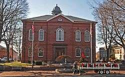
Harford County Courthouse | |||
| |||
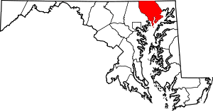 Location in the U.S. state of Maryland | |||
 Maryland's location in the U.S. | |||
| Founded | December 17, 1773 | ||
| Named for | Henry Harford | ||
| Seat | Bel Air | ||
| Largest city | Aberdeen | ||
| Area | |||
| • Total | 527 sq mi (1,365 km2) | ||
| • Land | 437 sq mi (1,132 km2) | ||
| • Water | 90 sq mi (233 km2), 17% | ||
| Population (est.) | |||
| • (2015) | 250,290 | ||
| • Density | 475/sq mi (183/km²) | ||
| Congressional districts | 1st, 2nd | ||
| Time zone | Eastern: UTC-5/-4 | ||
| Website |
www | ||

Harford County is a county in the U.S. state of Maryland. As of the 2010 census, the population was 244,826.[1] Its county seat is Bel Air.[2]
Harford County is included in the Baltimore-Columbia-Towson, MD Metropolitan Statistical Area, which is also included in the Washington-Baltimore-Arlington, DC-MD-VA-WV-PA Combined Statistical Area.
History
Harford County was formed in 1773 from the eastern part of Baltimore County. It contains Tudor Hall, birthplace of Abraham Lincoln's assassin, John Wilkes Booth. Harford County also hosted the signers of the Bush Declaration, a precursor document to the American Revolution.
The county was named for Henry Harford (ca. 1759–1834), the illegitimate son of Frederick Calvert, 6th Baron Baltimore. Henry Harford was born to Calvert's mistress, Hester Whelan, whose residence still stands as part of a private residence on Jarretsville Pike, in Phoenix, Maryland. Harford served as the last Proprietary Governor of Maryland but, because of his illegitimacy, did not inherit his father's title.
Havre de Grace, an incorporated city in Harford County, was once under consideration to be the capital of the United States rather than Washington, D.C.. It was favored for its strategic location at the top of the Chesapeake Bay; this location would facilitate trade while being secure in time of war. Today, the waterways around Havre de Grace have become adversely affected by silt runoff, which is one of the primary environmental issues of Harford County.
The county has a number of properties on the National Register of Historic Places.[3]
Environmental history
Harford County has environmental issues in three major areas: land use, water pollution/urban runoff, and soil contamination/groundwater contamination.
The county's past, present, and future population booms and land development activities have created conflicts between farmers and developers/homeowners wishing to create subdivisions. The county was one of the first in the country to implement a development envelope plan, in which new development is channeled into specific areas of the county.
Because the county sits at the headwaters of the Chesapeake Bay along the Susquehanna River, it plays a key role in controlling sediment and fertilizer runoff into the bay as well as fostering submerged aquatic vegetation (SAV) regrowth. The county has had to balance the needs of land owners to practice agriculture and/or pave land (creating impervious surfaces) with effects of runoff into the bay.
Harford County has been burdened by soil contamination and groundwater contamination since the creation of the Aberdeen Proving Ground. The military installation performs research for the U.S. Army and has released various chemical agents into soil and groundwater, including mustard gas and perchlorate. The bordering towns of Aberdeen, Edgewood and Joppatowne have been affected by this contamination.[4][5] Aberdeen Proving Ground contains three Superfund priority sites as of 2006. Groundwater contamination by MTBE, a mandatory gasoline additive, has also affected Fallston.[6][7]
Harford County also faces controversy from residents living near Scarboro Landfill and Harford Waste Disposal Center, the only municipal landfill. The landfill, approved to triple in size in 2007, is the subject of complaints by neighbors of operating violations, such as large areas of open trash and blown litter, leachate breaks which contaminate area residential wells and flow into Deer Creek, a tributary of the Susquehanna River, and increased health problems.
Government
Harford County was granted a charter form of government in 1972. This means that the county is run by a County Executive and Council President, both elected at large, as well as Council Members, elected from districts. Currently, there are six districts in Harford County. Also elected at large is the Sheriff, who runs the Harford County Sheriff's Office.
Executive
The Harford County Executive is Barry Glassman (Republican).
Council
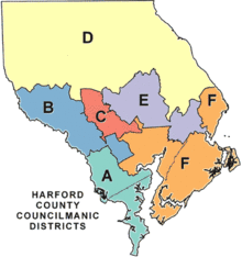
| District | Council Member |
|---|---|
| President | Richard Slutzky (R) |
| District A (Joppa, Edgewood) | Mike Perrone, Jr (R) |
| District B (Abingdon, Fallston) | Joseph Woods (R) |
| District C (Bel Air, Forest Hill) | James McMahan (R) |
| District D (Jarrettsville, Street, Darlington) | Chad Shrodes (R) |
| District E (Churchville, Aberdeen) | Patrick Vincenti (R) |
| District F (Belcamp, Havre de Grace) | Curtis Beulah (R) |
Sheriff
The current Sheriff is Jeffrey Gahler (R).
State's Attorney
The current State's Attorney is Joseph I. Cassilly
Departments
Directors are nominated by the Executive and approved by the Council.
| Department | Director |
|---|---|
| Administration | Billy Boniface |
| Community Services | Amber Shrodes |
| Economic Development | Karen Myers |
| Emergency Services | Edward Hopkins |
| Housing Agency | Leonard Parrish |
| Human Resources | James Richardson |
| Information and Communication Technology | Ted Pibil, Jr |
| Inspections, Licensing and Permits | Paul Lawder |
| Law | Melissa Lambert |
| Parks and Recreation | James Malone, Jr |
| Planning and Zoning | Bradley Killian |
| Procurement | Karen Rottmann |
| Public Works | Timothy Wittie |
| Treasury | Robert Sandlass |
Other departments
- Harford County Public Library is a public library system serving Harford County. It has 11 branches located throughout the county.
- Harford County Volunteer Fire & EMS Association is the chief fire & EMS force in Harford County. It is made up of all the volunteer fire companies located throughout the county. It currently has 11 fire departments & 1 EMS department.
Geography
According to the U.S. Census Bureau, the county has a total area of 527 square miles (1,360 km2), of which 437 square miles (1,130 km2) is land and 90 square miles (230 km2) (17%) is water.[8]
Harford County straddles the border between the rolling hills of the Piedmont Plateau and the flatlands of the Atlantic Coastal Plain along the Chesapeake Bay and its tributaries. The county's development is a mix of rural and suburban, with denser development in the larger towns of Aberdeen and Bel Air and along Route 40 and other major arteries leading out of Baltimore. The highest elevations are in the north and northwest of the county, reaching 805 ft. near the Pennsylvania border in the county's northwestern corner. The lowest elevation is sea level along the Chesapeake Bay.
Adjacent counties
- York County, Pennsylvania (north)
- Lancaster County, Pennsylvania (northeast)
- Baltimore County (west)
- Cecil County (east)
National protected area
Demographics
| Historical population | |||
|---|---|---|---|
| Census | Pop. | %± | |
| 1790 | 14,976 | — | |
| 1800 | 17,626 | 17.7% | |
| 1810 | 21,258 | 20.6% | |
| 1820 | 15,924 | −25.1% | |
| 1830 | 16,319 | 2.5% | |
| 1840 | 17,120 | 4.9% | |
| 1850 | 19,356 | 13.1% | |
| 1860 | 23,415 | 21.0% | |
| 1870 | 22,605 | −3.5% | |
| 1880 | 28,042 | 24.1% | |
| 1890 | 28,993 | 3.4% | |
| 1900 | 28,269 | −2.5% | |
| 1910 | 27,965 | −1.1% | |
| 1920 | 29,291 | 4.7% | |
| 1930 | 31,603 | 7.9% | |
| 1940 | 35,060 | 10.9% | |
| 1950 | 51,782 | 47.7% | |
| 1960 | 76,722 | 48.2% | |
| 1970 | 115,378 | 50.4% | |
| 1980 | 145,930 | 26.5% | |
| 1990 | 182,132 | 24.8% | |
| 2000 | 218,590 | 20.0% | |
| 2010 | 244,826 | 12.0% | |
| Est. 2015 | 250,290 | [10] | 2.2% |
| U.S. Decennial Census[11] 1790–1960[12] 1900–1990[13] 1990–2000[14] 2010–2015[1] | |||
2000 census
As of the census[15] of 2000, there were 218,590 people, 79,667 households, and 60,387 families residing in the county. The population density was 496 people per square mile (192/km²). There were 83,146 housing units at an average density of 189 per square mile (73/km²). The racial makeup of the county was 86.77% White, 9.27% African-American, 0.23% Native American, 1.52% Asian, 0.06% Pacific Islander, 0.69% from other races, and 1.47% from two or more races. 1.91% of the population were Hispanic or Latino of any race. 22.5% were of German, 13.1% Irish, 9.8% Italian, 9.2% English, 8.1% "American" and 6.0% Polish ancestry.
By 2006 the population of Harford County had risen 10.4% to 241,402.[16]
The 2005 report on race and ethnicity indicated the county's population was 82.8% non-Hispanic whites. The proportion of African-Americans in the county had risen to 11.5%. Hispanics were now 2.4% of the total population.[16]
In 2000 there were 79,667 households out of which 38.70% had children under the age of 18 living with them, 61.90% were married couples living together, 10.20% had a female householder with no husband present, and 24.20% were non-families. 19.70% of all households were made up of individuals and 6.80% had someone living alone who was 65 years of age or older. The average household size was 2.72 and the average family size was 3.14.
In the county the age distribution of the population shows 27.90% under the age of 18, 6.80% from 18 to 24, 31.60% from 25 to 44, 23.70% from 45 to 64, and 10.10% who were 65 years of age or older. The median age was 36 years. For every 100 females there were 96.00 males. For every 100 females age 18 and over, there were 92.50 males.
The median income for a household in the county was $57,234, and the median income for a family was $63,868. Males had a median income of $43,612 versus $30,741 for females. The per capita income for the county was $24,232. About 3.60% of families and 4.90% of the population were below the poverty line, including 5.80% of those under age 18 and 6.70% of those age 65 or over.
2010 census
As of the 2010 United States Census, there were 244,826 people, 90,218 households, and 66,335 families residing in the county.[17] The population density was 560.1 inhabitants per square mile (216.3/km2). There were 95,554 housing units at an average density of 218.6 per square mile (84.4/km2).[18] The racial makeup of the county was 81.2% white, 12.7% black or African American, 2.4% Asian, 0.3% American Indian, 0.1% Pacific islander, 0.9% from other races, and 2.5% from two or more races. Those of Hispanic or Latino origin made up 3.5% of the population.[17] In terms of ancestry, 28.1% were German, 19.8% were Irish, 12.2% were English, 9.9% were Italian, 6.8% were Polish, and 6.2% were American.[19]
Of the 90,218 households, 36.6% had children under the age of 18 living with them, 57.9% were married couples living together, 11.3% had a female householder with no husband present, 26.5% were non-families, and 21.5% of all households were made up of individuals. The average household size was 2.68 and the average family size was 3.13. The median age was 39.4 years.[17]
The median income for a household in the county was $77,010 and the median income for a family was $88,370. Males had a median income of $59,734 versus $44,706 for females. The per capita income for the county was $33,559. About 4.0% of families and 5.6% of the population were below the poverty line, including 7.3% of those under age 18 and 5.9% of those age 65 or over.[20]
Economy
According to the Maryland Department of Business and Economic Development, the following were the top employers in Harford County:
| Employer | # of Employees Nov. 2014[21] |
# of Employees Dec. 2011[22] |
|---|---|---|
| Aberdeen Proving Ground | 16,797 | 15,582 |
| Upper Chesapeake Health | 3,129 | 2,900 |
| Rite Aid (Mid-Atlantic Customer Support Center) |
1,300 | 1,500 |
| Kohl's | 1,255 | NA |
| Harford Community College | 1,029 | 982 |
| Klein's ShopRite of Maryland | 1,000 | 800 |
| Wal-Mart | 900 | 497 |
| Jacobs Technology | 865 | 787 |
| Home Depot | 500 | NA |
| Target Corporation | 500 | 495 |
| Wegmans Food Markets | 499 | 525 |
| BSC America | 475 | 250 |
| American Infrastructure | 445 | 352 |
| Macy's | 431 | NA |
| Booz Allen Hamilton | 430 | NA |
| McDonald's | 420 | NA |
| Computer Sciences Corporation (CSC) | 410 | 415 |
| Frito-Lay | 379 | 435 |
| Sephora USA | 378 | 454 |
| Leidos (formerly SAIC) |
370 | 607 |
| Independent Can | 350 | NA |
| Saks Fifth Avenue | 320 | 525 |
| CACI | 313 | 292 |
| APG Federal Credit Union | 305 | NA |
| SafeNet | 300 | NA |
| Areas USA | 251 | NA |
| Citizens Care & Rehabilitation Center | 250 | 250 |
| Dixie Construction | 250 | NA |
| Jones Junction Auto Group | 250 | NA |
| Northrop Grumman | 250 | 250 |
| Redner's Markets | 250 | 250 |
| Wawa | 250 | 252 |
| Giant Food | 249 | 378 |
| Mars Super Markets | 249 | NA |
| L-3 Communications | NA | 400 |
| Alcore | NA | 350 |
| Blue Dot of Maryland | NA | 330 |
| Custom Direct | NA | 295 |
| Weis Markets | NA | 290 |
| Constar | NA | 251 |
| Arc of Harford County | NA | 250 |
Education
Primary and secondary education
Harford County Public Schools
The Harford County Public Schools system is the public school system serving the residents of Harford County. It includes thirty-two elementary schools, nine middle schools, ten high schools and one charter school.
Private schools
- Harford Christian School a Christian school for pre-kindergarten through 12th grade.
- The John Carroll School, a Catholic school for 9th through 12th grade.
- Trinity Lutheran School a Lutheran school for pre-kindergarten through 8th grade.
- Harford Day School, a private school for Kindergarten through 8th grades.
- Harford Friends School, a Quaker school for Kindergarten through 8th grades.
- Saint Margaret School a Catholic school for pre-kindergarten through 8th grade.
Colleges
There are no 4-year universities in Harford County. Harford Community College, located in Churchville, offers 2-year associate degrees and vocational programs.
Sports
No major league sports teams are based in Harford County. The list of sports teams and organizations are shown below:
| Program | Colors | Conference | League | Facilities | Level |
| Aberdeen IronBirds | McNamara | New York–Penn League | Ripken Stadium | Short-Season A Minor League Baseball | |
| Harford Community College Fighting Owls | MD JUCO | NJCAA | Harford Sports Complex | College | |
| Aberdeen Eagles | Upper Chesapeake Bay Athletic Conference |
MPSSAA | Various | High School | |
| Bel Air Bobcats | |||||
| C. Milton Wright Mustangs | |||||
| Edgewood Rams | |||||
| Fallston Cougars | |||||
| Harford Technical Cobras | |||||
| Havre De Grace Warriors | |||||
| Joppatowne Mariners | |||||
| North Harford Hawks | |||||
| Patterson Mill Huskies | |||||
| Harford Christian Eagles | N/A | MACSAC | |||
| John Carroll Patriots | MIAA -B (Boys) IAAM (Girls) Baltimore Catholic League (Basketball) |
Harford County is the birthplace of many sports icons, including Kimmy Mizener, a 2006 Olympic figure skating competitor, Cal Ripken, a former Baltimore Orioles Hall of Famer and former Minnesota Vikings linebacker EJ Henderson.
Art and culture
The Susquehanna Symphony Orchestra, formerly the Harford Community Orchestra, is an orchestra that is based in Harford County. The group is made up of about 80 musicians from many professions.
The Havre De Grace Decoy Museum is a museum dedicated to working and decorative decoys used on the Chesapeake Bay.
Harford Community College hosts many cultural spots. The Student Center hosts the Chesapeake Gallery, a collection of artwork from established artists, as well as students and faculty, and the Chesapeake Theater, a theater venue used by the Phoenix Festival Theater Company, a student run theater group.
Harford Community College also has the Joppa Hall, which houses the Blackbox Theatre, an additional theater venue used by the Harford Dance Theater Company and the HCC Actors Guild. The Joppa Hall also houses the Joppa Recital Halls, a venue for musical performances.
Also at HCC is the Hays-Heighe House, a museum dedicated to the history of Harford County.
The Historical Society of Harford County, one of the oldest county historical societies in Maryland, was established in 1885 to preserve, promote, and interpret the history of the county and its people. Today, it is headquartered on Main Street in downtown Bel Air in the historic 1937 Old Bel Air Post Office Building, where it maintains an archive, exhibit space, and research library.
Media
The newspaper of record is The Aegis.
Several radio stations are located in Harford County, as shown in the table below:
| Call Sign | Frequency | City of License | Format |
|---|---|---|---|
| WAMD | 970 AM | Aberdeen | Top40 |
| WHFC | 91.1 FM | Bel Air | Variety |
| WHGM | 1330 AM/104.7 FM | Havre De Grace | Adult hits |
| WXCY | 103.7 FM | Havre De Grace | Country |
The Harford Cable Network, or HCN, provides local TV. It shows local government events, high school and Fighting Owl sporting events and religious programming, among others.
Transportation
Major highways
Mass transportation
Buses are run by the county-owned Harford Transit. The state-operated MARC Penn Line serves Edgewood and Aberdeen.
Airport
The Harford County Airport is a small airport in Churchville. Its available for recreational pilots & flight training, as well as sight seeing, balloon rides, hang gliding and sky diving.
Law enforcement
Primary law enforcement in the county is handled by the Harford County Sheriff's Office, which has precincts in Jarrettsville, Edgewood and Bel Air. The Maryland State Police also have a barrack located in Bel Air which serves the citizens of Harford County. Municipal police needs are provided by the Bel Air Police Department, the Aberdeen Police Department and the Havre De Grace Police Department.
Infrastructure
Health
Health services are provided by Upper Chesapeake Health System. Harford Memorial Hospital located in Havre De Grace and Upper Chesapeake Medical Center located in Bel Air form the two hospital system. UCHS is a member of the University of Maryland Medical System.
Communities
Cities
Town
- Bel Air (county seat)
Census-designated places
Unincorporated communities
Miscellaneous
The Conowingo Dam is on the eastern border of Harford County; the dam operations and offices are on the Harford County side of the river.
Many scenes from the films Tuck Everlasting and From Within, and the U.S. TV series House of Cards were filmed in various places around Harford County.
In 2011 the Office of National Drug Control Policy deemed Harford County a designated High Intensity Drug Trafficking Area.[23]
See also
References
- 1 2 "State & County QuickFacts". United States Census Bureau. Retrieved August 24, 2013.
- ↑ "Find a County". National Association of Counties. Retrieved 2011-06-07.
- ↑ National Park Service (2008-04-15). "National Register Information System". National Register of Historic Places. National Park Service.
- ↑ U.S. Environmental Protection Agency (EPA). Philadelphia. "Aberdeen Proving Ground (Edgewood Area Site) – Current Site Information." EPA Superfund Site ID No. MD2210020036. May 2008.
- ↑ EPA. "Aberdeen Proving Ground (Michaelsville Landfill) – Current Site Information." EPA Superfund Site ID No. MD3210021355. May 2008.
- ↑ Maryland Department of the Environment (MDE). Baltimore. "Fact Sheet – Drinking Water Well Impact: Fallston Presbyterian Church/Fallston Pre-Kindergarten, 600 Fallston Road, Fallston, Maryland." 2004-08-27.
- ↑ MDE. "Fact Sheet – Drinking Water Well Impact: Fallston Service Center, 602 Fallston Road, Fallston, Harford County, Maryland 21047." MDE Case No. 9-0816HA. 2004-12-01.
- ↑ "2010 Census Gazetteer Files". United States Census Bureau. August 22, 2012. Retrieved September 12, 2014.
- ↑ U.S. Fish & Wildlife Service, Cambridge, Maryland. "Susquehanna River National Wildlife Refuge: Overview".
- ↑ "County Totals Dataset: Population, Population Change and Estimated Components of Population Change: April 1, 2010 to July 1, 2015". Retrieved July 2, 2016.
- ↑ "U.S. Decennial Census". United States Census Bureau. Retrieved September 12, 2014.
- ↑ "Historical Census Browser". University of Virginia Library. Retrieved September 12, 2014.
- ↑ "Population of Counties by Decennial Census: 1900 to 1990". United States Census Bureau. Retrieved September 12, 2014.
- ↑ "Census 2000 PHC-T-4. Ranking Tables for Counties: 1990 and 2000" (PDF). United States Census Bureau. Retrieved September 12, 2014.
- ↑ "American FactFinder". United States Census Bureau. Retrieved 2008-01-31.
- 1 2 Harford County QuickFacts from the US Census Bureau
- 1 2 3 "DP-1 Profile of General Population and Housing Characteristics: 2010 Demographic Profile Data". United States Census Bureau. Retrieved 2016-01-22.
- ↑ "Population, Housing Units, Area, and Density: 2010 – County". United States Census Bureau. Retrieved 2016-01-22.
- ↑ "DP02 SELECTED SOCIAL CHARACTERISTICS IN THE UNITED STATES – 2006–2010 American Community Survey 5-Year Estimates". United States Census Bureau. Retrieved 2016-01-22.
- ↑ "DP03 SELECTED ECONOMIC CHARACTERISTICS – 2006–2010 American Community Survey 5-Year Estimates". United States Census Bureau. Retrieved 2016-01-22.
- ↑ Major Employers in Harford County, Maryland, Maryland Department of Business and Economic Development (Nov. 2014 data).
- ↑ Major Employers in Harford County, Maryland, Maryland Department of Business and Economic Development (Dec. 2011 data).
- ↑ "8 counties deemed drug trafficking areas". UPI.com. 2011-06-20. Retrieved 2013-01-27.
External links
| Wikimedia Commons has media related to Harford County, Maryland. |
- Harford County government
- Harford County Public Library
- Harford County Public Schools
- The Historical Society of Harford County
- Harford County at the Wayback Machine (archived March 29, 1997)
Coordinates: 39°32′N 76°18′W / 39.54°N 76.30°W
 |
York County, Pennsylvania | Lancaster County, Pennsylvania | | |
| Baltimore County | |
Cecil County | ||
| ||||
| | ||||
| Chesapeake Bay | Kent County |
Municipalities and communities of Harford County, Maryland, United States | ||
|---|---|---|
| Cities | | |
| Town | ||
| CDPs | ||
| Other communities | ||