East Coast Road
 49
| |
|---|---|
|
East Coast Road கிழக்கு கடற்கரைச்சாலை | |
| Route information | |
| Maintained by Tamil Nadu Road Development Corporation | |
| Length: | 690 km (430 mi) |
| Major junctions | |
| From: | Tiruvanmiyur, Chennai |
| To: | Pondicherry, Karaikal, Ramanathapuram, Kanyakumari |
| Location | |
| Districts: | Chennai, Kanchipuram, Vilupuram, Nagapattinam, Tiruvarur, Thanjavur, Pudukottai, Ramanathapuram, Tuticorin, Tirunelveli, Kanyakumari |
| Highway system | |
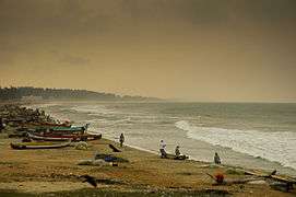
State Highway 49, also known as East Coast Road (ECR) (Tamil:கிழக்கு கடற்கரைச்சாலை) is a two lane highway in Tamil Nadu, India, built along the coast of the Bay of Bengal connecting Tamil Nadu's state capital city Chennai with Cuddalore via Pondicherry. Presently, the East Coast Road has been extended up to Kanyakumari via Chidambaram, Sirkali, Akkur, Tharagambadi,Karaikal, Nagore, Nagapattinam, Thiruthuraipoondi, Adirampattinam, Manora, Manamelkudi, Ramanathapuram, Koodankulam, Tuticorin.[1] The total length of the road is about 800 km from Chennai to Kanyakumari.

History
Prior to its completion, the East Coast Road mainly consisted of village roads connecting one fishermen hamlet to another. The vital connecting link then was the Old Mahabalipuram Road(SH-49A) till Mahabalipuram. Pondicherry was reached from Chennai through the still existent and busy route via Tambaram, Tindivanam along NH45. The road was built in 1998 by interlinking and improving a series of small village roads that connected the fishing villages along the east coast. The idea was to create infrastructure, facilitate inter-state connectivity and boost tourist movement. But within two years, it started showing signs of distress, adversely affecting the quality of rides and safety of motorists. In 2000, the State government signed a concessionaire agreement with the TNRDC in order to improve the road, at a cost of ₹ 60 crore.[2] The 113-km long stretch from Akkarai to Pondicherry, dotted with resorts and beach houses, became a toll facility in March 2002 and was upgraded into a two-lane road from a small winding road passing through 154 villages.[3] In 2010, TNRDC announced that toll collections had reached an all-time high at ₹ 1.08 crore in December 2009 against the ₹ 54.67 lakh collected in April 2002 when toll operations started. There were protests in Tamil Nadu after toll gates were added in 2002 for a road operating from 1998. In 2015, the ruling BJP government removed 60 toll gates in UP highways which were new and still collecting heavy toll from Tamil Nadu even 18 years after completion[4] In the 10th century AD when the Cholas ruled the whole of Southern India they used this road for Business Supply chain with Southern ports then it was called " Vadugaperuvazhi" in olden day means " The Big way to the North".[5]
ECR today

The ECR starts at Thiruvanmiyur in Chennai and is a part of the Chennai City roads till Uthandi. From Uthandi starts the scenic beachway section starts as a toll road. The speed of the vehicles on this road is restricted to a maximum of 80 km/h. The State Government is keen on expediting the proposal for four-laning of the East Coast Road (ECR). The State Highways Department is in the process of seeking certain geometrical changes in the present alignment of the ECR as a measure to reduce the number of fatal accidents.[6]
The ECR was made a toll road in April 2002. The ECR till Hanumanthai near Pondicherry is 113.2 km long and has a total of 22 bends. On an average 10,000 passenger car units (PCUs) use the road during rush hour and a total of 40,000 PCUs daily, up from about 5,000 daily before the construction of the road. The process of acquiring land for widening the 11.4-km stretch from Thiruvanmiyur to Akkarai covering six revenue villages (including Thiruvanmiyur, Kottivakkam, Palavakkam, Neelankarai, Injambakkam and Vettuvankani), which is under the control of the Highways Department, is under way.[7] The stretch currently has width varying between 50 ft and 80 ft. After widening at a sanctioned cost of ₹ 3,540 million, the stretch would be uniformly 30.5 m (100 ft) wide and would have six lanes, a 1.2-m-wide median, footpath-cum-stormwater drain.ECR extends up to Hanumanthai. On the way to Hanumanthai, a famous location Marakkanam is situated. On the ECR road right side famous Bhoomiswarar Temple is situated. It is believed that Sri Bhoomiswara is the God for Bhoomi, hence, many perform pooja before buying land placing the sale agreement on His holy feet. Hence real estate promoters also rush to this location.[8]


Places of interest
- Marundeeswarar Temple- Located about 4 km from Adayar and is one of the temples on the East Coast Road. Technically, this marks the beginning of the coastal road.
- Sholinganallur Prathyangira Devi Temple - The temple is located close to the junction and halfway down the link road of ECR and OMR. The Goddess, Shri Maha Prathyangira Devi is throned, gigantic and powerful. Regular poojas are offered every day and special poojas during festive season.
- ISKCON Temple Chennai - Inaugurated on 26 April 2012, the ISKCON Temple at Akkarai, Sholinganallur is the largest Radha Krishna temple in Tamil Nadu.
- Cholamandal Artists' Village - Founded in 1966, by K.C.S. Paniker, now an important art destination in the state.
- DakshinaChitra - It is a center for the living traditions of art, folk performing arts, craft and architecture of India with an emphasis on the traditions of South India. A project of the Madras Craft Foundation (MCF), a non-profit organisation. DakshinaChitra opened to the public in December 1996. The center occupies ten undulating acres overlooking the Bay of Bengal, at Muttukadu, twenty five kilometers south of Chennai, on the East Coast Road.
- Muttukadu boat house - Located at 23 km from Adayar, this backwater area is maintained by the Tamil Nadu Tourism Development Corporation, and offers rowing, wind surfing, water skiing, and speedboat riding.
- Thameem Ansari Darga - Located at Kovalam or Covelong is a famous Muslim shrine. Thameem Ansari, a devoted follower of the words and deeds of Prophet Mohamed was born in Medina. Soon after his demise, and as per his last wish, his mortal remains were put in a coffin and immersed in the sea. However, it reached the shores of Kovalam beach. Thus came into being the holy shrine of the Muslim Saint As'habe Rasool Hazrat Thameem Ansari Razi. The first Thursday after full moon day is observed as a day of devotion. The Durgah is open from 5.00 a.m to 10.00 p.m.
- Covelong - Located at 26 km from Adayar, this bay is the site of a colonial Dutch Fort, and a fishing village with wind surfing opportunities.
- Tiger Cave - ancient place with large rocks located before five kilometres from Mamallapuram.
- Thiruvidandai - One of the 108 important places of vaishnavites, this small hamlet houses the temple of Nithyakalyana perumal.
- Madras Crocodile Bank Trust - Center for herpetology - The brainchild of Romulus Whittaker, the acknowledged specialist on reptiles, this centre has gained fame as an endeavour for the preservation and propagation of endangered species of crocodiles. The centre also houses a large variety of snakes.
- Mahabalipuram - An UNESCO World Heritage Site recognized for its Pallava sculptures and the shore temples.
- Puducherry is a Union Territory of India. It is a former French colony, consisting of four non-contiguous enclaves, or regions, and named after the largest region, Pondicherry. The territory was officially known as Pondicherry until 2006 when it was renamed Puducherry.
- Cuddalore - Cuddalore, is a Municipality in Cuddalore district of the Indian state of Tamil Nadu.Thiruvanthipuram, Thirupathiripuliyur temples and Silver Beach are located in Cuddalore
- Alamparai Fort - is the ruins of an old Moghul fort which was destroyed by the British in the 1700s. Although it is now an archeological site, it has spectacular views of the backwaters and a picturesque place to visit.
- Karaikal - Karaikal is a port city in the Union Territory of Puducherry. It is a former French colony. Karaikal port is also expected to provide an alternative to the Chennai and Tuticorin ports, which are the major ports in the coastline but are separated by long distance. Further, Karaikal is in the middle of the Tamil Nadu coast, midway between the two deepwater ports of Chennai and Tuticorin.
- Nagore -Nagore is a town in the Nagapattinam District, Tamil Nadu, India. It is located approximately 12 km south of Karaikal and 5 km north of Nagapattinam. Tiruvarur, Mayiladuthurai, Muthupet are nearby towns. It has a population of approximately 30,000. The prime attraction is the renowned Nagore Dargah, a revered place of all faiths. A five centuries old Islamic shrine, Nagore Dargah attracts millions of pilgrims irrespective of caste, creed or religion.
- Vedaranyam - Kodikkarai (Point Calimere) - Vedaranyam is a coastal Town of Nagai Dt. From ECR, this beautiful temple town may be reached by branching from Velankanni or from Thiruthuraipundi. Kodikkarai is a wonderland of natural resources (Deer Sanctuary, Migratory Bird watch.)
- Muthupet Lagoon - Muthupet Lagoon is located at the southern end of the Cauvery river delta on the Bay of Bengal, covering an area of approximately 6,803.01 ha of which only 4% is occupied by well-grown mangroves. The rivers Paminiyar, Koraiyar, Kilaithankiyar, Marakkakoraiyar and other tributaries of the river Cauvery flow through Muthupet and adjacent villages. At the tail end, they form a lagoon before meeting the sea. The northern and western borders of the lagoon are occupied by muddy silt ground which is devoid of mangroves.
- Mallipattinam (Manora Fort) - Mallipattinam is a coastal village of Thanjavur Dt. From ECR, The fort was built by Maratha ruler Serfoji II in 1814–1815 to commemorate the successful advance of the British over Napoleon Bonaparte. It is an 8-storied, hexagonal tower, which is 23-meters high overlooking the Bay of Bengal. The fort derives its name Manora, from the word "Minaret". Also, it is claimed that an underground passage from this fort leads to the big temple in Thanjavur, 65 km away.
- Ramanathapuram - Tourists visit Ramnad to see the Raja Palace, still occupied by the former Sethupaty Raja and his family. Although no longer in power, the family contributes to the community by setting up schools and hospitals. Ramanathapuram is close to Rameshwaram and Devipattinam, both important pilgrimage centres.
- Erwadi Dargah - An Islamic shrine of Qutbul Hamid Badusha Sulthan Syed Ibrahim Shahid Razi, his family and followers. Visited by people of all faiths for spiritual healing. Identified as most important pilgrimage center by the Ramanathapuram district administration.
- Tuticorin - Thoothukudi also known as Tuticorin, is a port city and a Municipal Corporation in Thoothukudi district of the Indian state of Tamil Nadu. Thoothukudi is the headquarters of Thoothukudi District.
References
- ↑ "ECR to be converted into four lane road". The Hindu. Retrieved 14 April 2016.
- ↑ "Compendium PPP Projects in State Highways" (PDF). Infrastructure India. Retrieved 29 March 2012.
- ↑ Ramakrishnan, Deepa H. (23 February 2012). "After a decade on fast lane, ECR is set to expand". The Hindu. Chennai: The Hindu. Retrieved 26 Feb 2012.
- ↑ Ramakrishnan, Deepa (January 3, 2010). "Monthly toll collection on ECR touches all-time high". Chennai. The Hindu. Retrieved 2012-08-25.
- ↑ Chakravathy, Pradeep (27 August 2012). "Monuments tell a tale". The Hindu. Chennai: The Hindu. Retrieved 27 Aug 2012.
- ↑ East Coast Road four-laning plan will be speeded up: official
- ↑ Report for immediate ECR 4-laning till Mamallapuram
- ↑ Ramakrishnan, Deepa H. (22 June 2012). "ECR widening work to start next year". The Hindu. Chennai: The Hindu. Retrieved 22 Jun 2012.
