Poonamallee High Road, Chennai
| <span class="nickname" ">EVR High Road | |
 Poonamallee High Road in Park Town | |
| Maintained by |
Highways and Minor Ports Department Corporation of Chennai |
|---|---|
| Length |
8.7 mi (14.0 km) The 8.7-mile stretch refers to the stretch from Muthuswamy Bridge near Madras Medical College at Park Town in the east to the Maduravoyal Junction in the west. The stretch continues further west to a national highway (NH4). |
| East end | Muthuswamy Bridge near Madras Medical College at Park Town, Chennai |
| West end | Maduravoyal bypass junction, Chennai |
Poonamallee High Road, officially known as Periyar EVR High Road (National Highway 4), is an arterial road in Chennai, India. Running from east to west, the 14-kilometre (8.7 mi) road starts at Muthuswamy Bridge near Madras Medical College at Park Town and ends near Maduravoyal Junction via Kilpauk, Aminjikarai, Anna Nagar Arch, Arumbakkam, Koyambedu. It further continues west towards Poonamallee and traverses Sriperumbudur, Walajapet, and Ranipet. It connects two of the vital transport installations of the city, viz. Chennai Central railway station and the CMBT. The road has more hospitals than any other roads in the city and is popularly known as the city's 'Med street'.[1]
The road
Poonamallee High Road is six metres (20 ft) wide in most stretches, except for the stretch between Koyambedu and Anna Nagar Arch, which has only four lanes.[2] The width of the road varies from two to nine lanes or from 12 to 35 metres (39 to 115 ft). The road narrows at the stretches between Ripon Building and Government Fine Arts College, Pachaiyappa's College and Shenoy Nagar junction, and DG Vaishnav College and Koyambedu. The road has not been widened since the 1980s.[3] The road is used by more than 185,000 vehicles every day. Heavy containers from and to the Chennai Port use this road at night, making it one of the heavily worn roads of the city and necessitating regular re-laying.[4] As of 2008, about 11,000 passenger cars cross any given point of the road every hour. As of 2013, this has been projected to 19,000 passenger cars, more than five times the designed capacity of the road.[3]
Bridges


In 2011, the bridge across Cooum river at Aminjikkarai was widened at a cost of ₹ 69 million.
In 2013, a new and wider bridge on the road across the Cooum river near Ampa Skywalk was planned at an estimated cost of ₹ 80 million under the Chennai Metropolitan Development Programme (CMDP). The 47-m-long bridge with 10 lanes, which will be the third "high-level bridge" over the river, will be broader than the road with 6 lanes. The bridge, at road level, will be at a height of 9.5 m from the riverbed. The bridge will have the same design as the old one abutting it, with two abutments and two piers.[5]
'Med street'
With several hospitals, clinics, pharmacies and diagnostic laboratories dotting its entire length, Poonamallee High Road is often called Chennai's 'med street', similar to London's Harley Street. The establishment of two of the major government-run hospitals, the Rajiv Gandhi Government General Hospital and the Kilpauk Medical College and Hospital, remains a significant reason behind the road's morphing into a medical destination. The stretch is also home to Pandalai Nursing Home, one of the earliest private hospitals in the city, established in 1932, prior to which all hospitals were run by either the British or missionaries. Many private healthcare centres were opened since then, such as Sundaravadanan Nursing Home in 1934 and Ramarau Polyclinic in 1938, which had one of the earliest X-ray units. The stretch also has about 25 standalone pharmacies.[6]
Traffic
As of 2014, the arterial stretch carries around 250,000 vehicles a day, of which two-wheelers constituted 60 percent, cars 30 percent, and buses and other heavy vehicles the remaining.[7]
Landmarks
Major landmarks dotting the road include the following:
- Madras Medical College
- Southern Railway headquarters
- Government General Hospital
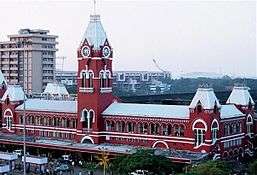
- Chennai Central railway station
- Moore Market Complex
- Chennai Park railway station
- Victoria Public Hall
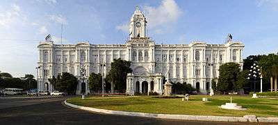
- Ripon Building
- Government Fine Arts College
- Chennai Traffic Police Headquarters
- St. Andrew's Church
- Wesley Church
- Nehru Park
- Sangam Theatre Complex
- Kumaran Hospital
- Kilpauk Medical College and Hospital
- Ega Theatre
- Pachaiyappa's College
- St. Georges Higher Secondary School
- Ampa Skywalk mall
- Government Hospital of Indian Medicine
- Anna Arch
- Dwaraka Doss Goverdhan Doss Vaishnav College
- Koyambedu grade separator
- Rohini Theatre Complex
- Maduravoyal grade separator
- Sindhi College
- ACS Medical College and Hospital
- Saveetha Dental College
Widening
In May 2013, a 300-m stretch of the road at Shenoy Nagar near Aminjikarai which acted as a bottleneck was widened, following a Madras High Court ruling. Officials of the state highways department cleared the encroachments that had reduced the width of the road.[8]
Future projects
In the early 2000s, Chennai Metropolitan Development Authority (CMDA) conceived an idea of a 6.5-km stretch connecting the two arterial stretches of Poonamallee High Road and Anna Salai in the city. The idea is to create a traffic corridor connecting Anna Salai and Poonamallee High Road through the congested neighbourhoods of Chetpet, Nungambakkam and T. Nagar. In 2014, the Corporation modified the original alignment to create two corridors, namely, a 3.5-km stretch from Anna Salai to Mahalingapuram and a 3-km flyover connecting Thirumalai Pillai Road and Poonamallee High Road (covering five traffic bottlenecks in Chetpet junction, Sterling Road junction, Tank Bund Road junctions and Valluvar Kottam High Road junction).[9]
In 2014, the highways department fixed the alignment of a 5.18-km-long, 4-laned elevated corridor that will take off at Raja Muthiah Salai, near Ripon Buildings, and descend near Pulla Reddy Avenue in Shenoy Nagar. The project has been estimated to cost ₹4,500 million.[7]
References
| Wikimedia Commons has media related to Poonamallee High Road, Chennai. |
- ↑ Ramkumar, Pratiksha (9 February 2013). "Hospitals go in for specialty makeover". The Times of India. Chennai: The Times Group. Retrieved 11 February 2013.
- ↑ "Traffic happier as PH Road widened". The Hindu. Chennai. 5 March 2013. Retrieved 6 March 2013.
- 1 2 Mariappan, Julie (6 March 2013). "90-minute nightmare to cross nine kilometres". The Times of India. Chennai. Retrieved 6 Mar 2013.
- ↑ "Re-laying of Poonamallee High Road begins". The Hindu. Chennai. 3 February 2014. Retrieved 9 Feb 2014.
- ↑ Hemalatha, Karthikeyan (25 June 2013). "Poonamallee road to get wider bridge over Cooum". The Times of India. Chennai: The Times Group. Retrieved 30 Jun 2013.
- ↑ Josephine M., Serena (10 March 2014). "P.H. Road remains doctors' dream destination". The Hindu. Chennai: The Hindu. Retrieved 27 Mar 2014.
- 1 2 Ramakrishna, Deepa H. (28 October 2014). "Alignment fixed for elevated corridor in Chennai". The Hindu. Chennai: The Hindu. Retrieved 1 November 2014.
- ↑ Selvaraj, A. (1 May 2013). "Highways pulls down shops, widens road near Aminjikarai". The Times of India. Chennai. Retrieved 5 May 2013.
- ↑ Xavier Lopez, Aloysius (7 February 2014). "Anna Salai-P.H. Road corridor idea takes shape". The Hindu. Chennai. Retrieved 9 Feb 2014.
| Companies and organisations |
| ||||||||||||||
|---|---|---|---|---|---|---|---|---|---|---|---|---|---|---|---|
| Airports |
| ||||||||||||||
| Rail Transport |
| ||||||||||||||
| Roads |
| ||||||||||||||
| Water/Sea Transport | |||||||||||||||
| |||||||||||||||