Entre-Ijuís
| Entre-Ijuís | |
|---|---|
| Municipality | |
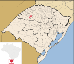 Location in Rio Grande do Sul state | |
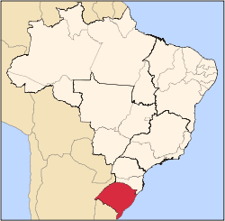
 Entre-Ijuís Location in Brazil | |
| Coordinates: 28°21′36″S 54°16′4″W / 28.36000°S 54.26778°WCoordinates: 28°21′36″S 54°16′4″W / 28.36000°S 54.26778°W | |
| Country |
|
| State | Rio Grande do Sul |
| Micro-region | Santo Ângelo |
| Area | |
| • Total | 552.60 km2 (213.36 sq mi) |
| Population (2015) | |
| • Total | 9,037 |
| • Density | 16/km2 (42/sq mi) |
| Time zone | BRT (UTC-3) |
| • Summer (DST) | BRST (UTC-2) |
Entre-Ijuís is a municipality of the western part of the state of Rio Grande do Sul, Brazil. The population is 9,037 (2015 est.) in an area of 552.60 km².[1] It takes its name from the Ijuí River, on which it is situated. It is located 435 km west of the state capital of Porto Alegre, northeast of Alegrete.
Bounding municipalities
References
External links
- http://www.citybrazil.com.br/rs/entre-ijuis/ (Portuguese)
This article is issued from Wikipedia - version of the 5/15/2016. The text is available under the Creative Commons Attribution/Share Alike but additional terms may apply for the media files.