São Francisco de Assis, Rio Grande do Sul
| Terra Boa | |
|---|---|
| Municipality | |
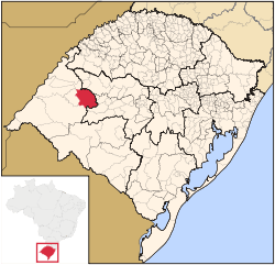 Location within Rio Grande do Sul | |
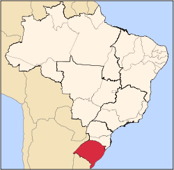
 Terra Boa Location in Brazil | |
| Coordinates: 29°33′1″S 55°7′52″W / 29.55028°S 55.13111°WCoordinates: 29°33′1″S 55°7′52″W / 29.55028°S 55.13111°W | |
| Country |
|
| State | Rio Grande do Sul |
| Mesoregion |
Southwestern Rio Grande do Sul (Sudoeste Rio-Grandense) |
| Microregion | Campanha Ocidental |
| Founded | January 4, 1884 |
| Area | |
| • Total | 2,503.9 km2 (966.8 sq mi) |
| Elevation | 151 m (495 ft) |
| Population (2003) | |
| • Total | 20,645 |
| • Density | 8.2/km2 (21/sq mi) |
| Demonym(s) | Assissense |
| Time zone | BRT (UTC-3) |
| • Summer (DST) | BRST (UTC-2) |
| Postal code | 97610-xxx |
| IBGE code | 4318101 |
| Website | saofranciscoassis.rs.gov.br |
São Francisco de Assis is a Brazilian municipality in the western part of the state of Rio Grande do Sul. It has a population of 20,645 (2005). Its elevation is 151 m. It has an area of 2,530.9 km². It is located 434 km west of the state capital of Porto Alegre. The nickname of the city is Sao Chico.
The city is situated by the Jaguari, near the city of Santa Maria. They plant soy and produce milk. The city had been showing significant growth, compared to the last decade.
References
External links
- http://www.citybrazil.com.br/rs/saofranciscoassis/ (Portuguese)
This article is issued from Wikipedia - version of the 11/17/2016. The text is available under the Creative Commons Attribution/Share Alike but additional terms may apply for the media files.