Erechim
| Erechim | |||
|---|---|---|---|
| Municipality | |||
| The Municipality of Erechim | |||
|
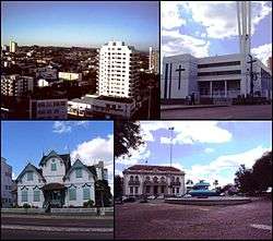
Top left:View of downtown Aratiba area, Top right:Erechin Cathedral, Bottom left:Castelinho native house in Alemanda street, Bottom right:A fountain in Bandeira Square, near Tiradentles Avenue | |||
| |||
| Nickname(s): Flower city | |||
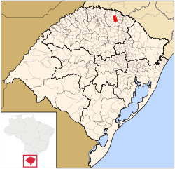 Location of Erechim | |||
 Erechim Location in Brazil | |||
| Coordinates: 27°38′02″S 52°16′26″W / 27.63389°S 52.27389°WCoordinates: 27°38′02″S 52°16′26″W / 27.63389°S 52.27389°W | |||
| Country |
| ||
| Region | South | ||
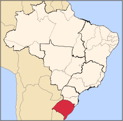
| State | Rio Grande do Sul | ||
| Founded | Abril 30, 1918 | ||
| Government | |||
| • Mayor | Paulo Pólis (PT) | ||
| Area | |||
| • Total | 430,764 km2 (166,319 sq mi) | ||
| Elevation | 783 m (2,569 ft) | ||
| Population (2012) | |||
| • Total | 97,916 | ||
| • Density | 227/km2 (590/sq mi) | ||
| Time zone | UTC-3 (UTC-3) | ||
| • Summer (DST) | UTC-2 (UTC-2) | ||
| Postal Code | 99700-000 | ||
| Area code(s) | +55 54 | ||
| Website | Erechim, Rio Grande do Sul | ||


Erechim is a Brazilian municipality located in the southern state of Rio Grande do Sul. A regional center in the northern portion of the state, it is the second most populous city in the region with 97,916 inhabitants, second only to the city of Passo Fundo. The municipality ranks 17th in total gross domestic product in the state of Rio Grande do Sul.
Erechim was one of the first planned modern cities in Brazil. City planners were inspired by urban concepts used in the design of Washington, D.C. (1791) and Paris (1850). These were characterized by very wide streets and bold outlines, with diagonal streets converging at important points. Key elements of its design include a perpendicular grid of streets cut by diagonal avenues, blocks of regular dimensions and a promenade around its perimeter.
The municipality is located north of Rio Grande do Sul, in the Upper Uruguay, on the ridge of the Serra Geral. The origin of the name of Erechim refers to the ancient indigenous inhabitants of the region, and comes from "Erechim Caingangue", which means "small field"; it probably was given this name as the city was surrounded by forests at the time.
History
.jpg)
The city was initially called the Great Barn and then successively named Boa Vista, Boa Vista Erechim, Jose Bonifacio Erechim and finally just Erechim. Like many other villages in Brazil, it was built beside the railroad, in this case, the railroad that linked Rio Grande do Sul to São Paulo.
The town was settled mostly by Polish, Italian and German immigrants, 36 pioneers from Europe and others from the old lands (Caxias do Sul). They came by railroad in 1908, building their homes beside the track, and the place soon became a district of Passo Fundo.
The town's early economy depended on agriculture, livestock production, trade and services. It thrived and the city of Erechim was created on April 30, 1918, through Decree No. 2343 of April 30, signed by Antonio Borges, then governor of Rio Grande do Sul.
Once known as the "Capital of Wheat" due to the high volumes of grain produced, today Erechim is considered the "Capital of Friendship".
Origins of the city's urban design
The following testimony was written in 1970 by José Maria de Amorim, the first clerk of Erechim, who lived there from 1924 until the date of his death on December 12, 1978. He recounts the design aspects of the city, its origin and its setbacks, which are not yet recorded in the official history of the county.
As mentioned previously, Erechim was created on April 30, 1918, by decree of the then State President Dr. Antonio Augusto Borges de Medeiros. Once formalized all necessary steps for the official act of creation, the Secretary of Public Works C. Gonçalves Torres ordered the geodesic division of the city that would serve as headquarters to the novel by county engineers and surveyors of the Land Committee, which worked in the old town Erechim (today Getulio Vargas). And they took as its starting point the train station, without having done so, it seems, the reconnaissance of the terrain.The design repeated the plant in the city of Belo Horizonte, capital of Minas Gerais, also was inspired by urban concepts used in the tracings of Washington (1791) and Paris (1850) [9]. With plans in place, development of Erechim proceeded at a rapid pace, especially Avenida Jose Bonifacio, now called Maurício Cardoso.
Before long, news of the booming region's progress interest Torres Gonçalves, who came to visit the village, hoping to find it lying on flat terrain and easy to implement, with flat streets, with its triangular terminals perfectly leveled. But when he arrived and traveled aboard a 1929 Ford automobile, which growled furiously over steep hills of the streets, it was as he expected. Erechim indeed was built on hilly ground!
With the passage of time, the city was eventually leveled to the existing gully Avenue Maurício Cardoso, channeled the existing establishments in the first blocks of streets and Nelson Italy Ehlers, and many other depressions were more or less leveled with wood and earth.
On a visit to me, the notary Jose Maria Henriques de Amorim confessed that Erechim was his "greatest sin," because I never thought that the city had been planted on holes. And every time I returned there and visited Amorim said the notary public upon arrival "My friends, come see my sin." That was how Erechim called "my sin." And he was right. Later there have been big studies to see if it was possible to improve the geographical situation of the city, but all to no avail. The last work performed by the former Land Commission was a survey that lasted many months, led by Schneider dium, the Brother Malinowski, Losina brothers, Anthony and Henry Bergmann Schwerin, who did a survey every two square feet, as the situation. Even before the end of this service, one time mayor of the City Council ordered the surveyor's leveling the pavement and the strings were extended, with all the defects of the surface.
And so it was following the city, where many governments have tried in vain to level the city. Later drew up the Master Plan that had on the urban construction. With him, it was granted leveling many buildings before making the leveling of streets, which resulted in houses with many floors underground, after the street as it should be capped, to mitigate the steep subidas.Como is not difficult to guess there was great excitement in town about this master plan, which eventually shelved.
Today Erechim, with its ups and downs, is still thriving and flourishing. It has the air of a big city, with its cobbled streets and low buildings, and is increasingly known as the Capital of Friendship.
Notable people
Victoria's Secret supermodel Alessandra Ambrosio (b. 1981) was born in Erechim.
Also well known are Erechim born soccer players including former goalkeeper Gilmar Rinaldi, who played at Internacional, São Paulo and Flamengo. Striker Rafael Sóbis, currently playing at Tigres UANL and the former midfielder and current coach, Paulo Cesar Carpeggiani.
Transportation
Erechim is served by Erechim Airport with scheduled flights to various cities.
The city can be reached by road via state highways RS-135, RS-331, RS-419, RS-420, RST-480, and federal highways BR-153 and BR-480. These roads link the various municipalities in the region and are all paved. Erechim lies 360 km from the state capital, Porto Alegre.
References
| Wikimedia Commons has media related to Erechim. |
| Wikivoyage has a travel guide for Erechim. |